
 How to resolve AdBlock issue?
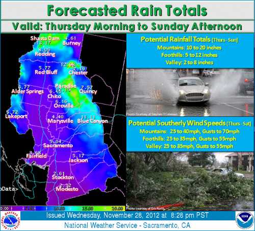
LAKE COUNTY, Calif. – The first of three weather systems rolled through Lake County on Wednesday, bringing heavy rains and gusty winds, and removing most of the remaining autumn leaves from trees.
The rain isn’t over yet, with forecasters reporting that two more intense storms are taking aim for Lake County.
The first storm in the series moved out of Lake County early Wednesday afternoon, leaving behind more than an inch of rain in most areas, according to Western Weather Group.
The National Weather Service in Sacramento is forecasting rain accumulations of 6 to 12 inches by Sunday in areas of Lake County. A flood watch in urban areas and small streams remains in effect throughout the weekend, as summer-dry creeks have begun flowing for the first time of the season on Wednesday.
Steady rains will continue to increase throughout the day Thursday as the second of the third storm systems moves through, becoming heavier into the overnight, with accumulations of up to 4 inches or more predicted.
A wind advisory also is in effect, and winds will continue to increase throughout the day, raising chances for localized power outages due to downed power lines from falling trees as the ground becomes saturated.
Temperatures are forecast to remain mild – in the 50s – throughout the day and into the evening, as the second, warmer storm drops copious amounts of rain in Lake County and much of Northern California.
Forecast models currently have the slightly cooler third storm moving in on Friday, bringing the chance of thunderstorms to Lake County, but with less rain than the previous two storms, and lingering throughout Saturday.
Rain is likely to continue on Sunday according to the National Weather Service in Sacramento, with slightly cooler temperatures, but will still remain in the 50s during the day with overnight temperatures in the 40s.
A wind advisory currently is in effect until Saturday according to the National Weather Service in Sacramento. Some areas may see gusts up to 70 miles per hour at higher elevations. A flood watch remains in effect through Sunday afternoon.
Residents are urged to use caution when driving through areas impacted by the summer wildfires, particularly Highway 20, as debris flows and mudslides can overwhelm creeks and roadside ditches, causing water to cover the road and make driving hazardous.
Remember to use caution at all times when driving in inclement weather including reducing driving speed, increasing the distance between the car in front of you, and to not drive through standing water that covers road.
Email Terre Logsdon at


