
 How to resolve AdBlock issue?
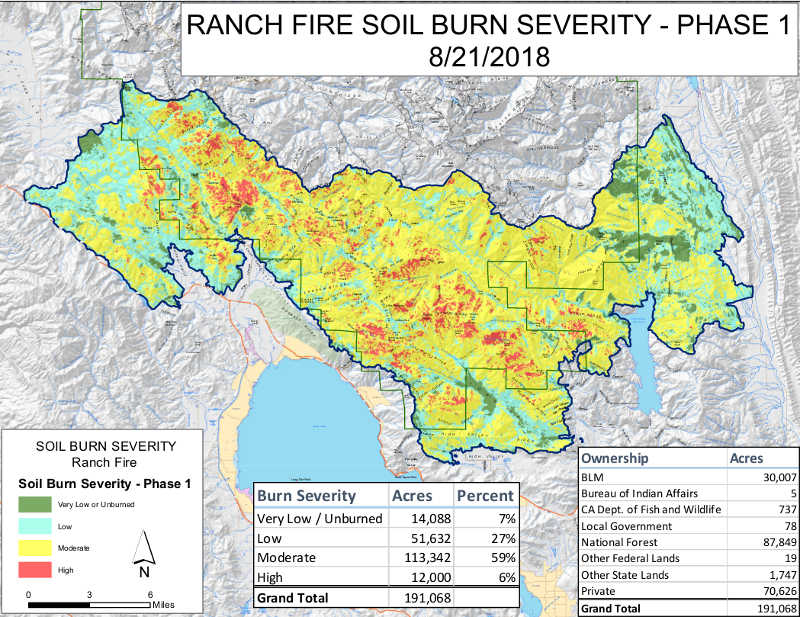
UPPER LAKE, Calif. – Burned Area Emergency Response, or BAER, specialists from the U.S. Forest Service and the Department of Interior recently completed their data gathering and field work of the Ranch fire burn area, part of the Mendocino Complex.
Their focus was to verify and finalize the soil burn severity map. Soil burn severity is classified into levels between unburned and high.
Due to the size of the fire, its activity, and the team’s inability to visit the northern portion of the fire, the BAER team assessed the southern portion of the fire, an area 191,068 acres in size.
The northern portion will be mapped at a future date once activity drops and the specialists are allowed into the burned area.
The analysis indicated that approximately seven percent of the area in the fire perimeter is considered unburned or very low (14,090 acres), 27 percent low (51,633 acres), 59 percent moderate (113,344 acres), and six percent high (12,000 acres) soil burn severity.
BAER post-fire assessment teams use the soil burn severity data to identify if there are areas of concern where increased soil erosion, accelerated surface water run-off, and debris flows have the potential to impact human life and safety, property, and critical natural and cultural resources from rain events.
BAER teams typically consist of scientists and specialists that consider emergency stabilization options for those critical resources.
The soil burn severity map is not an erosion risk map, but generally shows increases in the rates of erosion and runoff that are expected from steep hillslopes with high and moderate soil burn severity.
Areas located downstream from moderate and high soil burn severity, even within unburned areas, may experience increased rates of erosion, debris flows and surface runoff due to cumulative effects.
Information about the BAER team’s work can be found on Inciweb: https://inciweb.nwcg.gov/incident/6156.


