How to resolve AdBlock issue?
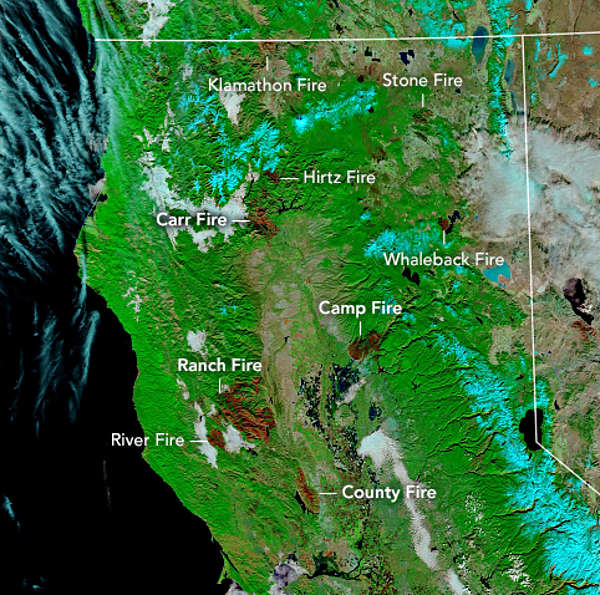
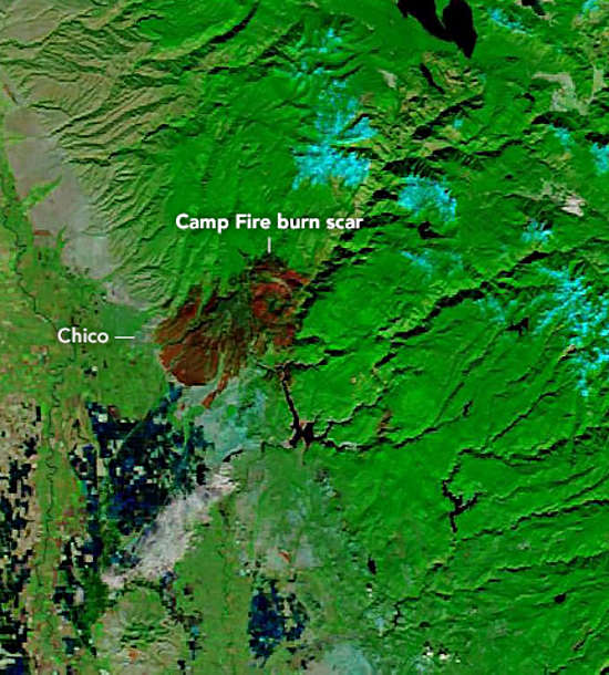
NORTHERN CALIFORNIA – New images released this week by NASA’s Earth Observatory show the impact of this year’s wildland fires on the Northern California landscape.
The 2018 fire season in California has been record-breaking.
The Mendocino Complex – the majority of which burned in Lake County – was California’s largest fire by burned area on record, destroying nearly half a million acres. In began July 27 in Mendocino County and continued until Sept. 18, ultimately burning not just into Lake but also Colusa and Glenn counties.
The Camp fire in November was the deadliest and most destructive in state history, completely wiping out the town of Paradise and killing dozens of people.
“Every year, we keep hearing fires labeled as ‘the biggest,’ ‘worst’ and ‘deadliest’,” said Amber Soja, a wildfire scientist at NASA’s Langley Research Center. “We keep hearing that this is the ‘new normal.’ Hopefully it’s not true for long, but right now it is.”
In addition to the Mendocino Complex – which included the Ranch and River fires – and the Camp fire, the top image shows the burn scars for the following fires:
– Carr fire: July 23 to Aug. 30 in Shasta and Trinity counties, burned more than 1,600 structures and 229,651 acres; eight fatalities – three firefighters, five civilians.
– County fire: July 17 to 30 in Napa and Yolo counties, destroyed 20 structures and burned 90,288 acres.
– Hirz fire: Aug. 9 to Sept. 12 in Shasta County, burned 46,150 acres.
– Klamathon fire: July 5 to 21 in Siskiyou County, burned 38,008 acres and destroyed 82 structures; one fatality.
– Stone fire: Aug. 15 to Aug. 29, Modoc County, burned 39,387 acres.
– Whaleback fire: July 27 to Aug. 7, burned 18,703 acres.
California’s fire activity in 2018 is part of a longer trend of larger and more frequent fires in the western United States.
Of the total area burned in the West since 1950, 61 percent of it has occurred in the past two decades, according to Keith Weber, GIS director at Idaho State University and principal investigator of the NASA project RECOVER.
“The 2018 fire year is going to fit right in to what's been going on the last decade or two. In fact, it might be a taller spike in the overall trend,” Weber said.
High temperatures, low relative humidity, high wind speed, and scarce precipitation have increased dryness and made live and dead vegetation in western forests easier to burn.
“Those fire conditions all fall under weather and climate,” said Soja. “The weather will change as Earth warms, and we’re seeing that happen.”
Soja also noted that California had a really wet winter in 2017, which helped build up grass and brush in rural and forested areas.
The vegetation was an abundant fuel source as California headed into the 2018 dry season, which was exceptionally dry and lasted into late October.
As fires are becoming more numerous and frequent, NASA’s Disasters Program has been working with disaster managers to respond to the blazes.
For California’s Camp and Woolsey fires, NASA scientists and satellite analysts have been producing maps and damage assessments of the burned areas, including identifying areas that will be more susceptible to landslides in the upcoming winter.
Kasha Patel is a science writer at NASA.