17 July 2025
Lake County governments adopt state’s new fire hazard map; ‘very high’ severity zones expanded by 14,000 acres
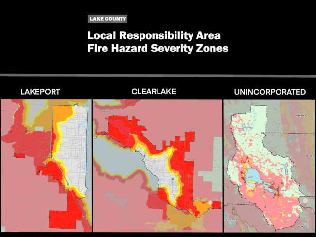
LAKE COUNTY, Calif. — By the end of June, the Board of Supervisors and two city councils voted to approve an ordinance adopting the state’s new fire hazard severity zone map, which has significantly expanded the county’s highest fire hazard acreage designation.
The new map will take effect by the end of July — 30 days after each jurisdiction held its second public hearing approving the ordinance.
Under current state policies and local considerations, properties within the higher severity zones will be subjected to mandatory disclosure during real estate transactions and stricter standards on building code, road width, water supply and defensible space, according to Clearlake City Manager Alan Flora in the city’s first public hearing in May.
The state’s “Zone 0” policy — prohibiting combustible materials within five feet of structures — will also apply to the most hazardous zones.
The biggest concern across the board remains the accessibility and affordability of fire insurance for Lake County homeowners, many of whom are already experiencing difficulties, according to county and city officials.
Despite reluctance and concerns, elected officials voted to adopt the map. All supervisors except Supervisor Helen Owen voted in favor of adoption. In Clearlake and Lakeport, all council members voted yes, albeit reluctantly.
The most common criticism of the map has been the lack of genuine and sufficient local input in creating and adjusting the map.
After all, local map adoption through an ordinance is mandated by the state law.
“I'm a little confused on how it can be required by the state, and yet we still have to accept it, in all honesty,” Owen said during the Board of Supervisors’ second hearing of the tension between a mandate and a majority vote.
In an earlier interview with Lake County News, Supervisor Bruno Sabatier said local jurisdictions can technically vote against the map, but such noncompliance could create problems and obstacles for future development projects. “I see no other step to take than to approve the maps as provided by the state,” he said.
This new map, released by Cal Fire in February, designated “local responsibility areas,” or LRA — areas managed by city and county governments — into “very high,” “high” and “moderate” fire hazard severity zones.
It marks the first update to the LRA designations since 2011 and adds 14,000 acres in Lake County to the “very high” zone — an 878% expansion in acreage classified as the most hazardous.
According to Cal Fire, the maps assess fire hazard based on “the physical conditions that create a likelihood and expected fire behavior over a 30- to 50-year period.”
Cal Fire says the long-term projection method means local fire mitigation efforts — which are considered short-term — would not reduce the zone rating in the map.
As the state law requires, local jurisdictions can adopt the map as is or make it more stringent; they cannot lower the rating.
Local government and fire officials have spoken against the 50-year projection since the release of the map. At Lakeport’s first public hearing on the map in June, Councilmember Kenny Parlet again criticized the rationale of basing the map rigidly on such a long-term projection.
“I would say that we oppose a 50-year map of any kind for anything most of the time, because things change, and it's just — it's ridiculous, because we don't know what kind of new technology, or what kind of different mitigations we can do as a city,” Parlet said. “And I think that is just ludicrous that someone in office now could tell our great, great-grandchildren what their fire severity is. I just think that is absolutely ridiculous.”
‘Split-zoned parcels’ dilemma
The fire hazard severity zones in the map, however, do not align with the parcel boundaries that local jurisdictions use for planning.
As a result, despite uniform adoption, the three local governments have chosen different approaches to parcels that stride across more than one severity-zone designations, namely “split-zone parcels.”
Clearlake adopted a modified version of the fire map to only reflect the higher designation for such parcels for better clarity. The Board of Supervisors and Lakeport City Council, however, adopted the map as is without adjusting any zone rating.
For Lakeport, City Manager Kevin Ingram said during the first public hearing that the city has some “long and skinny” parcels that stretch across three fire severity zones. Some parcels at the north end of the city may have 40% “moderate” and a small sliver of “very high.” Staff, therefore, did not recommend treating this entire parcel as “very high.”
During the Board of Supervisors’ first hearing, there was some discussion on whether the rating for a split-zoned parcel could be based on the lowest rated zone. It was brought up that some other jurisdictions did so, but Supervisor Bruno Sabatier doubted the legitimacy of such action, citing the state law prohibiting lowering the zone ratings.
Paul Duncan of Cal Fire said it makes little difference in Lake County, where most structures must already comply with the most stringent building code — 7A — since the majority of the county falls within the Wildland-Urban Interface area.
Duncan said the only real effect is the “exposure requirement” for selling properties within the “high” and “very high” zones.
The “bigger elephant in the room,” Duncan said, is lowering fire hazard and insurance costs for property owners.
Supervisor Owen made a point here and said such hazard disclosure was exactly what the insurance companies say they are not looking at. “You know they’re going to,” she added.
“The state likes to stress that the map is not for insurance,” said County Chief Climate Resiliency Officer/Tribal Liaison Terre Logsdon at the beginning board meeting. “Insurance Commissioner Lara issued a California consumer alert that says it's not — we all know that they do look at it.”
Supervisor Jessica Pyska urged the board to approve the state’s map as is and work internally for local details.
“It’s not our map; they are not ours,” said Pyska. “We can make changes internally as we see fit, but we don't have to make those decisions today. We can just adopt these maps and move down the road and work on what works best for Lake County on our timeline.”
During public comment, Lakeport Fire Protection District Chief Patrick Reitz also voiced his support for adopting the map as is instead of upzoning split-zoned parcels to the highest designation, to offer an option for property owners to build their house in the less severe zones within their parcel.
“I'd appreciate it if you leave my lot alone — if I have a split lot,” said Reitz.
For an “unfunded mandate” as Reitz called it, “Don't waste any time. Don't waste any money. We've got a lot of big issues to deal with. This isn't one,” he said.
Local governments agreed to send letters of disapproval
Alongside the adoption, all three governments during their public hearings agreed to send letters to express disapproval of the map and the process.
Clearlake’s letter pointed to a lack of genuine local decision making in the “blanket adoption” that “fails to consider the unique characteristics and existing mitigation efforts of individual communities.”
“Our community suffers from a high level of poverty and many will not be able to meet the standards of the ordinance on their own,” the letter stated. “We expect significant numbers of insurance non-renewals that are likely to devastate a large percentage of our population.”
The letter continued to ask for genuine local input on the matter: “We urge you to respect more local input into similar mandates and instead allow for a more collaborative process that respects local decision-making.”
The Clearlake City Council members approved the letter, addressed to Gov. Gavin Newsom, in their June 5 meeting.
The Board of Supervisors and the Lakeport City Council have not sent out the letter. Both told Lake County News that they were to discuss the matter in July.
Email staff reporter Lingzi Chen at lchen@lakeconews.com.
Author Elizabeth Larson
LAKE COUNTY, Calif. — By the end of June, the Board of Supervisors and two city councils voted to approve an ordinance adopting the state’s new fire hazard severity zone map, which has significantly expanded the county’s highest fire hazard acreage designation.
The new map will take effect by the end of July — 30 days after each jurisdiction held its second public hearing approving the ordinance.
Under current state policies and local considerations, properties within the higher severity zones will be subjected to mandatory disclosure during real estate transactions and stricter standards on building code, road width, water supply and defensible space, according to Clearlake City Manager Alan Flora in the city’s first public hearing in May.
The state’s “Zone 0” policy — prohibiting combustible materials within five feet of structures — will also apply to the most hazardous zones.
The biggest concern across the board remains the accessibility and affordability of fire insurance for Lake County homeowners, many of whom are already experiencing difficulties, according to county and city officials.
Despite reluctance and concerns, elected officials voted to adopt the map. All supervisors except Supervisor Helen Owen voted in favor of adoption. In Clearlake and Lakeport, all council members voted yes, albeit reluctantly.
The most common criticism of the map has been the lack of genuine and sufficient local input in creating and adjusting the map.
After all, local map adoption through an ordinance is mandated by the state law.
“I'm a little confused on how it can be required by the state, and yet we still have to accept it, in all honesty,” Owen said during the Board of Supervisors’ second hearing of the tension between a mandate and a majority vote.
In an earlier interview with Lake County News, Supervisor Bruno Sabatier said local jurisdictions can technically vote against the map, but such noncompliance could create problems and obstacles for future development projects. “I see no other step to take than to approve the maps as provided by the state,” he said.
This new map, released by Cal Fire in February, designated “local responsibility areas,” or LRA — areas managed by city and county governments — into “very high,” “high” and “moderate” fire hazard severity zones.
It marks the first update to the LRA designations since 2011 and adds 14,000 acres in Lake County to the “very high” zone — an 878% expansion in acreage classified as the most hazardous.
According to Cal Fire, the maps assess fire hazard based on “the physical conditions that create a likelihood and expected fire behavior over a 30- to 50-year period.”
Cal Fire says the long-term projection method means local fire mitigation efforts — which are considered short-term — would not reduce the zone rating in the map.
As the state law requires, local jurisdictions can adopt the map as is or make it more stringent; they cannot lower the rating.
Local government and fire officials have spoken against the 50-year projection since the release of the map. At Lakeport’s first public hearing on the map in June, Councilmember Kenny Parlet again criticized the rationale of basing the map rigidly on such a long-term projection.
“I would say that we oppose a 50-year map of any kind for anything most of the time, because things change, and it's just — it's ridiculous, because we don't know what kind of new technology, or what kind of different mitigations we can do as a city,” Parlet said. “And I think that is just ludicrous that someone in office now could tell our great, great-grandchildren what their fire severity is. I just think that is absolutely ridiculous.”
‘Split-zoned parcels’ dilemma
The fire hazard severity zones in the map, however, do not align with the parcel boundaries that local jurisdictions use for planning.
As a result, despite uniform adoption, the three local governments have chosen different approaches to parcels that stride across more than one severity-zone designations, namely “split-zone parcels.”
Clearlake adopted a modified version of the fire map to only reflect the higher designation for such parcels for better clarity. The Board of Supervisors and Lakeport City Council, however, adopted the map as is without adjusting any zone rating.
For Lakeport, City Manager Kevin Ingram said during the first public hearing that the city has some “long and skinny” parcels that stretch across three fire severity zones. Some parcels at the north end of the city may have 40% “moderate” and a small sliver of “very high.” Staff, therefore, did not recommend treating this entire parcel as “very high.”
During the Board of Supervisors’ first hearing, there was some discussion on whether the rating for a split-zoned parcel could be based on the lowest rated zone. It was brought up that some other jurisdictions did so, but Supervisor Bruno Sabatier doubted the legitimacy of such action, citing the state law prohibiting lowering the zone ratings.
Paul Duncan of Cal Fire said it makes little difference in Lake County, where most structures must already comply with the most stringent building code — 7A — since the majority of the county falls within the Wildland-Urban Interface area.
Duncan said the only real effect is the “exposure requirement” for selling properties within the “high” and “very high” zones.
The “bigger elephant in the room,” Duncan said, is lowering fire hazard and insurance costs for property owners.
Supervisor Owen made a point here and said such hazard disclosure was exactly what the insurance companies say they are not looking at. “You know they’re going to,” she added.
“The state likes to stress that the map is not for insurance,” said County Chief Climate Resiliency Officer/Tribal Liaison Terre Logsdon at the beginning board meeting. “Insurance Commissioner Lara issued a California consumer alert that says it's not — we all know that they do look at it.”
Supervisor Jessica Pyska urged the board to approve the state’s map as is and work internally for local details.
“It’s not our map; they are not ours,” said Pyska. “We can make changes internally as we see fit, but we don't have to make those decisions today. We can just adopt these maps and move down the road and work on what works best for Lake County on our timeline.”
During public comment, Lakeport Fire Protection District Chief Patrick Reitz also voiced his support for adopting the map as is instead of upzoning split-zoned parcels to the highest designation, to offer an option for property owners to build their house in the less severe zones within their parcel.
“I'd appreciate it if you leave my lot alone — if I have a split lot,” said Reitz.
For an “unfunded mandate” as Reitz called it, “Don't waste any time. Don't waste any money. We've got a lot of big issues to deal with. This isn't one,” he said.
Local governments agreed to send letters of disapproval
Alongside the adoption, all three governments during their public hearings agreed to send letters to express disapproval of the map and the process.
Clearlake’s letter pointed to a lack of genuine local decision making in the “blanket adoption” that “fails to consider the unique characteristics and existing mitigation efforts of individual communities.”
“Our community suffers from a high level of poverty and many will not be able to meet the standards of the ordinance on their own,” the letter stated. “We expect significant numbers of insurance non-renewals that are likely to devastate a large percentage of our population.”
The letter continued to ask for genuine local input on the matter: “We urge you to respect more local input into similar mandates and instead allow for a more collaborative process that respects local decision-making.”
The Clearlake City Council members approved the letter, addressed to Gov. Gavin Newsom, in their June 5 meeting.
The Board of Supervisors and the Lakeport City Council have not sent out the letter. Both told Lake County News that they were to discuss the matter in July.
Email staff reporter Lingzi Chen at This email address is being protected from spambots. You need JavaScript enabled to view it..

 How to resolve AdBlock issue?


