LAKE COUNTY, Calif. – Autumn is deer mating season – which means deer are on the move and less cautious about darting out into the road.
In the past two weeks, Caltrans crews in Ukiah and Lake County have seen an increase in deer collisions.
"This happens every fall, but it catches drivers off guard, especially at dusk and right before dawn,” said Caltrans Maintenance Manager Marty Sills.
It is also mating season for elk, which are less numerous than deer, but just as hazardous to motorists here in Northern California.
Drivers should be extra vigilant this time of year and follow these tips for driving in deer country:
– Be particularly attentive between sunset and midnight, the hours shortly before and after sunrise, and in foggy conditions. Most deer-vehicle collisions occur during these times.
– Drive carefully in areas known to have high deer populations. Places where roads divide agricultural fields or streams from forestland are particularly dangerous.
– If you see a deer, slow down. Others are probably nearby.
– Use high-beam headlights when there is no oncoming traffic. The high beams can reflect off animal eyes and warn you of their presence.
– If a deer is in your lane, brake firmly but stay in the lane. The most serious crashes occur when drivers swerve.
– Don't rely on deer whistles, deer fences or reflectors to deter deer.
– If your car strikes a deer, don't touch the animal. If the deer is blocking the highway, call 911.
For more safety information and the latest updates like Caltrans District 1 on Facebook.
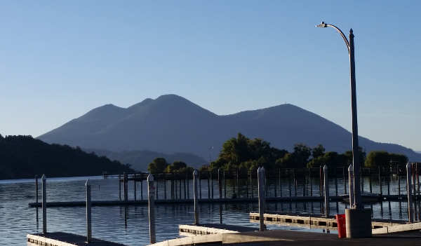
Mount Konocti is the key feature of the Clear Lake Volcanic Field in Lake County, Calif. Photo by John Jensen/Lake County News. LAKE COUNTY, Calif. – An update to the U.S. Volcanic Threat Assessment puts the Clear Lake Volcanic Field among a group of volcanoes in the “high” risk category, with other volcanoes around California and the Pacific Rim rating even higher for danger.
The new U.S. Geological Survey report, which updates the first assessment released in 2005, ranks the 161 young, active volcanoes within the United State’s borders.
Sitting on the western shore of Clear Lake, the Clear Lake Volcanic Field’s most notable feature is Mount Konocti. It was ranked at No. 33, in the “high” threat category.
Elsewhere in California, the assessment lists Mt. Shasta and Lassen Volcanic Center in the “very high” ranking, placing them No. 5 and No. 11, respectively. The Long Valley Caldera in the Inyo National Forest near Yosemite National Park is in the very high threat category, at No. 18. The Mono-Inyo Craters, also near Yosemite, was listed in the “high” category at No. 24.
This 2018 update considers field and laboratory research that adds or removes volcanoes from the list of potentially active volcanoes, and updates the hazard and exposure factors used to produce a relative threat ranking of volcanoes.
Officials said the new document also adds or raises the threat level for 12 volcanoes and reduces or removes threat level status from 20 volcanoes.
The USGS said that, since 1980, there have been 120 eruptions and 52 episodes of notable volcanic unrest at 44 U.S. volcanoes.
John Ewert, a USGS volcanologist and lead author of the new assessment report based at the Cascades Volcanic Observatory in Vancouver, said the threat rankings are not an indication of which US volcano will erupt next but rather an indicator of the severity of impacts.
“The U.S. has quite a few geologically active volcanoes,” Ewert said.
Ewert said the 161 volcanoes in the study – eight less than the 2005 report, a net change due to the result of additions, naming changes and new research – make up about 10 percent of the earth’s active volcanoes, and have a large footprint over the United States extending from the Arctic to the tropics. Fourteen states and territories have volcanoes considered by this assessment.
“The US has nearly every type of volcano,” which are found in wildly different settings, said Ewert. What is known about their history varies greatly.
The survey systematically assesses U.S. volcanoes considered to be active or potentially active, and ranks the volcanoes based on 24 hazard and exposure factors. “To be included in the assessment, a volcano had to meet certain criteria,” said Ewert.
One of the key criteria is that a volcano has been active in geologically “recent time,” which Ewert explained is the Holocene, the current geological epoch which began nearly 12,000 years ago.
Once they assess the 24 factors for each volcano, they then group them into five categories. When ranking volcanoes, Ewert said that they combine the exposure and hazard scores, which highlight volcanoes that might otherwise have gotten lower.
He said 18 volcanoes in the United States are ranked as very high threat, and that group remains unchanged since the 2005 assessment.
There are 39 volcanoes in the high threat category, with Salton Buttes in California and Fourpeaked Mountain in Alaska added to the list; 49 volcanoes ranked as moderate, with new additions of Soda Lakes in Nevada and East Diamante in the commonwealth of the Northern Mariana Islands; 34 ranked as low threat; and 21 ranked as “very low threat,” the category that underwent the greatest changes due to new information, Ewert said.
This latest report also includes ash cloud risks, which was in the 2005 report. Ewert said the 2010 eruption in Iceland of the volcano Eyjafjallajökull, which went on for a six-month period and caused a six-day disruption in European air travel reported to be the most significant since World War II due to its enormous smoke output, is a good example of why it’s important to prioritize ash risk.
Ewert added that, when looking at the ash risk factor, you realize there are no geographically distant volcanoes.
The USGS said it uses the volcanic threat assessment to help guide and prioritize risk mitigation efforts at U.S. volcanoes through volcano research, hazard assessment, emergency planning and preparation and monitoring efforts with federal, state and local government partners.
Tom Murray is director of the USGS Volcano Science Center and line manager for the five volcano observatories in the United States – Alaska, California, Cascades, Hawaii and Yellowstone.
“It’s an important document for us,” he said of the report, which the USGS uses to guide and prioritize risk mitigation efforts, a cornerstone in the development of the National Volcano Early Warning System.
Research over the past decade has increased scientists’ understanding of volcanoes and also led to changes in the report, said Murray.
He acknowledged that there are monitoring deficiencies for most of the volcanoes, and that monitoring could be improved commensurate with their threat. “That’s the goal we’re trying to achieve.”
USGS officials also reported that many volcanoes are located in wilderness or national park areas, so they’re required to complete permits to establish monitoring sites, a process which can be slow. An example: The agency has been working for four years to get four monitoring sites placed around Glacier Peak in Washington.
As for other notable volcanoes, Margaret Mangan, scientist-in-charge at the California Volcano Observatory, said they closely monitor Mount Shasta, the hazard zone for which includes 9,500 square miles. She said 100,000 people live and work there on a regular basis, with large transient populations due to the presence of Interstate 5 and the National Forest.
There also is significant regional and state infrastructure in that area, including the Shasta Lake reservoir, which provides water to millions of people in the Bay Area and the Central Valley through the Bay Delta, Mangan said.
Mangan said there also is significant air traffic over Mount Shasta, with 800 jumbo jets flying over it on a daily basis.
“We have to think of the full gamut of life in volcanic areas,” Mangan said.
Mount Shasta is at No. 5, behind Kīlauea in Hawaii, Mount St. Helens and Mount Rainier in Washington, and Redoubt Volcano in Alaska.
USGS officials said Mount Rainier has 300,000 people in its downstream hazard zone.
Then there is the Yellowstone caldera in Wyoming, the location of the famed National Park.
“Yellowstone is an incredibly dynamic place. It’s always changing,” said Mike Poland, scientist-in-charge at the Yellowstone Volcano Observatory.
He said there is usually something going dormant or coming alive. “The ground is always moving up and down.”
The Yellowstone caldera experiences about 2,000 earthquakes a year. All of that activity, Poland added, is “what defines Yellowstone.”
In 2017 the USGS monitored the second largest seismic swarm in the Yellowstone caldera since monitoring began in 1970s. However, Poland added, “We don’t really have any indication that Yellowstone is doing anything abnormal.”
Ewert said scientists often get questions about the volcanoes in Alaska and Hawaii and whether eruptive events are connected to earthquakes and activity of other volcanoes. People like to make connections, he said, adding, “That’s what we do.”
However, unless volcanoes are right near each other, it’s difficult for them to share plumbing, Ewert said. “They tend to be independent operators.”
Understanding the Clear Lake Volcanic Field
Mangan said that the Clear Lake Volcanic Field is one of the centers that has a potential threat that only recently has been realized, which was why it was listed in the 2005 threat assessment as well as this newest document.
Mangan said field researchers work in the Clear Lake Volcanic Field, along with a special gas and water chemist, and field engineers who make sure the sensors already in the ground are maintained.
The field’s most prominent feature is the 300,000-year-old Mount Konocti, which Mangan said is believed to have last erupted about 11,000, right on the cusp of the Holocene era and on the borderline of what geologists would call “recent.”
“Mount Konocti is a series of several overlapping lava domes,” said Mangan. “It looks like one mountain but it’s actually made up of many eruptions in which very sticky, very viscous magma squeezed up through a vent and came out on the surface like globs of toothpaste.”
That magma mounded up around the vent to create a lava zone. “There have been several of those dome-forming eruptions,” Mangan said. “That is what created that mountain that is so majestic there on Clear Lake’s western shore.”
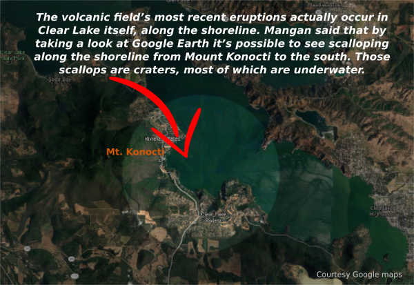
The volcanic field’s most recent eruptions about 11,000 years ago actually occurred in Clear Lake itself, along the shoreline. Mangan said that there were several of those “phreatic eruptions,” in which magma came up close to the surface of the earth and interacted with lake and groundwater, and produced steam explosions and rapid vaporization that created craters.
Mangan said that by taking a look at Google Earth it’s possible to see scalloping along the shoreline from Mount Konocti to the south. Those scallops are the craters, most of which are underwater, created by the phreatic eruptions.
In explaining the volcanic field, Mangan points out, “The Clear Lake Volcanic Field includes more than Mount Konocti.”
The other notables features that are of volcanic origin include areas where volcanic gases leaking out, which Mangan said is common.
Most of the magma that comes up to relatively shallow levels in the earth’s crust stays there. Mangan said it slowly cools and releases gas like what emerges at places like Sulphur Bank.
When a volcanologist talks of magma in the “near surface,” they mean 2 to 10 kilometers. For the Clear Lake Volcanic Field, Mangan said it’s around 6 kilometers.
There’s a pretty steady, low-level release of volcanic gases, most notably sulphur gases and carbon dioxide which originally was stored deep in the earth before being released from the magma and gradually making its way to the surface.
“It is a sign that the Clear Lake volcanic system isn’t done yet,” she said.
There also are areas on the lake like Soda Springs which people are warned to stay away from because of toxic gas emissions like carbon dioxide.
Mangan said carbon dioxide in water or snow can pond because it’s a dense gas. “You can build up some really big concentrations of C02, which is quite toxic to humans and other life forms.”
Since 2005, research and tracking of earthquakes, ground deformation and volcanic gas releases have shown that more research and monitoring are needed of the Clear Lake Volcanic Field, Mangan said. “It’s an important area of California.”
About two years ago, the California Volcanic Observatory started to shift some of its scientific research to the Clear Lake Volcanic Field, she said.
As a result, geophysical studies done in the past two years – in combination with work done in the 1970s and 1980s – shows that a zone of partially molten magma or rock exists under the field. As a result, they’re in the midst of additional research.
“We have a pretty robust research program going on in the Clear Lake area for the last two years,” she said. “We really need a better hazard zone map.”
They have a really good geologic map of the area which Mangan said can be used to create the volcano hazard zone map.
Mangan said they are working through the permitting process to add three more monitors in the Clear Lake Volcanic Field, which are expected to be in place in 2019 and 2020.
Before they can produce that hazard map and figure out where to put new monitoring equipment, they need to have a better understanding of what the current state of the volcanic system is, and where and how large are the zones of partially molten rock, Mangan said.
To do that, they’re using various types of geophysical measurements to provide a three-dimensional map of the subsurface of the Clear Lake Volcanic Field. One of the newest technologies for that purpose is magnetotellurics, which uses uses magnetism and electrical resistivity to map out zones where there are hot rock or partially molten rock below the surface.
The early results of the magnetotelluric survey are expected to come out sometime later this year, she said.
Another new technique they’re implementing is seismic tomography, which Mangan said uses seismometers to look at changes in seismic wave velocity.
When an earthquake happens and moves through the earth’s subsurface, those seismic waves will slow down in areas where there is partially molten or very hot rock. Mangan said that activity can be used to create surface images based on the seismic change velocity.
“We’re moving forward with the analysis of the current data that we’ve collected over the past two years, as well as adding new data to it. So it’s a work in progress,” she said, adding that it’s “one of the main ways to understand what’s underneath our feet up there.”
The USGS reported that its monitoring in the Clear Lake Volcanic Field and a collaborative effort with Calpine Corp. in The Geysers geothermal steam field provides real-time tracking of earthquake activity. In addition, the USGS periodically analyzes volcanic gases and hot springs in the region.
Mangan explained that The Geysers sits adjacent to the Clear Lake Volcanic Field on the western margin. “They are separate systems,” she said.
She added that what drives the geothermal system is hot rock and partially molten rock down deep in The Geysers region.
While people think about geothermal development and whether that production could impact a volcanic center, causing it to erupt, “It really is not the case,” said Mangan.
“The geothermal system is really shallow compared to the magmatic system,” she said, adding, “They’re just too far apart vertically.”
She said the Clear Lake Volcanic Field does have earthquakes, but they don’t happen often – only a few dozen a year – are usually below magnitude 2 and are deep, between 6 and 10 kilometers. That’s unlike the earthquakes in The Geysers, which are shallow and are the result of geothermal operations.
Increased monitoring planned
Mangan said volcano monitoring is essentially a three-legged stool, involving gathering data on earthquakes, ground deformation and gas emissions.
She said they have the seismicity and gas emissions covered pretty well, but don’t have ground deformation sensors in the field proper and want to increase overall monitoring. “We do need to increase our monitoring there.”
That’s why they plan to add three additional seismometers in 2019 or as late as 2020. It’s most important to have an adequate seismic network, which is the key type of sensor. “Right now it’s rather skeletal,” Mangan said of the monitoring system.
The California Volcanic Observatory has about 50 sensors, with four seismic sensors in the Clear Lake Volcanic Field, where Mangan said they want to fill in gaps, as it’s important to have a 360-degree arrangement in seismometers on a volcano.
Mangan said the new monitoring equipment already has been purchased. They just need to have their field engineers – who maintain the existing sensors – select the actual place on the ground to locate them.
Currently, monitoring equipment sends seismic data in real-time to the California Volcanic Observatory’s headquarters in Menlo Park. “That data is constantly streaming in,” Mangan said.
She said that if there’s anything unusual with respect to seismicity in the area, she’s attached to a beeper and she gets a notification.
At that point, she would interact with the observatory’s volcanologist to interpret that real-time monitoring.
Asked if that has happened for the Clear Lake Volcanic Field, Mangan said no, that so far nothing unusual has popped up.
Email Elizabeth Larson at This email address is being protected from spambots. You need JavaScript enabled to view it.. Follow her on Twitter, @ERLarson, or Lake County News, @LakeCoNews.
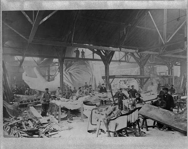
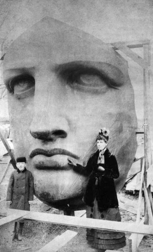
Workmen constructing the Statue of Liberty in Frederic Auguste Bartholdi's Parisian warehouse workshop; first model; left hand; and quarter-size head-. Possibly winter of 1882. Library of Congress Prints and Photographs Division Washington, D.C. 20540 USA http://hdl.loc.gov/loc.pnp/pp.print. On Oct. 28, 1886, President Grover Cleveland dedicated the Statue of Liberty on an island in New York Harbor, declaring, “We will not forget that Liberty has here made her home; nor shall her chosen altar be neglected.”
The president’s speech was just the end of a journey that stretched over two decades, encompassed two continents and spanned the Atlantic Ocean.
It had begun in the summer of 1865, when a group of men sat around a table in the suburbs of Paris. In attendance was Edouard Rene de Laboulaye, the owner of the house and a well-known author; noted historian Henri Martin; Oscar and Edmond de Lafayette, grandsons of the Marquis de Lafayette of American Revolution fame; and a young artist from the Alsace region, Frederic Auguste Bartholdi.
It was reportedly Laboulaye who first off-handedly remarked how wonderful it would be for France to present the American people with a monument to memorialize the friendship between the two nations, two sister republics and bastions of freedom. Although no action would be taken for some years, the idea of a monument germinated in the creative mind of the young artist Bartholdi, where it found fertile ground.
Following the disastrous 1870 conclusion to the Franco-Prussian War, the time seemed ripe for France to reconnect with America.
In 1871, the plan for the as-yet-unnamed monument was rejuvenated, with Laboulaye garnering support for the project at home and Bartholdi raising interest in America.
The artist attended dinner gatherings of wealthy socialites in New York City and elsewhere along the eastern seaboard. His marketing work paid off and it was decided that America would finance the construction of the pedestal and France that of the statue itself.
The plan was to erect the monument by July 4, 1876 – the centennial anniversary of the signing of the Declaration of Independence.
The iconic monument took form as a resolute lady liberty. In one hand she held a tablet bearing the date of July 4, 1776, in the other, a blazing torch of enlightenment. The statue’s symbolism, as well as its actual name, "Liberty Enlightening the World," reflected the emotions behind her formation. To the values of liberty, freedom and knowledge would Lady Liberty stand at the entrance to America, proclaiming their superiority over all others. Her very genealogy would be a testament to the deep kinship between France and America.
In her left hand, she held a tablet containing the date July 4, 1776 in Roman numerals. The seven rays of her crown represent the light of liberty shining across the seven seas and continents.
All in all, it was a spectacular monument, but an extraordinarily expensive one.
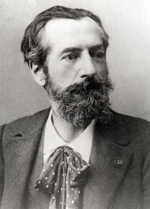
Frederic Auguste Bartholdi. Photo courtesy of the National Park Service. Despite raising a significant amount of money for both the pedestal and the actual statue, Lady Liberty arose from the heaps of bronze, copper and iron only incrementally.
Rather than unveiling her in all her glory on July 4, 1876, Bartholdi and his compatriots could only show her extended arm, clutching the torch.
They built the rest of Lady Liberty over the next eight years. When the French finally finished their part of the bargain in 1884, they looked to the Americans to uphold theirs.
With the ceremonial cornerstone laying on August 5, 1884, construction of the pedestal began in earnest.
It still took two years to complete. In that time, Lady Liberty had been disassembled into 350 pieces, packed into 214 crates aboard a French ship and unloaded in New York, only to wait while workers finished construction of her pedestal.
Rather than a hindrance to the project, the old star-shaped Fort Wood that had sat on the island for almost a century had been incorporated into Liberty’s base.
Finally, in 1886 all was ready for assembling her in her final place. The work proceeded rapidly and by Oct. 28, 1886 – just 10 years and three months late – Bartholdi himself drew back the French flag covering Liberty’s face to the sounds of whistles, the roar of guns and the applause of those below.
The Statue of Liberty, as the striking monument was popularly nicknamed, stood 151 feet tall. Bartholdi had designed the statue, but Gustave Eiffel, who had built the Eiffel Tower in Paris (which would be unveiled several months later) had designed the structural metal skeleton. Although first envisioned as a monument to democracy and enlightenment, the symbolism of the statue evolved with the nation.
When, in 1903, officials placed a bronze plaque bearing Emma Lazarus’ now-famous poem, "The New Colossus," Liberty became an emblem of America’s promise to the world’s poor. With her austere gaze, she commanded the entry into the port of New York.
She still stands there today, a testament to the value of freedom so greatly cherished by the democracies that birthed her. "Give me your tired, your poor; Your huddled masses yearning to breathe free… I lift my lamp beside the golden door!"
Antone Pierucci is curator of history at the Riverside County Park and Open Space District and a freelance writer whose work has been featured in such magazines as Archaeology and Wild West as well as regional California newspapers.
Unpacking the head of the Statue of Liberty. Public domain photo.
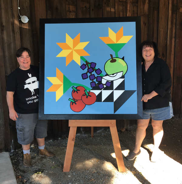
Dancing Poly's Basket has joined the Lake County Quilt Trail in Lake County, Calif. Shown here are Bess Giannakakis and Blaise Bahara. Photo courtesy of the Lake County Quilt Trail. LAKEPORT, Calif. – “Dancing Poly’s Basket” is the latest quilt block on the Lake County Quilt Trail.
It’s located at Dancing Poly Farm & Food, located at 2550 Soda Bay Road, Lakeport.
This 4-foot by 4-foot quilt block joining the Lake County Quilt Trail, which now has more than 100 blocks, belongs to Blaise Bahara and Bess Giannakakis, owners, founders and food experts of Dancing Poly Farms.
Bahara and Giannakakis offer their abundance of culinary skills, years of professional food, hospitality and business experience through lessons and demonstrations at their farm.
They also travel the county offering catering at local farmers markets and other Lake County events, such as the Pear Festival and Wine & Chocolate.
The Lake County Quilt Trail is an agricultural and tourism project designed to promote community pride.
The quilt block was drawn and painted by the Lake County Quilt Trail team, a group of dedicated volunteer quilters, graphic artists, painters, writers and carpenters.
LAKE COUNTY, Calif. – Lake County Animal Control has a mix of big and little dogs waiting for new homes this week.
Dogs available for adoption this week include mixes of American Bulldog, Australian Shepherd, Chihuahua, German Shepherd, hound, Labrador Retriever, McNab, miniature pinscher, Pekingese, pit bull, terrier and Shiba Inu.
Dogs that are adopted from Lake County Animal Care and Control are either neutered or spayed, microchipped and, if old enough, given a rabies shot and county license before being released to their new owner. License fees do not apply to residents of the cities of Lakeport or Clearlake.
If you're looking for a new companion, visit the shelter. There are many great pets hoping you'll choose them.
The following dogs at the Lake County Animal Care and Control shelter have been cleared for adoption (additional dogs on the animal control Web site not listed are still “on hold”).
This male terrier mix is in kennel No. 2, ID No. 11286. Photo courtesy of Lake County Animal Care and Control. Male terrier mix
This male terrier mix has a long white coat.
He’s in kennel No. 2, ID No. 11286.
“Lucky” is a senior dog in kennel No. 4a, ID No. 11274. Photo courtesy of Lake County Animal Care and Control. ‘Lucky’
“Lucky” appears to be a miniature pinscher mix.
He is a senior with a short black and brown coat.
He’s already been neutered.
Lucky is in kennel No. 4a, ID No. 11274.
“Pookey” is a male Pekingese-Chihuahua mix in kennel No. 4b, ID No. 11273. Photo courtesy of Lake County Animal Care and Control. ‘Pookey’
“Pookey” is a male Pekingese-Chihuahua mix.
He already has been neutered and has a medium-length tan coat.
He’s in kennel No. 4b, ID No. 11273.
This female pit bull terrier is in kennel No. 5, ID No. 11287. Photo courtesy of Lake County Animal Care and Control. Female pit bull terrier
This female pit bull terrier has a short brindle coat.
She already has been spayed.
She is in kennel No. 5, ID No. 11287.
This male pit bull is in kennel No. 6, ID No. 11224. Photo courtesy of Lake County Animal Care and Control. Male pit bull
This male pit bull has a short brindle coat.
He already has been neutered.
He’s in kennel No. 6, ID No. 11224.
“Crow” is a male pit bull terrier in kennel No. 7, ID No. 11275. Photo courtesy of Lake County Animal Care and Control. ‘Crow’
“Crow” is a male pit bull terrier with a short black and white coat.
He already has been neutered.
He’s in kennel No. 7, ID No. 11275.
This male terrier is in kennel No. 8, ID No. 11293. Photo courtesy of Lake County Animal Care and Control. Male terrier
This male terrier has a short white and tan coat.
He’s in kennel No. 8, ID No. 11293.
This male Labrador Retriever is in kennel No. 11, ID No. 11257. Photo courtesy of Lake County Animal Care and Control. Male Labrador Retriever
This male Labrador Retriever has a short black coat with white markings.
He’s in kennel No. 11, ID No. 11257.
This female Shiba Inu mix is in kennel No. 19, ID No. 11198. Photo courtesy of Lake County Animal Care and Control. Shiba Inu mix
This female Shiba Inu mix has a short red and brown coat.
She already has been spayed.
She’s in kennel No. 19, ID No. 11198.
This female pit bull terrier is in kennel No. 22, ID No. 11192. Photo courtesy of Lake County Animal Care and Control. Female pit bull terrier
This female pit bull terrier has a short brown coat.
She’s in kennel No. 22, ID No. 11192.
This female pit bull terrier is in kennel No. 23, ID No. 10226. Photo courtesy of Lake County Animal Care and Control. Female pit bull terrier
This female pit bull terrier has a short brown coat.
She already has been spayed.
She’s in kennel No. 23, ID No. 10226.
“Saint” is a male American Bulldog-pit bull terrier mix in kennel No. 24, ID No. 11236. Photo courtesy of Lake County Animal Care and Control. ‘Saint’
“Saint” is a male American Bulldog-pit bull terrier mix.
He has a short blue and brindle coat.
He’s in kennel No. 24, ID No. 11236.
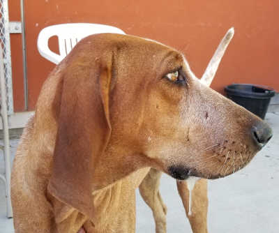
This female hound is in kennel No. 26, ID No. 11116. Photo courtesy of Lake County Animal Care and Control. Female hound
This female hound has a brown and white coat.
She already has been spayed.
She’s in kennel No. 26, ID No. 11116.
This male German Shepherd mix is in kennel No. 28, ID No. 11223. Photo courtesy of Lake County Animal Care and Control. Male German Shepherd mix
This male German Shepherd mix has a short brown and black coat.
He already has been neutered.
He’s in kennel No. 28, ID No. 11223.
This female Australian Shepherd is in kennel No. 30, ID No. 11152. Photo courtesy of Lake County Animal Care and Control. Female Australian Shepherd
This female Australian Shepherd has a short brindle and white coat.
She has already been spayed.
She’s in kennel No. 30, ID No. 11152.
This male terrier-McNab mix is in kennel No. 33, ID No. 11211. Photo courtesy of Lake County Animal Care and Control. Male terrier-McNab mix
This male terrier-McNab mix has a short black coat.
He’s in kennel No. 33, ID No. 11211.
Lake County Animal Care and Control is located at 4949 Helbush in Lakeport, next to the Hill Road Correctional Facility.
Office hours are Monday through Friday, 11 a.m. to 5 p.m., and 11 a.m. to 3 p.m., Saturday. The shelter is open from 11 a.m. to 4 p.m. Monday through Friday and on Saturday from 11 a.m. to 3 p.m.
For more information call Lake County Animal Care and Control at 707-263-0278.
Email Elizabeth Larson at This email address is being protected from spambots. You need JavaScript enabled to view it. . Follow her on Twitter, @ERLarson, or Lake County News, @LakeCoNews.
Lightning is as beautiful as it is powerful – a violent, hotter than the surface of the sun electrical marvel. But might lightning on other planets be even more astonishing?
Consider this. When Voyager 1 flew by Jupiter in 1979, its imager captured areas nearly as big as the U.S. lit up by lightning in Jupiter’s clouds.
Voyager also captured other, less ‘flashy’ signs of lightning. University of Iowa physicist Don Gurnett is one of the scientists whose Voyager instrument detected radio waves called whistlers -- signs of lightning.
New Horizons cameras captured lightning flashes on Jupiter ten times as powerful as anything ever recorded on Earth.
And recently Juno, flying closer to Jupiter than any previous mission, found that most of Jupiter’s lightning is around the planet’s higher latitudes, unlike Earth, where lightning strikes primarily over land and most intensely at the equator. Juno detected peak rates of four strikes per second -- similar to rates on Earth.
On Earth, lightning forms because colliding ice crystals and water drops inside clouds create positive and negative electric charges which become separated by convective forces. When the charges become separated enough, a lightning bolt discharges. Something similar happens on Jupiter. Gases, including water vapor, rise from deep within the planet. As they freeze, ice particles become separated from the water drops by convection, building a charge, which is discharged as lightning.
Lightning has also been observed on gas giant Saturn. In 1980-81, Voyager detected radio signals called sferics, which like whistlers are signs of lightning.
Gurnett says, “On Earth, you can hear these high-frequency radio emissions on your car’s AM radio as ‘radio static’ during a nearby lightning storm.”
Cassini recorded similar emissions at Saturn, revealing that, for strong storms, lightning occurred as many as ten times per second!
Gurnett has been involved in the search for lightning on other planets across the solar system as well.
Venus, for example, has a hot, dry atmosphere made up mostly of carbon dioxide suffused with sulfuric acid. Could this brew become electrically charged and generate lightning? When Cassini flew by Venus twice in 1998 and 1999 Gurnett did a search for lightning with a radio instrument perfect for detecting signs of lightning sferics. However the instrument picked up no signs at all. That same instrument easily detected sferics during a similar flyby of Earth two months later, leading him to believe that there is no Earth-like lightning present on Venus.
The European Space Agency’s Venus Express orbiter has picked up bursts of electromagnetic waves some scientists attribute to whistlers, but others argue that the instrument’s frequency range was too low to detect the usual forms of whistlers.
Gurnett has used Mars Express’s radar system receiver to conduct a five year search for lightning associated with dust storms on Mars. That search didn’t find lightning, however, images from the Mars Global Surveyor show bright flashes in dust storms, as well as craters on Mars that some scientists believe to be evidence of lightning strikes on the planet’s surface.
Pictured, clockwise, from top left, Joshua Billy Holden, 24, Jocia Nicole McCloskey, 34, of Clearlake, George Meszaros, 32, and Maranda Dawn Medina, 38, all of Clearlake, Calif., are suspects in a forgery case in Lake County, Calif.
LAKE COUNTY, Calif. – The Lake County Sheriff’s Office is currently conducting an investigation related to several forged checks that have been used within Lake County.
Lt. Corey Paulich said the suspects have been identified as Joshua Billy Holden, 24, of Clearlake; George Meszaros, 32, of Clearlake; Maranda Dawn Medina, 38, of Clearlake; and Jocia Nicole McCloskey, 34, of Clearlake.
The suspects made fictitious checks that were made to look as if they were issued to them from Rainbow Ag and the Travelodge in Clearlake as well as other businesses outside of Lake County, Paulich said.
Paulich said that on Oct. 19, deputies – with the assistance of officers from the Clearlake Police Department, conducted a probation search at Meszaros’ residence on Eureka Avenue in Clearlake.
Holden was located and arrested at the residence. Paulich said deputies located several items of evidence confirming the suspect’s involvement with the forged checks.
Meszaros, Medina and McCloskey are believed to have fled Lake County. Paulich said Meszaros is currently on probation related to drug offenses.
Medina is on post release community supervision probation, or PRCS, for drug and weapons offenses and has an active warrant for violating that probation, Paulich said.
Paulich said the case was forwarded to the District Attorney’s Office and arrest warrants were issued for Meszaros, Medina and McCloskey.
The sheriff’s office believes there may be more unreported cases related to the forgeries, Paulich said.
If you are a victim please file a report with the law enforcement agency responsible for your location. If you are located in the city of Lakeport or the unincorporated areas of the county you can contact Central Dispatch at 707-263-2690.
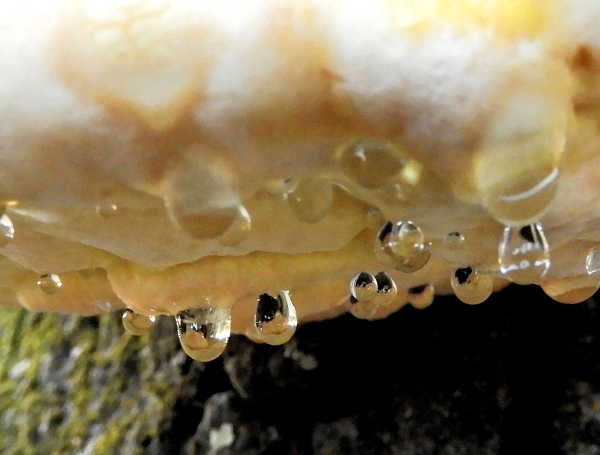
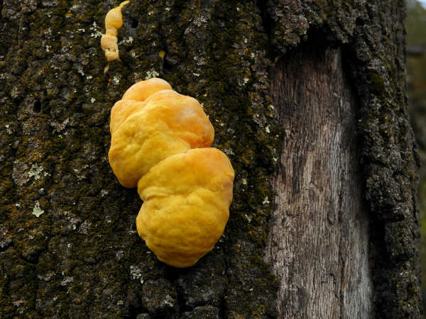
These droplets of nearly clear liquid aren’t dew; they’re actually beads of excess moisture the fungus exudes when its growing. The phenomenon, known as guttation, is common in plants, but less understood in fungi although many forms of fungi do exhibit it. Photo by Mary K. Hanson. NORTHERN CALIFORNIA – Before most of the other fungi make their appearance in the Berryessa Snow Mountain National Monument region, specimens of sulphur shelf fungus (Laetiporus gilbertsonii) appear like bright yellow-orange halos on the sides of trees.
They’re unmistakable, large and very colorful.
Different species of sulphur shelf fungus used to be lumped under the old classification name of Laetiporus sulphureus, but in 2001 they were separated out into their own distinct classifications based on DNA evidence.
Laetiporus gilbertsonii is the one we find in California, mostly growing on hardwoods like oaks and eucalyptus trees. There’s another species in California called Laetiporus conifericola that grows on conifers trees like fir and redwoods.
The fungus can grow on any part of the tree, from the base to the high trunk, wherever its spores have settled in. Most often, it is found on dead or dying trees. It’s a kind of “saprotroph,” which means it’s a decomposer, getting nutrients from decaying organic matter. But it’s also considered a “weak parasite” that can also grow on living trees and slowly sap nutrients from them.
Sulphur shelf doesn’t like it when it’s very wet outside, so it usually shows up around October or November before the rainy season starts. At first, you don’t see the fungus at all as it’s living inside the tree and bark, doing its thing as a web of tiny hair-like mycelium. When the fruiting body of the fungus finally emerges onto the surface of the tree, it looks like small yellow-orange swellings that over a period of a few days turn into larger lumps with lobes, like small brains.
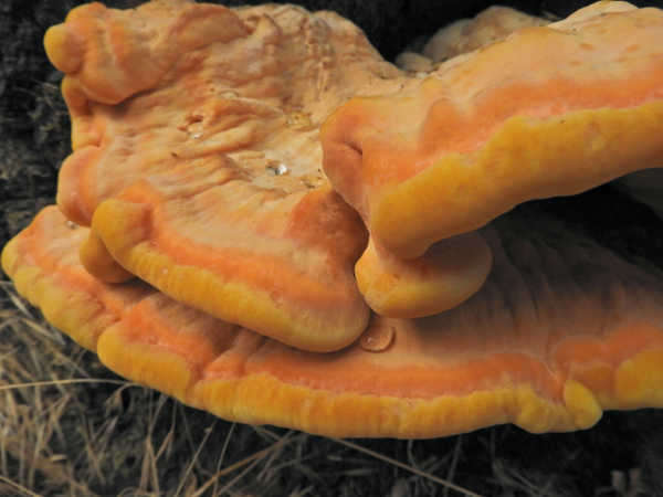
In about a week the lobes expand, thin out, and stretch into half-moon shaped shelf-like structures. Sometimes you’ll see a single shelf; sometimes the shelves are stacked up one on top of the other in groups of two to 12 or more.
The shelves are somewhat thick and fleshy and feel something like cork. Sulphur shelf is a kind of bracket polypore, so if you look at the underside of the shelves you’ll see their surfaces are riddled with hundreds of tiny pores. It’s in these pores that the fungus’s white spores are produced.
You may also see what look like tears or sweat coming from the fungus. These droplets of nearly clear liquid are actually beads of excess moisture the fungus exudes when its growing.
The phenomenon, known as guttation, is common in plants, but less understood in fungi although many forms of fungi do exhibit it. In some fungi, this guttation can appear as clear sweat, as it does in sulphur shelf, or as black, orange or even red tears (as in the Bleeding Tooth fungus, Hydnellum peckii.)
When the fruiting body of the fungus finally emerges onto the surface of the tree, it looks like small yellow-orange swellings that over a period of a few days turn into larger lumps with lobes, like small brains. Photo by Mary K. Hanson. As the sulphur shelf fungus ages, it loses its bright yellow-orange coloring and all evidence of guttation vanishes. It turns dry, chalky white and can crumble in your hand.
Sulphur shelf is known by many different common names including crab of the woods and chicken of the forest, which reflect its supposedly edible nature. Some say it tastes like chicken, others say it tastes like lobster.
Old chalky specimens are inedible, however, so stick to the bright, young ones that show a lot of guttation if you’re inclined to try a sample. Keep in mind, however, that whether the fungus is truly, safely, completely edible is widely disputed.
Some reports suggest that much depends on what sort of substrate of the fungus is growing on. If it’s growing on oak trees, for example, it’s supposed to be more edible than specimens growing on conifers or eucalyptus trees.
Other studies suggest that it’s edible, no matter what the substrate, but can cause mild to severe gastrointestinal distress in people who are sensitive to it.
Regardless, all of the studies say that the chicken of the forest – as is true of the barnyard fowl – should never be eaten raw (sautéing it or boiling it are suggested). And if you’re not sure about your level of sensitivity to fungi in general, you shouldn’t risk your health by trying it out.
Maybe the best way to enjoy this large, beautiful, native fungus is just to take photos of it and leave it where it is.
Mary K. Hanson is a Certified California Naturalist, author, nature photographer and blogger (https://chubbywomanwalkabout.com/). She also teaches naturalist classes through Tuleyome, a501(c)(3) nonprofit conservation organization based in Woodland, Calif. For more information, visit www.tuleyome.org .
After emerging, the fungus stretches out into half-moon shaped shelf-like structures. Sometimes you’ll see a single shelf; sometimes the shelves are stacked up one on top of the other in groups of two to twelve or more. It’s at this stage when the Sulphur Shelf is most edible. Be aware, however, that it should never be eaten raw and should be avoided by people who are sensitive to fungi. Photo by Mary K. Hanson.
Oct. 24 to 31 is Bat Week, an annual, international celebration of the role bats play in the natural world.
Bats are truly amazing creatures. There are more than 1,400 species of bats in the world, about 20 percent of all mammal species.
About two-thirds of bats are insectivorous. They consume between 50 and 100 percent of their own weight every night. They protect our food crops and timber industry-worth more than $57 billion per year-and if it weren't for bats, farmers would surely use more chemical pesticides than they do now.
Nationwide, the service bats provide by suppressing insect populations has been estimated worth something between $4 billion and $50 billion per year to American agriculture.
CDFW Senior Environmental Scientist Scott Osborn notes, "Even the low end of that broad estimate, $4 billion, is an impressive amount. Bats are an important part of integrated pest management systems."
Some bat species pollinate many species of plants throughout the world, including agave, the main ingredient in tequila. Even their guano (feces) is valuable. It provides rich fertilizer across the landscape and is important for cave ecosystems. Without bats, the invertebrates and microorganisms that live in caves and depend on bat guano-and the amphibians that depend on them-couldn't thrive.
Bats have contributed to human well-being in other ways, too. Stroke victims have been saved by a synthesized anti-clotting enzyme found in bat spit. Research conducted on bats has also led to advancements in vaccine development, sonar, and more.
Unfortunately, population declines have caused 17 of California's 25 native bat species to receive some level of state or federal protection.
In eastern North America, white-nose syndrome, or WNS, has killed more than six million bats. It is caused by a fungus-Pseudogymnoascus destructans-that grows in and on bats' skin during winter hibernation and spreads quickly through bat colonies.
The 2016 discovery of a bat with WNS in the State of Washington suddenly brought this unprecedented wildlife health crisis close to home.
The fungus has since been found at more sites in Washington. CDFW and its partners continue to do surveillance and response planning for the disease, which almost inevitably will be here in California before long.
Bats need our help. You can be a hero for bats by joining in the celebrations during Bat Week 2018 and beyond.
Things a bat hero can do:
– Learn more about bats and teach others about how important they are; – Take action to help protect bats and their habitat; – If you drink tequila, keep an eye out for bat-friendly brands; – Build and install a bat box on your property; – Add bat-friendly plants to your garden; or – Join a citizen-science bat monitoring project in your area.
There are many ideas for how you can be a Bat Hero at the Bat Week 2018 Web site, http://batweek.org. Look under the "Take Action" tab.
Gov. Edmund G. Brown Jr. also has issued a letter regarding Bat Week 2018, which can be seen here.
California Governor Edmund G. Brown Jr. on Friday announced the appointment of Gabriel P. Sanchez as associate justice, Division One, Carin T. Fujisaki as associate justice, Division Three and Justice Stuart R. Pollak as presiding justice, Division Four of the First District Court of Appeal; Peter A. Krause as associate justice of the Third District Court of Appeal; and Frank J. Menetrez as associate justice, Division Two of the Fourth District Court of Appeal.
Gabriel P. Sanchez. Courtesy photo. First District Court of Appeal, Division One
Gabriel P. Sanchez, 42, of Oakland, has been appointed associate justice, Division One of the First District Court of Appeal.
Sanchez has served as a deputy legal affairs secretary in the Office of Governor Edmund G. Brown Jr. since 2012. He served as a deputy attorney general at the California Department of Justice, Office of the Attorney General from 2011 to 2012 and was an associate at Munger, Tolles and Olson LLP from 2006 to 2011. He served as a law clerk for the Honorable Richard A. Paez at the U.S. Court of Appeals, Ninth Circuit from 2005 to 2006.
He earned a Juris Doctor degree from Yale Law School, a Master of Philosophy degree from the University of Cambridge and a Bachelor of Arts degree from Yale College.
Sanchez will fill the vacancy created by the retirement of Justice Robert L. Dondero effective October 31, 2018.
This position requires confirmation by the Commission on Judicial Appointments. The commission consists of Chief Justice Tani Cantil-Sakauye, Attorney General Xavier Becerra and Senior Presiding Justice J. Anthony Kline. Subject to being confirmed, Sanchez plans to continue serving in his current position in the Governor’s Office until the end of the year.
He will be the first male Latino justice ever appointed to the First District Court of Appeal, if confirmed.
Sanchez is a Democrat.
Carin T. Fujisaki. Courtesy photo. First District Court of Appeal, Division Three
Carin T. Fujisaki, 59, of Walnut Creek, has been appointed associate justice, Division Three of the First District Court of Appeal.
Fujisaki has served as principal attorney to the chief justice at the California Supreme Court since 2015, where she was a judicial staff attorney from 1991 to 2014 and a staff attorney from 1990 to 1991.
She was an associate at Howard, Rice, Nemerovski, Canady, Robertson and Falk from 1986 to 1990 and a research attorney at the San Francisco County Superior Court from 1985 to 1986.
Fujisaki earned a Juris Doctor degree from the University of California, Hastings College of the Law and a Bachelor of Arts degree from the University of California, Los Angeles.
She fills the vacancy created by the elevation of Justice Peter J. Siggins to presiding justice, Division Three of the First District Court of Appeal.
This position requires confirmation by the Commission on Judicial Appointments. The Commission consists of Chief Justice Tani Cantil-Sakauye, Attorney General Xavier Becerra and Senior Presiding Justice J. Anthony Kline.
Fujisaki is a Democrat.
Justice Stuart R. Pollak. Courtesy photo. First District Court of Appeal, Division Four
Stuart R. Pollak, 81, of San Francisco, has been appointed presiding justice, Division Four of the First District Court of Appeal.
Pollak has served as an associate justice in Division Three of the First District Court of Appeal since 2002.
He served as a judge at the San Francisco County Superior Court from 1982 to 2002 and held several positions at Howard, Rice, Nemerovski, Canady and Pollak from 1965 to 1982, including partner and associate.
He served as an attorney at the U.S. Department of Justice from 1963 to 1966 and served as a law clerk for the Honorable Earl Warren, the Honorable Stanley Reed and the Honorable Harold Burton at the U.S. Supreme Court from 1962 to 1963.
Pollak earned a Juris Doctor degree from Harvard Law School and a Bachelor of Arts degree from Stanford University.
He fills the vacancy created by the retirement of Presiding Justice Ignazio J. Ruvolo. This position requires confirmation by the Commission on Judicial Appointments. The Commission consists of Chief Justice Tani Cantil-Sakauye, Attorney General Xavier Becerra and Senior Presiding Justice J. Anthony Kline.
Pollak is a Democrat.
Peter A. Krause. Courtesy photo. Third District Court of Appeal
Peter A. Krause, 49, of Sacramento, has been appointed associate justice of the Third District Court of Appeal.
Krause has served as legal affairs secretary in the Office of Governor Edmund G. Brown Jr. since 2014, where he was chief deputy legal affairs secretary from 2013 to 2014.
He served in several positions at the California Department of Justice, Office of the Attorney General from 2007 to 2013, including supervising deputy attorney general and deputy attorney general.
Krause was an attorney at the Judicial Council of California, Office of the General Counsel from 2005 to 2007 and an associate at Sheppard, Mullin, Richter and Hampton from 1996 to 2005.
He earned a Juris Doctor degree from Loyola Law School, Los Angeles and a Bachelor of Arts degree from the University of California, Berkeley. He fills the vacancy created by the retirement of Justice George W. Nicholson.
This position requires confirmation by the Commission on Judicial Appointments. The Commission consists of Chief Justice Tani Cantil-Sakauye, Attorney General Xavier Becerra and Presiding Justice Vance W. Raye.
Subject to being confirmed, Krause plans to continue serving in his current position in the Governor’s Office until the end of the year.
Krause is registered without party preference.
Frank J. Menetrez. Courtesy photo. Fourth District Court of Appeal
Frank J. Menetrez, 52, of Claremont, has been appointed associate justice, Division Two of the Fourth District Court of Appeal.
Menetrez has served as a judge at the Los Angeles County Superior Court since 2015. He served as an appellate judicial attorney at the Second District Court of Appeal from 2005 to 2015. He was an associate at Horvitz and Levy from 2004 to 2005 and at Sidley Austin from 2001 to 2004. Menetrez served as a law clerk for the Honorable A. Wallace Tashima at the U.S. Court of Appeals, Ninth Circuit from 2000 to 2001.
He earned a Juris Doctor degree from the University of California, Los Angeles School of Law, Doctor of Philosophy and Master of Arts degrees from the University of California, Los Angeles and a Bachelor of Arts degree from Johns Hopkins University.
He fills the vacancy of a new position created on July 1, 2018.
This position requires confirmation by the Commission on Judicial Appointments. The Commission consists of Chief Justice Tani Cantil-Sakauye, Attorney General Xavier Becerra and Senior Presiding Justice Manuel A. Ramirez.
Menetrez is a Democrat.
The compensation for each of these positions is $228,918.
What does our planet look like from space? Most are familiar with beloved images of the blue marble or pale blue dot – Earth from 18,000 and 3.7 billion miles away, respectively.
But closer to home, at the boundary between Earth and space, you might encounter an unfamiliar sight.
If you were to peer down on Earth from just 300 miles above the surface, near the orbit of the International Space Station, you could see vibrant swaths of red and green or purple and yellow light emanating from the upper atmosphere.
This light is airglow.
Airglow occurs when atoms and molecules in the upper atmosphere, excited by sunlight, emit light to shed their excess energy. Or, it can happen when atoms and molecules that have been ionized by sunlight collide with and capture a free electron.
In both cases, they eject a particle of light – called a photon – in order to relax again. The phenomenon is similar to auroras, but where auroras are driven by high-energy particles originating from the solar wind, airglow is energized by ordinary, day-to-day solar radiation.
Unlike auroras, which are episodic and fleeting, airglow constantly shines throughout Earth’s atmosphere, and the result is a tenuous bubble of light that closely encases our entire planet. (Auroras, on the other hand, are usually constrained to Earth’s poles.)
Just a tenth as bright as all the stars in the night sky, airglow is far more subdued than auroras, too dim to observe easily except in orbit or on the ground with clear, dark skies and a sensitive camera. But it’s a marker nevertheless of the dynamic region where Earth meets space.
Stretching from roughly 50 to 400 miles above the surface, this region, called the ionosphere, is an electrified layer of the upper atmosphere, cooked by extreme ultraviolet radiation from the Sun until molecules break apart, giving rise to a mix of charged ions and electrons.
It’s neither fully Earth nor fully space, and instead, reacts to both terrestrial weather – the weather we experience on Earth – rippling up from below and solar energy streaming in from above, forming a complex space weather system of its own.
Turbulence in this ever-changing sea of charged particles can manifest as disruptions that interfere with orbiting satellites or communication and navigation signals used to guide airplanes, ships and self-driving cars.
Understanding the ionosphere’s extreme variability is tricky because it requires disentangling interactions between the different factors at play – interactions of which we don’t have a clear picture. That’s where airglow comes in.
“Each atmospheric gas has its own favored airglow color depending on the gas, altitude region, and excitation process, so you can use airglow to study different layers of the atmosphere,” said Doug Rowland, an astrophysicist at NASA’s Goddard Space Flight Center in Greenbelt, Maryland. “We’re not studying airglow per se, but using it as a diagnostic.”
Airglow carries information on the upper atmosphere’s temperature, density, and composition, but it also helps us trace how particles move through the region itself.
Vast, high-altitude winds sweep through the ionosphere, pushing its contents around the globe – and airglow’s subtle dance follows their lead, highlighting global patterns.
Two NASA missions take advantage of our planet’s natural glow to study the upper atmosphere: ICON, short for Ionospheric Connection Explorer, and GOLD — Global-scale Observations of the Limb and Disk.
ICON focuses on how charged and neutral gases in the upper atmosphere interact, while GOLD observes what’s driving change – the Sun, Earth’s magnetic field or the lower atmosphere – in the region.
By watching and imaging airglow, the two missions enable scientists to tease out how Earth’s weather and space intersect, dictating the region’s complex behavior.
Lina Tran works for NASA’s Goddard Space Flight Center in Greenbelt, Md.
LAKE COUNTY, Calif. – County officials reported this week that the work to clean up properties damaged by the Pawnee and Mendocino Complex fires is continuing.
On Tuesday, the Board of Supervisors approved requests from Lake County Public Health officials to continue proclamations of local emergencies for both the Pawnee fire and Mendocino Complex due to the health hazards that remain because the cleanup is not complete.
Lake County Environmental Health Director Jesse Kang told the board that, as of Oct. 20, debris removal was completed on five parcels out of 12 for the Pawnee fire.
For the Mendocino Complex, Kang said that as of Oct. 20 153 rights-of-entry forms had been submitted by property owners to participate in the state-sponsored cleanup program.
Of those, debris removal had been completed for 44 sites through the state program, seven sites were approved for private cleanup and 13 were approved for modified cleanup, which he said was for outbuildings or barns.
The California Department of Toxic Substances Control is one of the agencies involved in the state cleanup program.
Its Emergency Response Program is assessing and sweeping household hazardous waste and easily transferable pieces of asbestos from homes and other structures destroyed by the Mendocino Complex.
As of early Friday, the agency said that 198 parcels had been assessed and, of those, 190 were identified by the county of Lake and Cal Fire as having been damaged by the fire.
The map above was created using a list of damaged properties created by Cal Fire. About two dozen properties are not shown on this version of the map due to incomplete addresses that the mapping program would not recognize.
Email Elizabeth Larson at This email address is being protected from spambots. You need JavaScript enabled to view it.. Follow her on Twitter, @ERLarson, or Lake County News, @LakeCoNews.

 How to resolve AdBlock issue?