CLEARLAKE, Calif. – Clearlake Police officers on Friday morning were able to safely detain a man found armed with two knives.
The officers encountered the man – whose name is not being released – when they responded to a call just after 8:15 a.m. Friday, according to a report from Sgt. Rodd Joseph.
Joseph said officers responded to the 6100 block of Old Highway 53 on a report of a man holding a knife to his own chest. A passerby had called 911 after spotting the man, but had no other information on the subject.
Officers arrived and located the subject in the wooded dry creek area to the rear of the Cedar Village Apartment complex. Joseph said the subject was holding a large knife in one hand and had a second large knife pressed into his upper chest.
Initially the man was noncommunicative with officers who worked on establishing rapport with the man, Joseph said.
Joseph said that, after a short while, officers were able to convince the man to drop one of the knives, but the man kept the other pressed into his chest.
Lake County Behavioral Health social workers arrived on scene and continued building rapport with the distraught man, Joseph said.
After about a 20-minute standoff, the man dropped the other knife he was holding and safely surrendered to officers on scene. Joseph said the man was transported to Adventist Health Clear Lake for a mental health evaluation.
The Clearlake Police Department thanked the Lake County Sheriff’s Office, the California Highway Patrol and Lake County Behavioral Health Services for their immediate assistance in helping resolve a potentially dangerous situation.
Norman the Slug with the Silly Shell explores ways to fit in. Norman wants to be a snail but slugs lack shells, so he tries to find a shell for himself with hilarious results. This book is one of the titles featured at upcoming Little Read storytimes at all Lake County Library branches as part of the NEA Big Read in Lake County, Calif. Courtesy image. LAKE COUNTY, Calif. – The Lake County Library is celebrating the National Endowment for the Arts Big Read this month and wants to let the public know that the NEA Big Read isn’t just for adults.
Children can join in the action with the companion Little Read picture book titles that touch on the same themes explored in the novel selection.
“Brave” by Stacy McAnulty was chosen for the theme of being courageous. “Pancho Rabbit and the Coyote: A Migrant's Tale” by Duncan Tonatiuh was chosen for its description of immigration. “Norman the Slug with the Silly Shell” by Sue Hendra was chosen because it deals with what it means to belong.
In October each branch of the Lake County Library will host a Little Read storytime featuring the Little Read picture books as part of the NEA Big Read.
Middletown Library’s Little Read will be Tuesday, Oct. 9, at 11:30 a.m. at 21256 Washington St.
Upper Lake Library will hold its Little Read on Wednesday, Oct. 10, at 2:30 p.m. at 310 Second St.
Redbud Library at 14785 Burns Valley Road in Clearlake will have a Little Read on Thursday, Oct. 11, at 10:30 a.m.
The final Little Read storytime will be at Lakeport Library 1425 N High St. on Friday, Oct. 12 at 10:15 a.m.
Joy Fay and Kathy Perkins, teachers from Burns Valley Elementary School, selected three Little Read companion books for the classrooms.
Copies of the books have been donated to all Lake County elementary schools so teachers can participate in The NEA Big Read with their classrooms.
NORTHERN CALIFORNIA – Caltrans will begin more than 120 new “Fix-it-First” projects this fiscal year, replacing, repairing and improving more than 6,700 lane miles of pavement, 250 culverts and 320 bridges across the state, due to funds from Senate Bill 1, the Road Repair and Accountability Act of 2017.
These projects got the green light after the department received almost half a billion dollars of SB 1 funding for new state highway maintenance projects this fiscal year.
“Without the funds from SB 1, some of these projects would be postponed, costing taxpayers a lot more money down the road,” said Caltrans Director Laurie Berman. “It would be like putting Band-Aids on our roads and bridges instead of the long-term repair and repaving projects provided by SB 1.”
Caltrans is planning to use about $400 million in SB 1 funds for new maintenance projects to replace, repair and improve the existing state highway, bridges and drainage systems.
Work includes repairing the state highway by eliminating cracks and potholes on roadways; replacing pavement; performing preventative maintenance work to preserve bridges and roads; replacing and repairing culverts/drainage systems to prevent flooding on roadways; widen striping size from 4 to 6 inches on roads to increase safety and visibility for motorists. See the attached list for more details.
In Lake and Mendocino counties, the funds will pay for a striping project that will take place on Highways 20 and 53.
The $4.6 million project will widen striping and increase visibility on 263 lane miles of Highway 20 at various locations from U.S. Highway 101/SR-20 separation in the city of Ukiah in Mendocino County to the Lake/Colusa County line, Highway 29 at various locations from the Napa/Lake County line to east of Konocti Rock Company Road in the town of Kelseyville and from east of Cole Creek Road in Kelseyville to Highway 20 Junction in the town of Upper Lake in Lake County, and Highway 53 at various locations from Main Street in the town of Lower Lake to Highway 20 junction in the town of Clearlake Oaks in Lake County.
Other regional projects include:
– Bridge project on State Routes 1 and 128 in Mendocino County: $1.7 million bridge preservation project will revamp bridges on Highway 1 at various locations from Schooner Gulch Bridge in the city of Point Arena to Caspar Creek Bridge in Mendocino County, and SR-128 at Anderson Creek Bridge in the town of Boonville in Mendocino County.
– Striping project on U.S. Highway 199 and Highway 299 in Del Norte and Humboldt counties: $3.1 million project will widen striping and increase visibility on 178 lane miles of U.S. Highway 199 at various locations from US-101 Junction in Crescent City in Del Norte County to the California/Oregon State line, and State Route 299 at various locations from SR-299/US-101 separation in the city of Arcata to north of Titlow Hill Road in the city of Blue Lake, and from west of Willow Glen/Willow Road to south of New 3 Creeks Road in the town of Willow Creek in Humboldt County.
Since the passage of SB 1, Caltrans has used SB 1 funds to accelerate more than 120 maintenance projects across the state.
So far, Caltrans has completed 42 SB 1 funded maintenance projects, replacing more than 600 lane miles of state highway and improving 33 bridges.
By the end of this calendar year, Caltrans is expected to improve an additional 178 bridges and repair or replace an additional 1,200 lane miles.
For a complete list and to see an interactive map of SB 1 state and local projects, visit http://www.rebuildingca.ca.gov/ .
SB 1 provides an ongoing funding increase of approximately $1.8 billion annually for the maintenance and rehabilitation of the state highway system, including $400 million specifically for bridges and culverts.
SB 1 funds will enable Caltrans to fix more than 17,000 lane miles of pavement, 500 bridges and 55,000 culverts by 2027. Caltrans will also fix 7,700 traffic operating systems, like ramp meters, traffic cameras and electric highway message boards that help reduce highway congestion.
A new water year began last week and Californians will be eyeing the weather forecasts to see what kind of year it will be.
Despite below-average precipitation in water year 2018, most California reservoirs are storing near- or above-average levels of water heading into the 2019 water year.
“California experiences significant variability in seasonal precipitation,” said Department of Water Resources Director Karla Nemeth. “The recent record-breaking drought was followed by the second-wettest year on record in 2017, followed by another dry year. Climate change models predict extreme variability in precipitation to be the new norm, which requires us to be ever more vigilant in our flood and drought preparedness.”
On Oct. 1, DWR released its annual water year recap called “Water Year 2018: Hot and Dry Conditions Return,” which highlights key outcomes of the water year, including:
– Much of Southern California ended up with half or less than half of average annual precipitation. – The April 1 statewide snowpack based on over 260 snow courses was just 58 percent of average for water year 2018, a dramatic drop from 159 percent of average for the same date in 2017. – The water year coincided with ongoing warming conditions, setting new records this summer for maximum temperatures in the South Coast region. – Water year 2018 is indicative of California’s ongoing transition to a warmer climate, which after years of extreme variability in annual precipitation, resulted in record-breaking wildfires.
While conditions overall were dry, California experienced sporadic periods of significant precipitation.
An atmospheric river event in April brought new records for precipitation, most of which fell as rain and not snow.
Though the event was short, it produced the 10th largest flood on the Merced River, impacting Yosemite National Park.
This event is a good reminder that floods can happen any year, even during an overall dry one.
The new water year runs from Monday, Oct. 1, to Sept. 30, 2019.
Californians are urged to be prepared for the possibility for a wet or dry year.
KELSEYVILLE, Calif. – Runners and walkers still have time to sign up for the Lake County Literacy Coalition’s annual Vineyard Run for Literacy.
The event, which benefits the Coalition’s efforts promoting literacy throughout Lake County, is scheduled for Sunday, Oct. 14, with start and finish of the walk and runs at Steele Wines.
Sponsored by the coalition, the 5K walk/run and 10K run will start at 9 a.m. Sunday from the winery located on Thomas Drive at Highway 29.
The coalition plans to give awards to top finishers in the runs, gifts to the first 200 people who register, and raffle prizes to participants.
Registration is available online and via forms available from members of the coalition and at each of Lake County’s library branches.
Although early registration has closed, individuals may register for the event. The fee per adult is $35 and per child is $15. There is no fee for children through age 6.
Participants are also encouraged to get sponsors, but it is not required. Each individual who brings $100 in sponsor contributions on race day will participate for free. Sponsor sheets may be downloaded at http://lclcoalition.wixsite.com/lclc. They may also be obtained by calling 707-263-7633.
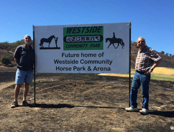
A sign identifying the site of the future home of the horse park in Lakeport, Calif., recently was installed at the location off of Highway 175. At left, Westside Community Park Committee President Dennis Rollins and Walt Christensen with the sign. Courtesy photo. LAKEPORT, Calif. – The Westside Community Park Committee is in the process of developing 10 acres of land in Lakeport into a horse park.
The park will be located off of Highway 175 just outside of the city limits.
The committee reported that this will be a multi-phased project.
The initial phase will develop access from the state highway. VanDerWall Engineering in Kelseyville was contracted by the committee to design the entrance to the horse park from Highway 175.
Drawings have been submitted to the city of Lakeport and will become part of the application to Caltrans for the required encroachment permit.
The committee reported that city staff will handle the application process. When the encroachment permit is issued construction of the access can begin.
The immediate vision once the entrance from the highway is complete is a 150-foot by 300-foot arena and parking. Engineering and design work will be required before that construction can start.
Based upon the needs expressed at past meetings with members of the horse community the long range goal is to add a round pen, smaller exercise arena, sprinklers, facilities for manure removal, restrooms, overnight hookups and other facilities as needed.
Although not located on the site of the Westside Community Park, the horse park will be part of the established park, with development, initial operation and maintenance it be overseen by the Westside Community Park Committee.
The committee also is developing fundraising opportunities.
Development of facilities on undeveloped land is expensive. Engineering, design, earth moving, drainage construction and materials will all cost a substantial amount. The committee said the actual cost cannot be calculated until engineering calculation and design are completed.
If you are interested in helping to support this project, tax-deductible donations can be made to the Westside Community Park Committee, 1350 Berry St., Lakeport, CA 95453.
The Westside Community Park Committee is a registered 501(c)3 nonprofit corporation governed by a volunteer board of directors consisting of seven members.More information can be obtained at the Committee's website; www.westsidecommunitypark.org.
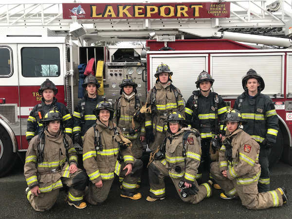
A fire academy for new recruits at the Lakeport Fire Protection District was funded by the Lakeport Volunteer Firefighter's Association, thanks to its annual dinner, dance and auction fundraiser. Courtesy photo. LAKEPORT, Calif. – The Lakeport Volunteer Firefighters Association is preparing for its annual fundraiser and members are asking for the community’s help in gathering donations for the event.
The ninth annual dinner, dance and auction takes place on Saturday, Oct. 20, at the Lake County Fairgrounds, 401 Martin St.
“It’s our only fundraiser for the year,” said association member Pamela Kane.
She said the dinner is made possible with the generous support of the community.
It funds the $5,000 Matt Black Memorial Scholarship for Clear Lake High School students and provides safety training and equipment for the volunteer firefighters, she said.
Kane said that one year they bought $26,000 worth of masks for the firefighters, another year bought a filtration system, last year bought fire hoses and nozzles and also helped fund a fire academy for new recruits.
The dinner already is sold out, with more than 500 guests coming and many people now on a waiting list, Kane said.
However, there are many ways community members can help, including offering donations for the silent and live auctions, and the raffle, she said.
Donations cover a wide variety of items, as well as cash. “You name it, we get it,” Kane said.
“We have really awesome support,” she added.
Kane said the deadline for donations is Friday, Oct. 12.
If you are interested in donating items that that need to be picked up please call the Lakeport Fire Department at 707-263-4396 or you can drop them off Monday through Friday from 8 a.m. to 5 p.m. at the fire station, 445 N. Main St.
For more information, call Kane at 707-631-0938.
Email Elizabeth Larson at This email address is being protected from spambots. You need JavaScript enabled to view it.. Follow her on Twitter, @ERLarson, or Lake County News, @LakeCoNews.
Looking back, it’s an ironic name, given the significant events that took place there on Oct. 7, 1780.
King’s Mountain is a long, narrow ridge with boulder-strewn slopes due west of Charlotte, North Carolina.
At just a little over 1,000 feet tall, it is only a mountain in the eastern sense of the word – we out west might characterize it a hillock if we were feeling especially generous.
At any rate, it was on this aptly named mountain that American patriot forces finally turned the tide in their war against the British crown.
By fall of 1780, things were looking grim for the American cause. Although Washington had won some victories over the British at Trenton, Princeton, and Monmouth Courthouse, the war up until then had been one largely of cat-and-mouse, with the American forces trying to outmaneuver the British.
Many of the American victories up until then was as much a result of the abysmal leadership on the British side as it was the quality of generalship on the American.
But after three years of expensive warfare in a conflict that was supposed to only last a single campaign season, the British public was growing weary.
Aware that continued stalemate in America would be just as bad as outright failure, the British tried a new tactic. Rather than continue an all-out war on the Continental Army in the north, as they had been doing, they would focus their efforts on securing the aid of the loyalists.
Ever since the opening of the war, the British were convinced that the majority of colonials were loyal to the crown. Although they had secured some aid from loyalists in New York, British command believed that the south was positively teeming with them.
So, in 1778, they shipped their men to the south. And the tactic appeared to be working. They occupied Savannah, Georgia, in late 1778 and Charleston, South Carolina, in May 1779. They also struck a disastrous blow against American General Horatio Gates' forces at Camden, South Carolina, in August of 1780.
For all of these victories, however, the war continued to drag on interminably. Although they were succeeding in conventional battles, the American forces under Nathaniel Greene and Daniel Morgan pestered them with guerilla warfare, sapping their resources while always managing to stay just out of reach.
This was the state of things when Major General Charles Cornwallis decided his forces were ready to move against the patriots in North Carolina. Moving with the main force himself, Cornwallis entrusted his left flank to the very competent Major Ferguson, who had succeeded in raising a sizeable force of loyalists.
As the forces proceeded with their plan, Ferguson and his some 1,100 loyalists were able to sweep away the uncoordinated attacks of local militia bands. But as they continued northward, they started to meet more resistance and when word reached him of an army forming to stop him, Major Ferguson sent for reinforcements from Cornwallis and made camp with his army on the slopes of a nearby mountain: King’s Mountain.
It was true; an army of sorts was forming in an attempt to stop the marauding band of loyalists. In the end, however, the patriots were only able to gather some 900 men – all of them militiamen from as far away as Virginia and as close by as the field over the rise. But many of these men were rugged outdoorsmen, as proficient in the use of the rifle as any on the North American continent.
Early in the afternoon of Oct. 7, 1780, the small band of militiamen arrived at the foot of King’s Mountain (possibly named for a local farmer rather than King George III).
Determining to surround Ferguson and prevent any sort of escape, the Americans launched a four-pronged attack, with two columns advancing on both sides of the mountain. Ferguson and his loyalists were apparently taken by surprise by the militiamen’s ferocity of attack.
The battle waged on, with the shrill cry of a whistle sometimes audible over the cacophony of the fight. Major Ferguson carried a silver whistle, which he used to direct the movement of his troops, and the clear trill of it encouraged his embattled men.
But then the whistle went silent.
Realizing that he was surrounded, Major Ferguson had attempted to lead a sortie with some of his men in an attempt to break out of the tightening noose of militiamen. He was shot down, mid-whistle blow, by one of the rugged marksman of the American militia.
In about an hour’s time, Ferguson and 250 of his men had been killed, with another 163 wounded and the rest captured or missing. In a single fight, the American forces had obliterated the left flank of Cornwallis’ advance into North Carolina.
The Battle of King’s Mountain would be the last major battle of the war in which colonial loyalists participated. Although just a single conflict, the battle marked the beginning of the end for the British effort in the south and, ultimately, the war.
Antone Pierucci is curator of history at the Riverside County Park and Open Space District and a freelance writer whose work has been featured in such magazines as Archaeology and Wild West as well as regional California newspapers.
LAKE COUNTY, Calif. – Lake County Animal Care and Control is offering a group of mixed-breed dogs this week.
Dogs available for adoption this week include mixes of German Shepherd, husky, Labrador Retriever, pit bull and Rottweiler.
Dogs that are adopted from Lake County Animal Care and Control are either neutered or spayed, microchipped and, if old enough, given a rabies shot and county license before being released to their new owner. License fees do not apply to residents of the cities of Lakeport or Clearlake.
If you're looking for a new companion, visit the shelter. There are many great pets hoping you'll choose them.
The following dogs at the Lake County Animal Care and Control shelter have been cleared for adoption (additional dogs on the animal control Web site not listed are still “on hold”).
This female pit bull terrier is in kennel No. 8, ID No. 11074. Photo courtesy of Lake County Animal Care and Control. Female pit bull terrier
This female pit bull terrier has a short white and gray coat.
She’s in kennel No. 8, ID No. 11074.
“Hashi” is a male pit bull terrier-shepherd mix in kennel No. 13, ID No. 7499. Photo courtesy of Lake County Animal Care and Control. ‘Hashi’
“Hashi” is a male pit bull terrier-shepherd mix.
He has a short tan coat.
He’s already been neutered.
He’s in kennel No. 13, ID No. 7499.
This female pit bull terrier is in kennel No. 14, ID No. 11152. Photo courtesy of Lake County Animal Care and Control. Female pit bull terrier
This female pitbull terrier has a brindle and white coat.
She’s in kennel No. 14, ID No. 11152.
This male pit bull terrier is in kennel No. 21, ID No. 11193. Photo courtesy of Lake County Animal Care and Control. Male pit bull terrier
This male pit bull terrier has a short black and white coat.
He’s in kennel No. 21, ID No. 11193.
This female pit bull terrier is in kennel No. 22, ID No. 11192. Photo courtesy of Lake County Animal Care and Control. Female pit bull terrier
This female pit bull terrier has a short brown coat.
She’s in kennel No. 22, ID No. 11192.
This male German Shepherd-husky mix is in kennel No. 23, ID No. 11051. Photo courtesy of Lake County Animal Care and Control. German Shepherd-husky mix
This male German Shepherd-husky mix has a short black and tan coat.
He’s in kennel No. 23, ID No. 11051.
This male pit bull terrier is in kennel No. 25, ID No. 11082. Photo courtesy of Lake County Animal Care and Control. Male pit bull terrier
This male pit bull terrier has a short brindle and white coat.
He’s in kennel No. 25, ID No. 11082.
“Naquysa” is a female husky-shepherd mix in kennel No. 27, ID No. 11000. Photo courtesy of Lake County Animal Care and Control. ‘Naquysa’
“Naquysa,” which means “Star,” is a female husky-shepherd mix with a long black and tan coat.
She’s in kennel No. 27, ID No. 11000.
“Winston” is a male pit bull terrier-Rottweiler in kennel No. 34, ID No. 10970. Photo courtesy of Lake County Animal Care and Control. ‘Winston’
“Winston” is a male pit bull terrier and Rottweiler mix with a short black and brown coat.
He was taken in during the Mendocino Complex in the city of Lakeport.
He’s in kennel No. 34, ID No. 10970.
Lake County Animal Care and Control is located at 4949 Helbush in Lakeport, next to the Hill Road Correctional Facility.
Office hours are Monday through Friday, 11 a.m. to 5 p.m., and 11 a.m. to 3 p.m., Saturday. The shelter is open from 11 a.m. to 4 p.m. Monday through Friday and on Saturday from 11 a.m. to 3 p.m.
For more information call Lake County Animal Care and Control at 707-263-0278.
Email Elizabeth Larson at This email address is being protected from spambots. You need JavaScript enabled to view it.. Follow her on Twitter, @ERLarson, or Lake County News, @LakeCoNews.
LAKE COUNTY, Calif. – Today’s home fires burn faster than ever. In a typical home fire, you may have as little as one to two minutes to escape safely from the time the smoke alarm sounds.
Knowing how to use that time takes planning and practice. Although people feel safest in their home, it is also the place people are at greatest risk fire. Overconfidence contributes to a complacency toward home escape planning and practice.
“As we approach Fire Prevention Week, now is the time to take a look around your home and see where your hidden hazards are,” said Chief Dennis Mathisen, California State fire marshal. “That means go room by room, and really look closely at where you have items placed, stored, and plugged in. We all can do a better job of reducing our risks by being more fire aware and creating a potentially life-saving escape plan and then practicing it.”
Smoke alarms are the eyes and ears to alert people to a fire. Smoke alarms can mean the difference between life and death as working smoke alarms cut the risk of dying in a home fire in half. Install smoke alarms in every sleeping room, outside each separate sleeping area, and on every level of the home, including the basement.
Take the time to plan an escape route for everyone in the home, designating a “meeting spot” outside. What good is an escape route, if no one remembers it? The answer is simple: practice, practice, practice and make it fun! The more often you practice (day and night), the more comfortable your children will be in escaping, and less likely to hide.
Heating equipment is one of the leading causes of home fires during the winter months. Space heaters are the type of equipment most often involved in home heating equipment fires. All heaters need space.
Keep anything that can burn at least three feet away from heating equipment. Have a 3-foot “kid-free zone” around open fires and space heaters. Purchase and use only portable space heaters listed by a qualified testing laboratory. Maintain heating equipment and chimneys by having them cleaned on a regular basis.
Remember these three easy things when making your home safe:
– Look for possible fire hazards in your home and eliminate them. Are your outlets overloaded? Check the circuit loads of your electrical appliances and devices and unplug when not in use. Inspect your appliance cords. If any are torn, ripped, or damaged in any way, replace them immediately. If a cord or plug ever feels hot, unplug it. – Listen for the sound of the smoke alarm. Know that you may have only minutes to get out if a fire starts. – Learn two ways out of every room. Exits should be easy to access and free of clutter. After leaving the home, go to your family’s designated meeting spot that was created when you set up your home fire escape plan.
MENDOCINO NATIONAL FOREST, Calif. – Fire restrictions will be lifted on the Mendocino National Forest at 12 a.m. Monday, Oct. 8, forest officials announced.
Beginning Monday, forest visitors may have open campfires and camp stoves outside of designated campgrounds providing they are in possession of a valid California Campfire Permit.
Campfire Permits are free and are available at all Forest Service, BLM, or Cal Fire offices, or online at www.PreventWildfireCA.org.
“The cooler temperatures, longer nights, higher humidity and some precipitation have reduced the threat of extreme fire danger. Enjoy the forest but remember it is everyone’s responsibility to constantly practice fire safety and help prevent wildfires,” said Forest Supervisor Ann Carlson.
Fireworks are never allowed on public lands. Check with local offices for current information before traveling to the forest.
Follow these campfire guidelines:
· Clear all flammable material away from the fire for a minimum of five feet in all directions.
· Make a fire only if you have a shovel and sufficient water to put it out.
· Have a responsible person in attendance at all times.
· Never leave your campfire unattended.
· Never build a campfire on a windy day.
· To make sure your campfire is out, drown with water and stir with dirt, making sure all burned materials are extinguished. Feel with your hand to make sure it’s out cold.
· Every campfire will be put dead out before leaving it.
On Oct. 3, 2018, Parker Solar Probe performed the first significant celestial maneuver of its seven-year mission. As the orbits of the spacecraft and Venus converged toward the same point, Parker Solar Probe slipped in front of the planet, allowing Venus' gravity – relatively small by celestial standards – to twist its path and change its speed.
This maneuver, called a gravity assist, reduced Parker's speed relative to the Sun by 10 percent – amounting to 7,000 miles per hour – drawing the closest point of its orbit, called perihelion, nearer to the star by 4 million miles.
Performed six more times over the course of the seven-year mission, these gravity assists will eventually bring Parker Solar Probe's closest approach to a record 3.83 million miles from the Sun's surface – about a seventh the distance of the current record-holder, Helios 2, which achieved a pass of 27 million miles from the Sun in 1976.
Even before its closest approach, Parker Solar Probe is expected to overtake this record and become the closest human-made object to the Sun in late October 2018.
A long-held dream
A solar probe has been on the minds of scientists and engineers for decades, since the late '50s, when a new theory and the first satellite measurements of the Sun's constant outflow of material, called the solar wind, pointed towards previously unsuspected complexity.
But if you'd asked anyone before 2007 – well after serious planning for such a mission began – Venus would not have come up as the key to the mission puzzle.
For the three-plus decades that various committees and teams worked on different concepts for the solar probe mission, it was widely agreed that the only way to dive into the solar atmosphere required sending the spacecraft to Jupiter first.
"No one believed using Venus gravity assists would be possible, because the gravity assist a planetary body can provide is proportional to the body’s mass, and Venus’ mass is so much smaller – only 0.3 percent of Jupiter’s," said Yanping Guo, mission design and navigation manager for the Parker Solar Probe mission at the Johns Hopkins University Applied Physics Lab in Laurel, Maryland. "You compare the gravity assist Venus can provide to what Jupiter can provide, and you have to do repeated flybys to achieve the same change. Then you're getting a very long mission duration."
Getting close to the Sun is more difficult than one might think. Any spacecraft launched from Earth starts off traveling at our planet's 67,000-mile-per-hour sideways pace, speed that it must counteract before it can get anywhere near the Sun.
Gravity assists are one of the most powerful tools in an orbit designer's toolbox to solve this problem: Instead of using expensive, precious fuel to change direction or speed (or both), gravity assists let you harness the natural pull of a planet, with time as the only cost.
Most deep-space missions that use planetary gravity assists use them to gain speed – like OSIRIS-Rex, which used Earth's gravity to rocket towards asteroid Bennu – or to change direction, like Voyager 2, which performed a gravity assist after its final planetary flyby at Neptune to bank toward its moon, Triton.
The idea for a solar probe gravity assist was a little different. In the original orbit plans, the primary functions of the Jupiter gravity assist were to slow the spacecraft's speed to almost nothing and fling it upwards, out of the nearly-flat plane that contains all of the known planets of the solar system, called the ecliptic plane.
This would put the solar probe on a path to get a rare and better-than-ever look at the Sun's polar regions, which are difficult to image, but important scientifically as they produce some of the Sun's high-speed solar wind. Nearly all of our solar observatories have orbited in the ecliptic plane, with the exception of Ulysses, which used a Jupiter gravity assist to achieve polar passes more than 200 million miles from the Sun.
But sending a spacecraft out to Jupiter and bringing it back into the inner solar system is hard. First, no matter how you plan the journey, it's a long mission, with a minimum of nearly half a decade between meaningful events. Most of the time would be spent cruising in deep space.
Second, traveling that far from the Sun means you have to get creative with power. Near Jupiter, the sunlight is about 25 times dimmer than what we experience at Earth, so the only options are huge solar panels to make the most of the sparse sunlight, or some other source of power, like nuclear.
Large solar panels pose a problem for a solar probe, though, because the panels would need to be shielded during solar encounters to avoid overheating.
The size of a solar panel required to power the spacecraft out near Jupiter is too big to effectively stow near the Sun, so they'd have to be jettisoned at perihelion – and that limits you to just one solar pass, once you've lost your source of power. With nuclear power – a radioisotope thermoelectric generator, or RTG, the same source that powers deep-space missions like Cassini and New Horizons – performing a Jupiter gravity assist is a viable option.
Changing the mission paradigm
But the mission design was soon to change. David McComas, chair of the definition committee, remembers a call from Andy Dantzler, then project manager for the Solar Probe mission at APL. Dantzler passed away in 2011 at age 49; the Delta IV Heavy rocket that carried Parker Solar Probe to space was dedicated to him.
"Andy asked if there was any way the committee might go for a mission where you stay in the ecliptic plane but have lots of passes by the Sun and slowly reduce the perihelion," said McComas, who is now the principal investigator of the mission's Integrated Science Investigation of the Sun, or ISʘIS, suite and a professor of astrophysical sciences at Princeton University in New Jersey.
This was an entirely new paradigm for the mission. A hallmark of the original plan was passing over the Sun's poles, the source of the Sun's fast solar wind but a region of relative mystery to scientists. Additionally, staying in the ecliptic plane would almost certainly mean ending up farther from the Sun than had previously been anticipated.
"If you're trading perihelion distance, you have to swap it for something that will give you opportunities to fill in the science in some other way," said McComas.
Subsequently, two developments supported the choice to make these changes to the orbit and create the Parker Solar Probe mission we know today.
The first was new research published in 2009 by Thomas Zurbuchen – then a scientist at the University of Michigan and now the associate administrator for the Science Mission Directorate at NASA Headquarters in Washington.
This research showed that the solar wind that could be measured from the ecliptic plane was actually from a diverse mix of sources.
It was not only the slower solar wind known to be more common near the Sun's equator, but also the high-speed solar wind that often originates closer to the Sun's poles.
By sampling the solar wind from the ecliptic plane over a period of years, scientists could learn about this fast solar wind in ways they hadn't previously anticipated.
The second development was the shift that made such sampling possible: the design of Parker Solar Probe's current trajectory.
"When starting, I had no clue if I could find a solution," said Guo, the mission trajectory designer. "Everybody thought Jupiter was the only practical way you could get closer to the Sun, within 10 solar radii."
In 2007, she came up with five alternative options that would keep the spacecraft near the ecliptic plane and would not require traveling out to Jupiter.
These trajectory options used some combination of Earth and Venus gravity assists to gradually draw the spacecraft closer to the Sun over the course of a number of years.
One fulfilled all the requirements for the Solar Probe mission – a total mission duration under 10 years, with a final close approach clocking in under 10 solar radii (equivalent to 4.3 million miles). This was chosen as the trajectory of the current mission, now called Parker Solar Probe after Dr. Eugene Parker, including seven Venus gravity assists that spiral the orbit in closer and closer to the Sun over the mission's seven-year lifetime.
The biggest hurdle to overcome for a trajectory with such repeated gravity assists is phasing. Of course, Venus is in constant motion around the Sun, so every time the spacecraft passes the planet and swings around our star, Venus is in a completely different place.
But Guo's design solves that problem, with multiple opportunities for launch. This trajectory design carries the spacecraft through 24 orbits around the Sun.
The seven Venus gravity assists happen at different points in the spacecraft's orbit, to account for the phasing problem – some, like the one on Oct. 3, happen as the spacecraft heads towards the Sun, while the others happen as Parker Solar Probe speeds away from the Sun.
This orbit is decidedly different than the original single-Jupiter-gravity-assist concept. Rather than two passes over the Sun's poles, coming within 1.23 million miles of the surface, this version of the mission provides 24 passes around the Sun near its equator, coming within 3.83 million miles of the Sun's surface.
Though Parker Solar Probe doesn't get as close to the Sun, this version of the trajectory provides the spacecraft with more than 900 hours in this critical inner region of the Sun's corona, within 20 solar radii (about 8.65 million miles). In comparison, earlier designs using Jupiter gravity assists provided less than 100 hours in this region.
"Here was this technical solution that was safer and cheaper and a better scientific mission because of all the samples we’d be getting," said McComas. "The Sun isn't a stable object – it's variable – so this would let us do a better scientific job."
This change to the mission also solved the power problem. Instead of requiring an RTG or unmanageably-large solar panels, Parker Solar Probe is powered by a pair of articulated solar panels that are slowly drawn into the shadow of the heat shield as the spacecraft approaches the Sun. At closest approach, only a small area remains exposed to generate the needed power for the spacecraft, cooled by the mission's first-of-its-kind solar array cooling system.
But though it solved a major problem, rethinking the mission in this way also required a complete rethinking of the spacecraft itself.
"The whole spacecraft design changed dramatically," said Nicola Fox, formerly the mission's project scientist at APL. Fox is now the director of the heliophysics division at NASA Headquarters. "With the earlier trajectory, the heat shield was the spacecraft. It was like a cone, with the pointed end facing the Sun, because when you're doing such a fast polar orbit it's tough to keep a shield oriented correctly."
"We aren't going in as far with the new trajectory, so we could go to a simpler shape for the heat shield, because it's possible to keep the heat shield oriented between the spacecraft and the Sun at all times. The whole thing looks really different."
The mission team credits Andy Dantzler with guiding them through this fundamental change in the mission's design that led to the mission we know today.
"When Andy called and asked if the definition team would go for it, I really didn't know the answer," said McComas. "As our definition team worked through the science, I became convinced that it wasn't just an equivalent mission, but actually a better scientific mission, because we get so much more time close to the Sun and so many more samples at different times."
The first flyby
During the Oct. 3 gravity assist, Parker Solar Probe came within about 1,500 miles of Venus' surface, reaching this closest point at about 4:45 a.m. EDT.
Venus is an interesting case for heliophysicists, who study not only the Sun, but also its effects on planets. Unlike Earth, Venus doesn't have an internal magnetic field – instead, a weak magnetic field is induced over the surface by the constant barrage of solar charged particles flowing over the planet and interacting with its very dense atmosphere.
This first flyby offered a unique opportunity for calibration, as Parker Solar Probe flew through the trailing end of Venus' magnetic field, called the magnetotail. Three of Parker Solar Probe's four instrument suites – SWEAP, ISʘIS and FIELDS – gathered data during the flyby on particles and fields in this region.
Though the data is still making its way back to Earth, the science team hopes to analyze it before they set their sights on Parker Solar Probe's next major celestial encounter: its first close approach to the Sun. Parker Solar Probe's first solar encounter will happen Oct. 31 – Nov. 11, with the closest approach happening on Nov. 5 at a distance of 15 million miles from the Sun. The science data from this encounter will start downlinking to Earth in early December.
Parker Solar Probe is part of NASA’s Living with a Star program to explore aspects of the Sun-Earth system that directly affect life and society. The Living with a Star program is managed by the agency’s Goddard Space Flight Center in Greenbelt, Maryland, for NASA’s Science Mission Directorate in Washington. APL designed, built and operates the spacecraft.
Sarah Frazier works for NASA's Goddard Space Flight Center, Greenbelt, Md.
The final orbit for the Parker Solar Probe mission uses seven Venus gravity assists to rack up more than 900 hours close to the Sun. The original mission concept, using a single Jupiter gravity assist, got the spacecraft closer to the Sun, but gave scientists less than 100 hours in key areas. Credits: NASA's Goddard Space Flight Center/Mary Pat Hrybyk-Keith.

 How to resolve AdBlock issue?