NORTHERN CALIFORNIA – A wildland fire in Yolo County grew dramatically on Saturday and into Sunday morning, tearing through thousands of acres and causing evacuations to remain in place.
The County fire, originally the Guinda fire, is burning along Highway 16 in the community of Guida.
On Saturday night it was reported to be 8,000 acres, with zero containment, Cal Fire said.
That number nearly doubled during the night; just after 4 a.m. Sunday, reports from the scene said it had been mapped at 15,000 acres.
It is endangering 30 structures and has resulted in evacuations in an area west of Highway 16 from County Road 63 to County Road 76 and the Murphy Ranch area.
The fire began shortly after 2 p.m. Saturday, and quickly began burning east into canyons and onto ridges.
Radio reports on Saturday night stated that the fire was being pushed by strengthening winds from the north with gusts of more than 30 miles per hour per hour expected. That wind activity slowed as morning approached.
Other factors that Cal Fire said are involved in fanning the fire are high temperatures and low relative humidity, part of weekend red flag conditions.
Assigned resources on Sunday night included 41 engines, eight water tenders, 11 helicopters, 10 hand crews, 17 dozers and nine air tankers, Cal Fire said.
Cal Fire said the County fire’s cause is under investigation.
Email Elizabeth Larson at This email address is being protected from spambots. You need JavaScript enabled to view it.. Follow her on Twitter, @ERLarson, or Lake County News, @LakeCoNews.
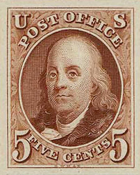
The 1847 Benjamin Franklin stamp. Public domain image.
Well into the 1820s in America, sending a piece of mail or package over to the next town was often the most vexing of all problems – that is, if starting point and destination did not both happen to lie on a stage or post line.
Let’s pretend, for instance, that it’s the fall of 1828 and John Moses, carpenter from South Dewbury, Connecticut, is working on the construction of a new building in the nearby town of Bucksboro, some 40 miles from his home.
A chill has come over the land and Mrs. Moses, fearing her dear Johnny will be caught unprepared for these frigid temperatures, wants to send him his favorite knit scarf. How would she get it to him?
Bucksboro is miles off the stage line that ran through South Dewbury. Sending it by mail would be absurd, between having to travel to the nearest post office some ten miles in Dorchester and then paying more for the postman to go out of his way to get to Bucksboro.
After a morning of worry over the subject, Mrs. Moses wraps the knit scarf in some newspaper and sets out for the two-mile jaunt to the nearest tavern, where the local stagecoach regularly stops.
“Well yes ma’am, I can get it to him,” Thackery Ricketts, the stage-driver, admits reluctantly, as if carrying parcels wasn’t the most lucrative side business of his. “Of course, I can’t take it all the way to Bucksboro, but I can leave it over at the tavern at Burntree Corners, and they can send it over from there.”
“Well that’s a pregnant idea!” cries Mrs. Moses with delight, before a cloud crosses her face. “But how much will that cost?”
Squinting eyes appraise his latest customer. “Well, fifteenpence in advance is the regular fee for that distance,” Thackery says slowly.
“My goodness! That’s an awful lot.”
“Well now, let me see. Don’t go tellin’ nobody, but just for you, I’ll make it a shilling.” Delighted at having found a way to get the scarf to her dearest, Mrs. Moses hands the parcel over and returns home.
“Got anybody going to Bucksboro,” Thackery asks several hours later of the landlord of the “Dueling Arms Tavern” at Burntree Corners.
“Jedidiah heads over tha’ way with his wagon on Fridays,” the landlord says.
“Here, got a package for a fella named John Moses. He’s building a new building up there and his wife wanted him to have his scarf. My charges are paid, but no more,” Thackery informs the man before clambering back aboard his stage.
“Here, package for a John Moses, a wandering carpenter working on a new building in Bucksboro,” the landlord tells Jedidiah three days later, on Friday.
Since his destination is beyond Bucksboro, Jedidiah doesn’t have time to go looking for this John Moses character, so he drops the now well-travelled parcel off at the local tavern.
“Eighteenpence owed on it,” he informs the landlord after telling him who it’s for. The landlord, depending on how good a customer this John is, might add an additional shilling on top of the fee to cover his own “inconvenience.”
And so, assuming the knit scarf didn’t get lost on the way, John Moses would receive his wife’s token of love about a week later, and at a cost that in today’s age of free delivery would send most of us into a long twitter rant.
All of this was at no fault to the United States Postal Office—a venerable institution created by the Second Continental Congress in 1774 and further embellished in later years. In many cases in early America, the postman had to hack his way through overgrown paths and risk exposure to the elements in winter and summer. How would he have time to go out of his way to deliver a scarf to some carpenter in Bucksboro?
Well, over the decades, the network of postal routes expanded, following the growth of steamer lines and locomotives. But it took almost a century for the basic system of payments to change from charging collect to paying a flat fee up front.
A major step in that change was the issuing of the first United States postage stamp. The first of these now all-too familiar square pieces of paper went on sale in New York for the first time on July 1, 1847.
The subject of the first stamp was Benjamin Franklin, the Postmaster General for England in the years leading up to the Revolution (among having a few other notable achievements, I’ve been told).
Imagine how happy the Mrs. Moseses of the country were at this latest innovation. Now THAT was a pregnant idea.
Antone Pierucci is curator of history at the Riverside County Park and Open Space District and a freelance writer whose work has been featured in such magazines as Archaeology and Wild West as well as regional California newspapers.
“Rt. 66 West to East and Back.” This contemporary quilt pieced by Jackie Owens and quilted by Marian Drain came together from a road trip from Lakeport to Florida stopping at fabric stores along the route. Courtesy photo.
LAKEPORT, Calif. – The Ladies of the Lake Quilt Guild invites entries for its 17th annual Falling Leaves Quilt Show.
The show will be held Saturday, Oct. 6, and Sunday, Oct. 7.
The show organizers are calling for quilts from within the community to include in our show.
Entry forms are available now through Aug. 11 on the group’s Web site, or by contacting Barbara Haddon at 415-209-3044 or This email address is being protected from spambots. You need JavaScript enabled to view it..
You don’t need to be a member of the guild to enter your quilts. There is a need for quilts of all sizes as well as vignettes. Vignettes are small items such as baby quilts, doll quilts, table runners, placemats, garments, totes/purses or small wall hangings.
If you would like to enter your quilt, an entry form must be submitted by Aug. 11.
“Violet.” Beginning quilter Catherine Stone learned paper-piecing from a class given by Kathy Sweet. Stone received a ribbon from VIP Judge Lynne Bruner. Quilting was done by Marian Drain. Courtesy photo.
There is no limit on the number of quilts you may enter but each quilt entered must have its own entry form.
Quilters may choose to have their quilts or vignettes judged or to enter quilts and vignettes without judging. Many quilters find it beneficial to have their quilts judged, learning much from an impartial evaluation. The judges are very positive and will award ribbons in several areas.
The Ladies of the Lake Quilt Guild’s 17th annual Falling Leaves Quilt Show is held at the Lake County Fairgrounds in Lakeport on October 6 and 7. The hours on Saturday are 10 a.m. to 5 p.m. and on Sunday from 10 a.m. to 4 p.m.
The guild welcomes all quilters, prospective quilters, and quilt lovers to its meetings and events.
For more information about the quilt guild, contact Terry Phelps at 707-274-1855 or visit the Ladies of the Lake Quilt Guild Web site at www.LLQG.org.
“Red, White & Blue Vintage Sampler.” Lela Prather pieced and quilted this traditional quilt with bright red, white and blues. Courtesy photo.
LAKE COUNTY, Calif. – Lake County Animal Care and Control has five dogs waiting for their new forever homes this week.
Dogs available for adoption this week include mixes of border collie, Labrador Retriever, mastiff, pit bull and shepherd.
Dogs that are adopted from Lake County Animal Care and Control are either neutered or spayed, microchipped and, if old enough, given a rabies shot and county license before being released to their new owner. License fees do not apply to residents of the cities of Lakeport or Clearlake.
If you're looking for a new companion, visit the shelter. There are many great pets hoping you'll choose them.
The following dogs at the Lake County Animal Care and Control shelter have been cleared for adoption (additional dogs on the animal control Web site not listed are still “on hold”).
This young male border collie is in kennel No. 11, ID No. 10334. Photo courtesy of Lake County Animal Care and Control.
Male border collie
This young male border collie has a short black and white coat.
He’s in kennel No. 11, ID No. 10334.
This female shepherd mix is in kennel No. 22, ID No. 10358. Photo courtesy of Lake County Animal Care and Control.
Female shepherd mix
This female shepherd mix has a short brown and black coat.
She’s in kennel No. 22, ID No. 10358.
This male mastiff mix is in kennel No. 26, ID No. 10191. Photo courtesy of Lake County Animal Care and Control.
Male mastiff mix
This male mastiff mix has a short tan and white coat.
He’s in kennel No. 26, ID No. 10191.
This male mastiff mix is in kennel No. 27, ID No. 10192. Photo courtesy of Lake County Animal Care and Control. Male mastiff mix
This male mastiff mix has a short tan and white coat.
He’s in kennel No. 27, ID No. 10192.
This male Labrador Retriever-pit bull mix is in kennel No. 31, ID No. 10082. Photo courtesy of Lake County Animal Care and Control.
Labrador Retriever-pit bull mix
This male Labrador Retriever-pit bull mix has a medium-length brown and black coat.
He already has been neutered.
He’s in kennel No. 31, ID No. 10082.
Lake County Animal Care and Control is located at 4949 Helbush in Lakeport, next to the Hill Road Correctional Facility.
Office hours are Monday through Friday, 11 a.m. to 5 p.m., and 11 a.m. to 3 p.m., Saturday. The shelter is open from 11 a.m. to 4 p.m. Monday through Friday and on Saturday from 11 a.m. to 3 p.m.
For more information call Lake County Animal Care and Control at 707-263-0278.
Email Elizabeth Larson at This email address is being protected from spambots. You need JavaScript enabled to view it.. Follow her on Twitter, @ERLarson, or Lake County News, @LakeCoNews.
Using observations from NASA’s Hubble Space Telescope and ground-based observatories, an international team of scientists have confirmed ′Oumuamua (oh-MOO-ah-MOO-ah), the first known interstellar object to travel through our solar system, got an unexpected boost in speed and shift in trajectory as it passed through the inner solar system last year.
“Our high-precision measurements of ′Oumuamua’s position revealed that there was something affecting its motion other than the gravitational forces of the Sun and planets," said Marco Micheli of ESA’s (European Space Agency) Space Situational Awareness Near-Earth Object Coordination Centre in Frascati, Italy, and lead author of a paper describing the team's findings.
Analyzing the trajectory of the interstellar visitor, co-author Davide Farnocchia of the Center for Near Earth Object Studies (CNEOS) at NASA’s Jet Propulsion Laboratory (JPL) found that the speed boost was consistent with the behavior of a comet.
“This additional subtle force on ′Oumuamua likely is caused by jets of gaseous material expelled from its surface,” said Farnocchia. “This same kind of outgassing affects the motion of many comets in our solar system.”
Comets normally eject large amounts of dust and gas when warmed by the Sun. But according to team scientist Olivier Hainaut of the European Southern Observatory, “there were no visible signs of outgassing from ′Oumuamua, so these forces were not expected.”
The team estimates that ′Oumuamua’s outgassing may have produced a very small amount of dust particles – enough to give the object a little kick in speed, but not enough to be detected.
Karen Meech, an astronomer at the University of Hawaii’s Institute of Astronomy and co-author of the study, speculated that small dust grains, present on the surface of most comets, eroded away during ′Oumuamua's long journey through interstellar space.
"The more we study ′Oumuamua, the more exciting it gets," Meech said. "I'm amazed at how much we have learned from a short, intense observing campaign. I can hardly wait for the next interstellar object!"
′Oumuamua, less than half a mile in length, now is farther away from our Sun than Jupiter and traveling away from the Sun at about 70,000 mph as it heads toward the outskirts of the solar system. In only another four years, it will pass Neptune’s orbit on its way back into interstellar space.
Because ′Oumuamua is the first interstellar object ever observed in our solar system, researchers caution that it’s difficult to draw general conclusions about this newly-discovered class of celestial bodies. However, observations point to the possibility that other star systems regularly eject small comet-like objects and there should be more of them drifting among the stars.
Future ground- and space-based surveys could detect more of these interstellar vagabonds, providing a larger sample for scientists to analyze.
The international team of astronomers used observations from Hubble, the Canada-France-Hawaii Telescope in Hawaii, and the Gemini South Telescope and European Southern Observatory's Very Large Telescope in Chile.
The paper with the team’s findings appeared in the June 27 issue of the journal Nature.
JPL hosts CNEOS for the agency’s Near-Earth Object Observations Program, an element of the Planetary Defense Coordination Office within the agency's Science Mission Directorate. Hubble is a project of international cooperation between NASA and ESA. NASA's Goddard Space Flight Center in Greenbelt, Maryland, manages Hubble. The Space Telescope Science Institute (STScI) in Baltimore conducts Hubble science operations.
This illustration shows ‘Oumuamua racing toward the outskirts of our solar system. As the complex rotation of the object makes it difficult to determine the exact shape, there are many models of what it could look like. Credits: NASA/ESA/STScI
NORTHERN CALIFORNIA — A wildland fire that began in Yolo County on Saturday afternoon has grown rapidly and resulted in evacuations.
The County fire was first reported shortly after 2 p.m. Saturday at the area of County Road 63 and Highway 16 near Guinda in Rumsey Canyon, according to Cal Fire.
The fire has resulted in evacuations for an area west of Highway 16, with an evacuation center set up at Rumsey Grange Hall, officials said.
The County fire is reported to be moving into canyons and over ridges to the west of Highway 16.
A Cal Fire report issued just after 5 p.m. estimated the fire’s size at 1,000 acres.
About an hour later, radio reports from the scene estimated it had grown to almost 4,000 acres and was up against Blue Ridge in the Knoxville area, where spotting was occurring.
The fire is being driven by red flag weather conditions consisting of high temperatures, gusty winds and low humidities, Cal Fire said
Early Saturday evening, Cal Fire said there were 38 fire engines, 10 fire crews, 12 helicopters, seven dozers and eight water tenders, along with tankers and air attack working the incident.
Hotshot teams also were responding and more resources are on the way, Cal Fire said.
The County fire began shortly before a flareup occurred on the Pawnee fire east of Clearlake Oaks in Lake County, as Lake County News has reported.
That flareup resulted in another mandatory evacuation order for the Double Eagle Ranch subdivision as well as an advisory evacuation for residents south of Highway 20 between Morgan Valley Road and Highway 16.
A short time later, Highway 20 between Highway 53 and Highway 16 also was closed due to fire activity, authorities said.
Email Elizabeth Larson at This email address is being protected from spambots. You need JavaScript enabled to view it.. Follow her on Twitter, @ERLarson, or Lake County News, @LakeCoNews.
Stephanie McQueen Schieder submitted this photo of the flare up on the Pawnee fire on Saturday, June 30, 2018, as seen from Highway 20 east of Clearlake Oaks, Calif.
CLEARLAKE OAKS, Calif. – A rapidly moving flareup on the Pawnee fire Saturday afternoon began moving toward Highway 20 and led to a call for evacuations for the Double Eagle Ranch subdivision.
Just before 4:40 p.m. the Lake County Sheriff’s Office ordered a mandatory evacuation for the flareup.
On Saturday afternoon, reports from the scene indicated that an area of slopover – fire that had crossed a control line – in the Pawnee fire area had come alive, with a column of smoke visible from a distance.
The fire grew quickly and shortly before 4 p.m. was estimated to be between 50 and 100 acres in size, according to air attack.
Incident command then ordered evacuation notifications to be made to Double Eagle Ranch, which had just been allowed to repopulate on Thursday following a mandatory evacuation of several days due to the Pawnee fire.
Tankers, air attack, dozers and other resources are being directed to the scene.
At about 4:10 p.m. radio reports indicated there were concerns that the fire was bumping into Highway 20.
Just after 4:15 p.m., air attack indicated that the fire could run for several thousand acres if it isn’t stopped quickly.
Minutes later, it was reported that power was being cut to the Double Eagle Ranch, where evacuations were ordered again.
The sheriff’s office issued the evacuation order a short time later, with an evacuation center to be reopened at Lower Lake High School.
Incident command said the priority was to keep the fire from moving into Double Eagle Ranch.
The head – or most rapidly moving portion – of the fire is near Highway 20 while the heel, where it’s less intense, is in the area of Indian Valley Reservoir.
At around 4:45 p.m., the California Highway Patrol said Highway 20 from Highway 53 to Highway 16 had been closed due to fire activity.
Just after 5:15 p.m., the Lake County Sheriff’s Office issued an advisory evacuation notice for residents south of Highway 20 between Morgan Valley Road and State Highway 16.
“The Pawnee fire may expand beyond containment and continue to move south with current weather conditions,” the agency reported.
At about the same time, a large fire was burning in the Guinda area in neighboring Yolo County.
That incident, the County fire, was reported to be close to 1,000 acres after 4 p.m. Saturday, based on radio reports.
More information will be published as it becomes available.
Email Elizabeth Larson at This email address is being protected from spambots. You need JavaScript enabled to view it.. Follow her on Twitter, @ERLarson, or Lake County News, @LakeCoNews.
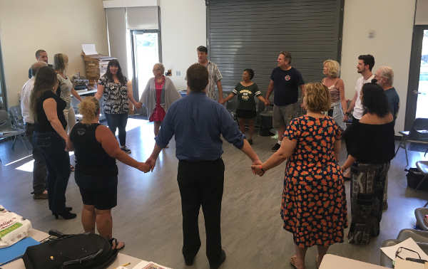
Cast members at a practice for the 2018 Shakespeare at the Lake production of “As You Like It,” in Lakeport, Calif. Courtesy photo.
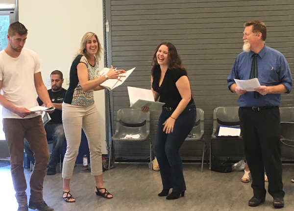
LAKEPORT, Calif. – “Keep the squeeze going,” urged John Tomlinson, director of Shakespeare at the Lake’s upcoming production of “As You Like It,” a joint endeavor by Mendocino College and the Lake County Theatre Co. in cooperation with the Lake County Friends of Mendocino College and the city of Lakeport.
The play's cast is gathered together for rehearsal, starting the evening off with some team building exercises.
In “Pass the Squeeze,” participants join hands in a circle and squeeze the hand of the person on their left as soon as they feel their own right hand get a squeeze.
The game really gets going when a group member starts another squeeze going the opposite direction.
Nervous energy and giggles aplenty, the team building has officially begun.
The cast, many of whom are meeting for the first time, is an eclectic mix of about 20 actors. Some are very green actors with little experience. Others bring decades of training and have performed in dozens of shows. For at least one, As You Like It will be her very first time setting foot on a stage.
Regardless of their theatrical backgrounds, the cast and crew of the play all have a common goal: to bring quality live theater to Lake County. Hopefully they'll also have some fun along the way.
As rehearsal continues, this proves to be true. Tomlinson, Mendocino College theater instructor and founder of the Shakespeare at the Lake project, moves on to blocking the wedding scene, effortlessly moving actors around the space in a way that makes sense to them and to the audience.
Cast members follow direction, all the while getting to know the script, their characters, and each other. It is great fun to watch their friendships, some existing and some brand new, developing in real time.
Heads tossed back in laughter, joking elbows to the ribs, and silly sideways glances all weave their way through a very productive rehearsal. Having positive relationships with fellow cast members is crucial; a cast is a team like no other. Truly, it's more like a family.
In just a few short weeks, these students-turned actors-turned family will take the stage together in Lakeport's Library Park. They will don tie dye and flowing skirts and proudly present As You Like It, set in the 1960s.
Come be part of the extended hippie family on July 28 and 29 at 6:30 p.m.
The show is completely free of charge, made possible through sponsorships and donations. Concessions, including local beer and wine, will be available for purchase, with proceeds benefiting student scholarships.
If you are interested in sponsoring the production and supporting the availability of free live theater in your community, please contact Laura Barnes, Lake County Theatre Co., 707-533-3406, or Wilda Shock, Lake County Friends of Mendocino College, 707-263-7576.
Cast members of the 2018 Shakespeare at the Lake production of “As You Like It,” in Lakeport, Calif., take part in the “Pass the Squeeze” exercise. Courtesy photo.
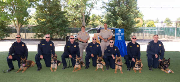
Seven patrol and narcotics detection canine teams graduated on Thursday, June 28, 2018, from the California Highway Patrol CHP Academy in West Sacramento, Calif. Photo courtesy of the California Highway Patrol.
NORTHERN CALIFORNIA – Seven patrol and narcotics detection canine teams graduated on Thursday from the California Highway Patrol CHP Academy in West Sacramento, with one of the teams headed for the CHP’s Northern Division.
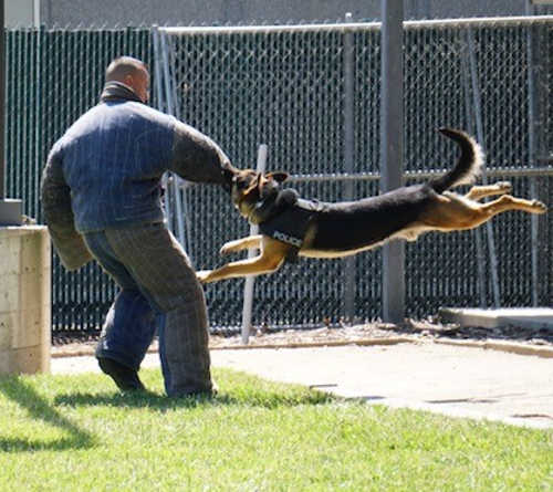
The canines and their handlers completed 13 intensive weeks, or 440 hours, of criminal apprehension and narcotic detection training, according to the CHP.
Participating in the graduation are five Belgian Malinois and two German Shepherds. The CHP said the canines are between the ages of 12 months and 2 years old.
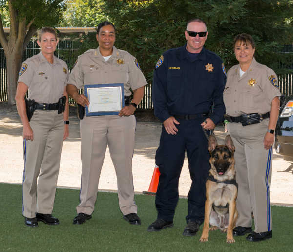
California Highway Patrol Officer Todd Newman and his canine partner, Kastov, will be assigned the CHP’s Northern Division in Northern California. They were among seven patrol and narcotics detection canine teams graduated on Thursday, June 28, 2018, from the California Highway Patrol CHP Academy in West Sacramento. Photo courtesy of the California Highway Patrol. The officers represent the CHP’s Northern, Valley, Golden Gate, Inland, and Border Divisions. All handlers are experienced officers, with between eight and 23 years of experience with the CHP.
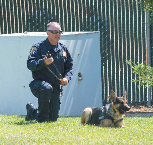
Among the graduates are CHP Officer Todd Newman and his canine partner, Kastov, who will be assigned the CHP’s Northern Division, which covers much of Northern California, including Lake County.
Officer Newman has been with the CHP for 18 years. He has been with the canine program for 10 years, the CHP said.
Kastov is his new partner. His previous K9s were Squad and Cato, according to the CHP.
California Highway Patrol Officer Todd Newman and his canine partner, Kastov. Photo courtesy of the California Highway Patrol.
The CHP said the canines are trained to meet the Commission on Peace Officer Standards and Training canine team guidelines.
The new canine teams must continue to train after they graduate and are required to complete eight hours of training every week, the CHP said.
With this most recent graduation ceremony, the CHP now has 40 patrol and narcotics detection canine teams, five patrol and explosive detection canine teams, and five explosive detection canine teams deployed throughout the state.
California Highway Patrol Officer Todd Newman and his canine partner, Kastov. Photo courtesy of the California Highway Patrol.
LAKE COUNTY, Calif. – A North Coast organization said it is donating to help Lake County recover from the Pawnee fire.
Rebuild Northbay Foundation’s Board of Directors held an emergency meeting on June 25 in response to Pawnee wildfire in Lake County.
The RBNF board approved an immediate donation of $25,000 to Lake County to offset the cost of fighting the Pawnee fire.
“We are aware of the approval of the CalOES/FEMA Fire Management Assistance Grant and while this is tremendously helpful, the grant will cover 75 percent of the county’s cost, therefore leaving the county’s already stressed general fund to cover the remainder. The donation is intended is to provide additional relief to the County of Lake which has withstood multiple fire events since the devastating 2015 Valley Fire,” said Michael Mondavi, executive board of directors and founder of Folio Wine Partners based in Napa Valley.
“Rebuild Northbay Foundation has stepped up on short notice with support for people in need during an active fire. This is very much appreciated from a County trying to serve its citizens after a budget short fall caused by 6 previous emergencies in three years,” said District 3 Supervisor Jim Steele, chair of the Lake County Board of Supervisors.
For those who wish to donate to proven community based organizations in Lake County serving fire victims and evacuees, please visit Rebuild Northbay Foundation’s Website (www.rebuildnorthbay.org) and designate Lake County as the recipient.
All of the funds will go directly to the organizations without incurring administrative fees.
Rebuild Northbay Foundation was born out of the devastating fire disaster of October 2017 and represents Napa, Sonoma, Lake and Mendocino counties.
The foundation is led by business, community, health, education, and environmental leaders brought together to rebuild back better, safer, greener and faster. They are committed to the long-term rebuilding of the region as a more sustainable and resilient community through advocacy, coordination, and economic and workforce development.
Long Term Care Medi-Cal, or LTC Medi-Cal, helps pay for residential skilled nursing care for eligible persons.
Persons who are age 65 or older, disabled (under the Social Security disability rules) or who receive Supplemental Security Income, or SSI, are all categorically linked to LTC Medi-Cal.
LTC Medi-Cal also requires that the applicant and applicant’s spouse, if any, meet asset (needs based) limitations.
The applicant’s own “non exempt assets” cannot exceed the $2,000 Personal Reserve Allowance. For married applicants, the spouse’s own “non exempt assets” cannot exceed the Community Spouse Resource Allowance, i.e., $123,600.00 in 2018.
Exempt assets include one’s residence, one’s personal effects and household furnishing, one vehicle, and a burial plot, burial insurance or a burial fund. Non-Exempt assets count unless they are “unavailable”.
Work related retirement plans owned by the applicant if payments are being deferred are considered to be available – and so count for determining LTC Medi-Cal eligibility. Work related retirement plans includes pensions, individual retirement accounts or IRAs, 401(k) accounts and Keogh accounts.
Work-related retirement accounts belonging to the applicant’s spouse are exempt assets and so do not count as part of the spouse’s CSRA. The applicant’s own retirement accounts, however, are non exempt assets that count unless they are “unavailable”.
If the applicant is aged 70 and a half years old and is receiving the required minimum distributions, or RMDs, required under IRS regulation, then any undistributed portion of the retirement account is unavailable (not counted).
The annual RMDs go to the applicant’s share of cost – i.e., what the applicant pays from the applicant’s own income to the skilled nursing facility.
For example, say John who is 73 years old owns a house, a car, a joint bank account with his wife Jane that has $100,000, and John has an IRA account with a balance of $50,000. Jane can transfer $98,000 from the joint account into a separate account in her name. So long as John is receiving his RMDs each year then John is eligible to receive LTC Medi-Cal as he is above age 65 and both John and Jane meet their resource limitations.
If the applicant is under age 70 and a half years old, however, then he or she must either receive periodic payments, or make systematic withdrawals, from each work related retirement account. Such payments and withdrawals must include both interest and principal from each retirement account.
For example, now say that John is 62 years old but is disabled. John is not yet receiving RMDs. If John requests to receive periodic distributions of principal and interest then the undistributed portion of John’s IRA is unavailable as of when John provides proof that he made the request.
With Roth IRAs, which never require any RMDs, the applicant must either received periodic payments or make systematic withdrawals of principal and interest regardless of the applicant’s age.
Alternatively, a LTC Medi-Cal applicant can request that the retirement plan administrator distribute the entire retirement account in a single lump sum. So long as the applicant makes a bona fide attempt, i.e., takes all necessary steps required to make the withdrawal, then any undistributed retirement assets are treated as unavailable.
The “unavailable” status remains so long as the applicant continues to make good faith bona fide efforts to receive payment and continues to provide verification. Distributions received go towards share of cost.
Although work related retirement plans are not exempt assets they can still become unavailable assets – and not be counted – if the applicant follows certain rules.
The rules discussed above come from the California Department of Health Services’ All County Welfare Directors Letter No. 02-51 (dated Oct. 18, 2002) and from 22 CCR §50458, a DRAFT Regulation itself attached to ACWD Letter 90-01 (dated Jan. 5, 1990).
Dennis A. Fordham, attorney, is a State Bar-Certified Specialist in estate planning, probate and trust law. His office is at 870 S. Main St., Lakeport, Calif. He can be reached at This email address is being protected from spambots. You need JavaScript enabled to view it. and 707-263-3235. His Web site is www.DennisFordhamLaw.com.
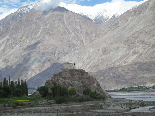
A temple in the Nubra Valley of Ladakh, India, which is in the study area. The picture illustrates the enormous size and scale of the mountains in this part of the Himalayas. Photo by Wendy Bohon.
The Himalayan Range includes some of the youngest and most spectacular mountains on Earth, but the rugged landscape that lends it the striking beauty for which it is known can also keep scientists from fully understanding how these mountains formed.
"We know more about the rocks on parts of Mars than we do about some of the areas in the Himalaya," said Dr. Alka Tripathy-Lang.
"Many researchers have done extraordinary geologic mapping in this rugged region, but the fact is that some places are just completely inaccessible because of topography, elevation, or geopolitical issues. The rocks in those areas are an important piece of the tectonic puzzle and are important for understanding the way the region evolved," said Dr. Wendy Bohon. "The tools we used, originally developed for mapping rocks on Mars, were a way to safely access information about the rocks in the Himalayas."
Bohon and colleagues worked with researchers at the Mars Space Flight Facility at Arizona State University to use data from the Earth orbiting satellite Terra in the same way planetary geologists have been using data from the Mars orbiting satellite Odyssey.
The researchers relied on the fact that every mineral has a unique spectral "signature," where some parts of the thermal infrared spectrum are absorbed and some parts are reflected.
Rocks are made of different combinations of minerals, so when all of these mineral signatures are combined, they reveal the rock type.
To easily distinguish between different kinds of rocks the researchers translated these signals into Red/Green/Blue imagery, which results in a distinguishable color for each rock type that can be used to map the distribution of rocks throughout the region.
To double-check that the colors they're mapping are truly the rock type predicted by the imagery, the researchers took hand samples from accessible locations in the study area to the laboratory and measured the spectral signatures of each rock using a thermal emission spectrometer.
Then they compared these laboratory signatures to those collected from the ASTER (Advanced Spaceborne Thermal Emission and Reflection Radiometer) instrument on the Terra satellite. They matched.
"There is some variation between the lab and ASTER spectral signatures due to different factors like weathering and the averaging area, but overall the match between them was surprisingly consistent," said Tripathy-Lang.
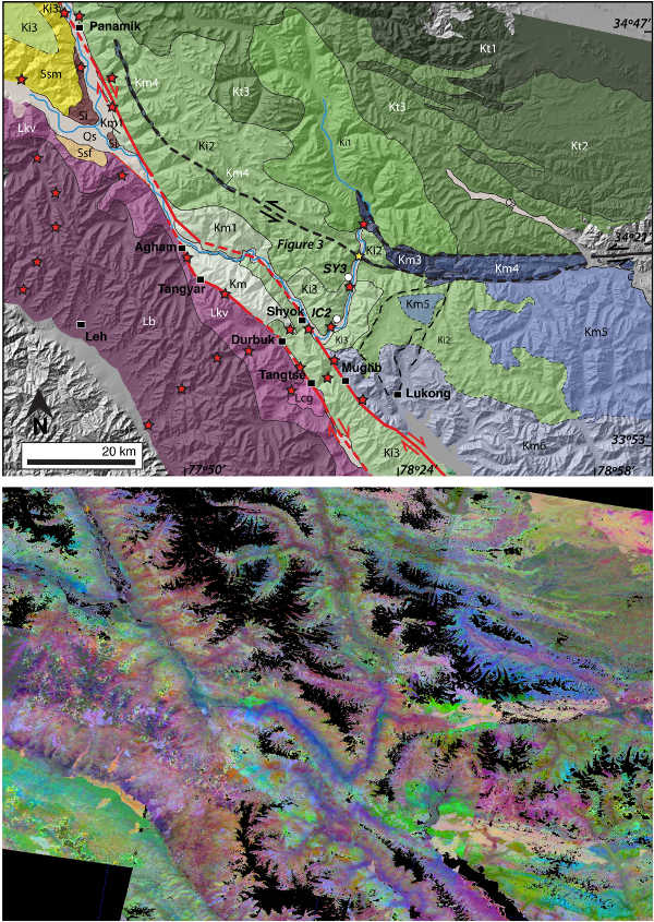
The map they created revealed some interesting geology. They were able to clearly see "suture zones" – ancient seafloor pushed up and exposed during the collision between India and Eurasia – as well as subtle differences in the granitic mountains that indicates different phases of formation.
They were also able the see the intersection of two massive fault systems, the Karakoram and Longmu Co Faults.
"These fault systems are hugely important to the story of the Himalayan-Tibetan collision, and determining the way that these systems have evolved and how they interact is critical for understanding this part of the Himalayan Mountains," said Bohon.
Top: Map made using ASTER satellite data imagery. Bottom: one "stretch" – or one color combination – of the ASTER data that was used to make the map.

 How to resolve AdBlock issue?