 How to resolve AdBlock issue?
News
- Details
- Written by: Nathalie V. Antus
LAKE COUNTY, Calif. – On Saturday special events in Lower Lake and Clearlake celebrated the Christmas season.
The Anderson Marsh Interpretive Association hosted its annual “Old Fashioned Christmas” during the day and Clearlake held its annual “Christmas by the Lake” celebration in the evening.
Anderson Marsh’s open house event started in 1982 and is the nonprofit organization’s way of thanking its supporters and welcoming members of the public to the grounds.
Board member Henry Bornstein helped welcome guests to the ranch house, built in 1855. The structure and fireplaces go back to pre-Civil war days and on special occasions, such as this open house, are filled with live music, singing and a roaring fire.
An active group of volunteers provided beverage refreshments and cookies.
The Christmas tree was decorated this year by Nancy Langdon’s second grade class at Burns Valley School. The tree was to be auctioned in a free raffle at the end of the event.
The ongoing tradition is even more important today, as it brings public awareness to help keep this endangered state park open.
On Saturday evening, it was over to Clearlake for the downtown Christmas celebration.
Sixteen floats decorated in holiday style made their way along Clearlake’s Lakeshore Drive. The parade was a warm holiday treat to a chilly evening in Clearlake.
Santa and Mrs. Claus – escorted by the Clearlake Police Department and Lake County Fire Protection District – led the parade.
Following the parade, the tree lighting ceremony was held at Austin Park.
Winners of the float parade also were announced at the ceremony. They included first place, Nazarene Church; second place, Fancy Paws Pet Grooming; and third place, Performance Mechanical.
A special plaque for community appreciation was presented to the Volunteers in Policing (VIP). Jessie Boyd of Four Corners Builders Supply and the parade organizer, accepted the plaque on the VIPs’ behalf.
Parade goers were entertained throughout the night by dances and songs performed by students from local area schools. Attendees also could get their pictures taken with Santa at the park’s gazebo.
Email Nathalie V. Antus at
- Details
- Written by: Elizabeth Larson
LAKEPORT, Calif. – Four dogs are featured for adoption this week at Lake County Animal Care and Control.
The dogs – mixes of boxer, Chihuahua, American Staffordshire Terrier and German Shepherd – have all been altered and have the necessary shots, so they can go right home with their new owners.
Dogs that are adopted from Lake County Animal Care and Control are either neutered or spayed, microchipped and, if old enough, given a rabies shot and county license before being released to their new owner. License fees do not apply to residents of the cities of Lakeport or Clearlake.
If you're looking for a new companion, visit the shelter. There are many great pets hoping you'll choose them.
The following dogs at the Lake County Animal Care and Control shelter have been cleared for adoption (additional dogs on the animal control Web site not listed are still “on hold”).

Male German Shepherd mix
This male German Shepherd mix is 1 year old.
He has a short black coat, weighs nearly 50 pounds and has been neutered.
He’s in kennel No. 6, ID No. 34894.

‘Mia’
“Mia” is a 2-year-old American Staffordshire Terrier mix.
She has a short red coat, weighs 57 pounds and has been spayed.
Find Mia in kennel No. 7, ID No. 34847.

‘Brody’
“Brody” is an older boxer who recently fell on hard times and arrived at the animal shelter after his owner could no longer keep him.
He is 7 years old, has a docked tail and a short brown brindle-colored coat.
Brody is altered and weighs nearly 90 pounds.
You can find him in kennel No. 10, ID No. 34726.

‘Poncho’
“Poncho” is a 2-year-old male Chihuahua-terrier mix.
He weighs 10.6 pounds and has a medium-length red coat. He has been neutered.
He’s in kennel No. 30, ID No. 34860.
Please note: Dogs listed at the shelter's Web page that are said to be “on hold” are not yet cleared for adoption.
To fill out an adoption application online visit http://www.co.lake.ca.us/Government/Directory/Animal_Care_And_Control/Adopt/Dog___Cat_Adoption_Application.htm .
Lake County Animal Care and Control is located at 4949 Helbush in Lakeport, next to the Hill Road Correctional Facility.
Office hours are Monday through Friday, 8 a.m. to 5 p.m., and 1 p.m. to 3 p.m., Saturday. The shelter is open from 10:30 a.m. to 4:30 p.m. Monday through Friday and on Saturday from 1 p.m. to 3 p.m.
Visit the shelter online at http://www.co.lake.ca.us/Government/Directory/Animal_Care_And_Control.htm .
For more information call Lake County Animal Care and Control at 707-263-0278.
Email Elizabeth Larson at
- Details
- Written by: Lake County News reports
Twin NASA probes orbiting Earth’s moon have generated the highest resolution gravity field map of any celestial body.
The new map, created by the Gravity Recovery and Interior Laboratory (GRAIL) mission, is allowing scientists to learn about the moon’s internal structure and composition in unprecedented detail.
Data from the two washing machine-sized spacecraft also will provide a better understanding of how Earth and other rocky planets in the solar system formed and evolved.
The gravity field map reveals an abundance of features never before seen in detail, such as tectonic structures, volcanic landforms, basin rings, crater central peaks and numerous simple, bowl-shaped craters.
Data also show the moon’s gravity field is unlike that of any terrestrial planet in our solar system.
These are the first scientific results from the prime phase of the mission, and they are published in three papers in the journal Science.
“What this map tells us is that more than any other celestial body we know of, the moon wears its gravity field on its sleeve,” said GRAIL Principal Investigator Maria Zuber of the Massachusetts Institute of Technology in Cambridge. “When we see a notable change in the gravity field, we can sync up this change with surface topography features such as craters, rilles or mountains.”
According to Zuber, the moon’s gravity field preserves the record of impact bombardment that characterized all terrestrial planetary bodies and reveals evidence for fracturing of the interior extending to the deep crust and possibly the mantle. This impact record is preserved, and now precisely measured, on the moon.
The probes revealed the bulk density of the moon’s highland crust is substantially lower than generally assumed. This low-bulk crustal density agrees well with data obtained during the final Apollo lunar missions in the early 1970s, indicating that local samples returned by astronauts are indicative of global processes.
“With our new crustal bulk density determination, we find that the average thickness of the moon’s crust is between 21 and 27 miles (34 and 43 kilometers), which is about 6 to 12 miles (10 to 20 kilometers) thinner than previously thought,” said Mark Wieczorek, GRAIL co-investigator at the Institut de Physique du Globe de Paris. “With this crustal thickness, the bulk composition of the moon is similar to that of Earth. This supports models where the moon is derived from Earth materials that were ejected during a giant impact event early in solar system history.”
The map was created by the spacecraft transmitting radio signals to define precisely the distance between them as they orbit the moon in formation. As they fly over areas of greater and lesser gravity caused by visible features, such as mountains and craters, and masses hidden beneath the lunar surface, the distance between the two spacecraft will change slightly.
“We used gradients of the gravity field in order to highlight smaller and narrower structures than could be seen in previous datasets,” said Jeff Andrews-Hanna, a GRAIL guest scientist with the Colorado School of Mines in Golden. “This data revealed a population of long, linear gravity anomalies, with lengths of hundreds of kilometers, crisscrossing the surface. These linear gravity anomalies indicate the presence of dikes, or long, thin, vertical bodies of solidified magma in the subsurface. The dikes are among the oldest features on the moon, and understanding them will tell us about its early history.”
While results from the primary science mission are just beginning to be released, the collection of gravity science by the lunar twins continues. GRAIL’s extended mission science phase began Aug. 30 and will conclude Dec. 17. As the end of mission nears, the spacecraft will operate at lower orbital altitudes above the moon.
When launched in September 2011, the probes were named GRAIL A and B. They were renamed Ebb and Flow in January by elementary students in Bozeman, Mont., in a nationwide contest. Ebb and Flow were placed in a near-polar, near-circular orbit at an altitude of approximately 34 miles (55 kilometers) on Dec. 31, 2011, and Jan. 1, 2012, respectively.
For more information about the mission, visit www.nasa.gov/grail .
- Details
- Written by: Lake County News reports
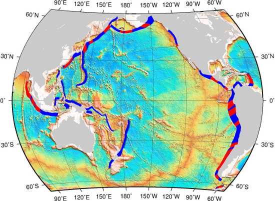
The world’s largest earthquakes occur at subduction zones – locations where a tectonic plate slips under another.
But where along these extended subduction areas are great earthquakes most likely to happen?
Scientists have now found that regions where “scars” on the sea floor, called fracture zones, meet subduction areas are at higher risk of generating powerful earthquakes. The results were published in Solid Earth, an Open Access journal of the European Geosciences Union (EGU).
“We find that 87 percent of the 15 largest (8.6 magnitude or higher) and half of the 50 largest (8.4 magnitude or higher) earthquakes of the past century are associated with intersection regions between oceanic fracture zones and subduction zones,” said Dietmar Müller, researcher at the University of Sydney in Australia and lead author of the Solid Earth paper. The connection is less striking for smaller earthquakes.
Powerful earthquakes related to these intersection regions include the destructive 2011 Tohoku-Oki and 2004 Sumatra events.
“If the association we found were due to a random data distribution, only about 25 percent of great subduction earthquakes should coincide with these special tectonic environments. Therefore, we can rule out that the link we found is just due to chance,” he added.
The floor of the Earth’s oceans is crossed by underwater mountain systems, or ocean ridges, such as the mid-Atlantic ridge that runs from north to south between the Americas and Africa.
These ridges divide two tectonic plates that move apart as lava emerges from the opening, spreading the sea floor.
The mid-ocean ridge jogs back and forth at offsets known as transform faults, creating zig-zagged plate boundaries. Fracture zones are scars in the ocean floor left by these transform faults.
The researchers considered about 1,500 earthquakes in their study. They used a database of significant post-1900 events, as well as geophysical data mapping fracture zones and subduction zones, among others. They analyzed information from these databases by using a specific data mining method.
“The method was originally developed for analyzing online user data,” said Thomas Landgrebe, also involved in the study. “The technique we apply is commonly used to find a few specific items which are expected to be most appealing to an Internet user. Instead, we use it to find which tectonic environment is most suitable for generating great earthquakes.”
Since earthquake generation is a very complex process, the scientists don’t yet have a complete understanding of why great earthquakes prefer the intersection areas.
They suggest that it is due to the physical properties of fracture zones, which result in “strong, persistent coupling in the subduction boundaries,” Landgrebe explained. This means that the subduction fault area is locked and thus capable of accumulating stress over long periods of time.
“The connection we have uncovered provides critical information for seismologists to, in the long run, pinpoint particular tectonic environments that are statistically more prone to strong seismic coupling and great earthquake supercycles,” Müller said.
An area with earthquake supercycles experiences recurring powerful earthquakes every few centuries or millennia.
Regions that have long earthquake supercycles are usually not picked up as risk areas by seismic hazard maps as these are constructed mainly using data collected after 1900.
An example is the area of the 2011 Tohoku-Oki earthquake, which had no record of large earthquakes over the past century and was not predicted to be of significant risk by previous hazard maps.
“The power of our new method is that it does pick up many of these regions and, hence, could contribute to much-needed improvements of long-term seismic hazard maps,” Müller explained. “Even though we don’t fully understand the physics of long earthquake cycles, any improvements that can be made using statistical data analysis should be considered as they can help reduce earthquake damage and loss of life.”