 How to resolve AdBlock issue?
News
- Details
- Written by: Lake County News reports
MENDOCINO NATIONAL FOREST, Calif. – The Mendocino National Forest will be starting a year of visitor surveys this Monday, Oct. 1, at various sites on the forest.
The last survey was completed in 2008, and the surveys are conducted on forests nationally.
Surveys will continue through Sept. 30, 2013.
Forest Service employees and Student Conservation Association employees will be working in developed and dispersed recreation sites and along Forest Service roads.
They will be wearing bright orange vests and near a sign that says “Traffic Survey Ahead.”
The interviewers will be out in all conditions daily for the next year.
Forest visitors are asked to stop and participate in the survey this year, sharing their experiences on the Mendocino National Forest.
Participation is voluntary and all information is confidential – with no names being collected.
Frequent forest visitors are encouraged to participate often. Forest managers are interested in feedback from local people using the forest frequently as well as out-of-area visitors.
The basic interview lasts about eight minutes. Every other visitor will be asked a few additional questions, which may take an additional five minutes.
About a third of all visitors will be asked to complete an additional confidential survey on recreation spending during their trip.
Visitors can expect questions about where they recreated, how many people traveled with them, how long they visited the forest, what recreation sites they visited during their stay, and how satisfied they are with the recreation facilities and services provided.
The information gathered is useful for forest planning, as well as state and local community tourism planning.
It provides National Forest managers with estimates on the number of people recreating on federal lands and the types of activities they are engaging in.
Information on the satisfaction of forest visitors is important in assessing the current and future recreational needs.
Economic information gathered will help in estimating the impact to local communities.
For more information on the Forest Service National Visitor Use Monitoring Program, please visit www.fs.fed.us/recreation/programs/nvum .
For more information locally, please contact the Mendocino National Forest at 530-934-3316, or visit www.fs.usda.gov/mendocino .
- Details
- Written by: Lake County News reports
Gov. Jerry Brown has signed the California State Parks Stewardship Act of 2012, legislation jointly authored by Assemblyman Wesley Chesbro (D-North Coast) designed to make the State Parks system more self-sustaining and stop park closures.
Assemblyman Jared Huffman (D-San Rafael) served as the lead author of AB 1589, while Chesbro and a consortium of assemblymembers from both sides of the aisle served as joint and co-authors.
“It is phenomenal the amount of bipartisan support this bill had,” Chesbro said. “It is major legislation that will change the relationship between the state and State Parks, making State Parks more self-sufficient and well-funded with sustainable revenue sources. It will stop park closures, with a net long-term savings to the state’s general fund.”
AB 1589 calls on the Department of Parks and Recreation to develop a prioritized action plan to increase revenues and collection of unpaid user fees at state parks, while maintaining the character and values of the State Park System.
It also creates a State Park Enterprise Fund and states legislative intent regarding the need for a multi-disciplinary independent assessment of ways to ensure long-term management and sustainable funding options for state parks.
Additionally, it includes provisions that authorize the Department of Motor Vehicles to offer special fee-based state park license plates to support the park system and allow taxpayers to redirect portions of their tax refunds to the California State Parks Protection Fund in exchange for an annual state park day-use access pass.
“AB 1589 gives the state important tools for a future that is increasingly emphasizing the need for more self-generated revenue in our parks,” said California State Parks Foundation President Elizabeth Goldstein.
“While we do not believe that our state park system, a true public good, will ever be able to sustain itself without a core of dedicated, public funding, we do wholeheartedly agree that the movement toward more revenue generation should be done with a roadmap,” said Goldstein. “The action plan required in AB 1589 requires such a roadmap and maintains the need for revenue ideas to be appropriate to the mission and uses of our state parks. We look forward to working with the governor, Legislature and all Californians to implement provisions of AB 1589 and to maintain and strengthen the legacy in our state parks.”
“I’m proud to be joined by my colleagues from both parties in this effort to preserve our state parks,” said Huffman. “This bill gives the state additional tools it needs to help keep state parks open and provide for more sustainable management of parks in the future.”
- Details
- Written by: Dr. Tony Phillips
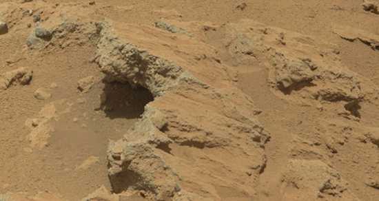
NASA’s Curiosity rover mission has found evidence a stream once ran vigorously across the area on Mars where the rover is driving.
There is earlier evidence for the presence of water on Mars, but this evidence – images of rocks containing ancient streambed gravels – is the first of its kind.
“From the size of gravels it carried, we can interpret the water was moving about 3 feet per second, with a depth somewhere between ankle and hip deep,” said Curiosity science co-investigator William Dietrich of the University of California, Berkeley.
“Plenty of papers have been written about channels on Mars with many different hypotheses about the flows in them,” Dietrich said. “This is the first time we’re actually seeing water-transported gravel on Mars. This is a transition from speculation about the size of streambed material to direct observation of it.”
The finding site lies between the north rim of Gale Crater and the base of Mount Sharp, a mountain inside the crater.
Earlier imaging of the region from Mars orbit allows for additional interpretation of the gravel-bearing conglomerate.
The imagery shows an alluvial fan of material washed down from the rim, streaked by many apparent channels, sitting uphill of the new finds.
The rounded shape of some stones in the conglomerate indicates long-distance transport from above the rim, where a channel named Peace Vallis feeds into the alluvial fan.
The abundance of channels in the fan between the rim and conglomerate suggests flows continued or repeated over a long time, not just once or for a few years.
The discovery comes from examining two outcrops, called “Hottah” and “Link,” with the telephoto capability of Curiosity’s mast camera during the first 40 days after landing.
Those observations followed up on earlier hints from another outcrop, which was exposed by thruster exhaust as Curiosity, the Mars Science Laboratory Project’s rover, touched down.
“Hottah looks like someone jack-hammered up a slab of city sidewalk, but it’s really a tilted block of an ancient streambed,” said Mars Science Laboratory Project Scientist John Grotzinger of the California Institute of Technology in Pasadena.
The gravels in conglomerates at both outcrops range in size from a grain of sand to a golf ball. Some are angular, but many are rounded.
“The shapes tell you they were transported and the sizes tell you they couldn’t be transported by wind. They were transported by water flow,” said Curiosity science co-investigator Rebecca Williams of the Planetary Science Institute in Tucson, Ariz.
The science team may use Curiosity to learn the elemental composition of the material, which holds the conglomerate together, revealing more characteristics of the wet environment that formed these deposits.
The stones in the conglomerate provide a sampling from above the crater rim, so the team may also examine several of them to learn about broader regional geology.
The slope of Mount Sharp in Gale Crater remains the rover’s main destination. Clay and sulfate minerals detected there from orbit can be good preservers of carbon-based organic chemicals that are potential ingredients for life.
“A long-flowing stream can be a habitable environment,” said Grotzinger. “It is not our top choice as an environment for preservation of organics, though. We’re still going to Mount Sharp, but this is insurance that we have already found our first potentially habitable environment.”
For more about Curiosity, visit www.nasa.gov/msl and http://mars.jpl.nasa.gov/msl .
You can follow the mission on Facebook and Twitter at www.facebook.com/marscuriosity and www.twitter.com/marscuriosity .
Dr. Tony Phillips works for the National Aeronautics and Space Administration.
- Details
- Written by: Robert Sanders
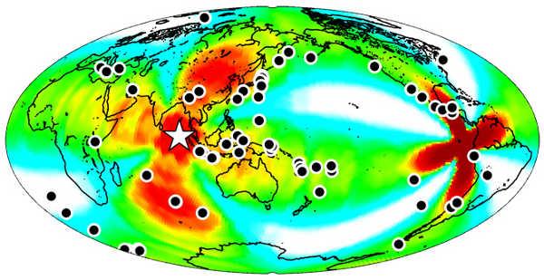
This year’s largest earthquake, a magnitude 8.6 temblor on April 11 centered in the East Indian Ocean off Sumatra, did little damage, but it triggered quakes around the world for at least a week, according to a new analysis by seismologists from the University of California, Berkeley, and the U.S. Geological Survey.
The April 11 quake was unusually large – the tenth largest in the last 100 years and, similar to a few other recent large quakes, triggered small quakes during the three hours it took for seismic waves to travel through Earth’s crust.
The new study shows, however, that some faults weren’t rattled enough by the seismic waves to fail immediately, but were primed to break up to six days later.
The findings are a warning to those living in seismically active regions worldwide that the risk from a large earthquake could persist – even on the opposite side of the globe – for more than a few hours, the experts said.
“Until now, we seismologists have always said, ‘Don’t worry about distant earthquakes triggering local quakes,’” said Roland Burgmann, professor of earth and planetary science at UC Berkeley and coauthor of the study. “This study now says that, while it is very rare – it may only happen every few decades – it is a real possibility if the right kind of earthquake happens.”
“We found a lot of big events around the world, including a 7.0 quake in Baja California and quakes in Indonesia and Japan, that created significant local shaking,” Burgmann added. “If those quakes had been in an urban area, it could potentially have been disastrous.”
Burgmann and Fred F. Pollitz, Ross S. Stein and Volkan Sevilgen of the USGS will report their results online on Sept. 26 in advance of publication in the journal Nature.
Burgmann, Pollitz, a research seismologist, and their colleagues also analyzed earthquake occurrences after five other recent temblors larger than 8.5 – including the deadly 9.2 Sumatra-Andaman quake in 2004 and the 9.0 Tohoku quake that killed thousands in Japan in 2011 – but saw only a very modest increase in global earthquake activity after these quakes.
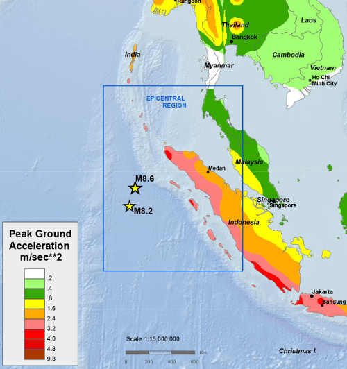
They said this could be because the East Indian Ocean quake was a “strike-slip” quake that more effectively generates waves, called Love waves, that travel just under the surface and are energetic enough to affect distant fault zones.
Burgmann explained that most large quakes take place at subduction zones, where the ocean bottom sinks below another tectonic plate.
This was the origin of the Sumatra-Andaman quake, which produced a record tsunami that took more than 200,000 lives.
The 2012 East Indian Ocean quake involved lateral movement – referred to as strike-slip, the same type of movement that occurs along California’s San Andreas Fault – and was the largest strike-slip quake ever recorded.
“This was one of the weirdest earthquakes we have ever seen,” Burgmann said. “It was like the 1906 San Francisco earthquake, a strike-slip event, but it was huge – 15 times more energetic. This earthquake and an 8.3 that followed were in a very diffuse zone in an oceanic plate close to the Sumatra subduction zone, but it wasn’t a single fault that produced the quake, it was a crisscrossing of three or four faults that all ruptured in sequence to make such a big earthquake, and they ruptured deep.”
The seismologists analysis found five times the expected number of quakes during the six days following the April 11 quake and aftershock.
An unusually low occurrence of quakes during the 6-12 days before that 8.6 quake may have accentuated the impact, possibly because there were many very-close-to-failure faults sensitive to a triggering shock wave, Pollitz said.
One possible mechanism for the delayed action, Burgmann said, is that the East Indian Ocean quake triggered a cascade of smaller, undetectable quakes on these faults that led to larger ruptures later on.
Alternatively, large quakes could trigger nearly undetectable tremors or microquakes that are a sign of slow slip underground.
“One possibility is that the earthquake immediately triggers slow slip in some places, maybe accompanied by detectable tremor, and then that runs away into a bigger earthquake,” Burgmann speculated. “Some slow slip events take days to a week or more to evolve.”
The work was supported by the USGS.
Robert Sanders works for the University of California, Berkeley News Center.