 How to resolve AdBlock issue?
News
- Details
- Written by: Elizabeth Larson
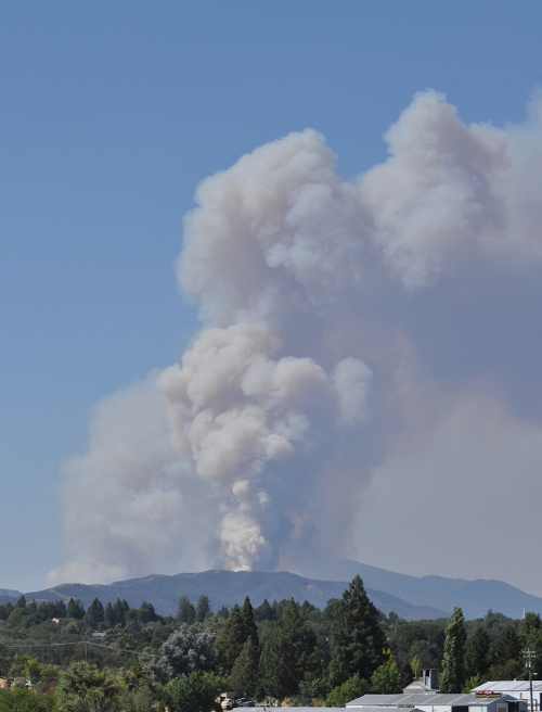
LAKE COUNTY, Calif. – A fire that began early Friday afternoon in the Cow Mountain area had scorched several hundred acres within just a few hours.
The Scotts Fire was reported at about 1:10 p.m. west of Scotts Valley Road on Cow Mountain, east of Ukiah.
The incident initially was believed by Cal Fire to be in Mendocino County. Later in the afternoon, however, Cal Fire said the incident was located in Lake County, which Lakeport Fire Chief Ken Wells, who was monitoring the fire, confirmed.
At about 4 p.m. Wells said the fire was estimated to have burned 450 acres. Within the hour the size was believed to have gone as high as 500 acres, based on reports from the air.
The fire is located in a remote area west of Lakeport, where it was reported to be was running up drainages and ridgetops, and spotting frequently.
Firefighters were accessing the fire up through the Hendricks Ranch, Wells said.
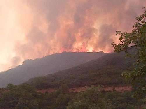
Wells said a local strike team hadn’t been called, with the fire located in the State Responsibility Area covered by Cal Fire.
Radio traffic indicated the US Forest Service also had send firefighters to the incident.
Wells said there were no structures threatened at that point, adding, “They’re making pretty good progress on it.
Air resources worked the fire aggressively throughout the afternoon, with five tankers and a helicopter assigned, and more resources ordered, according to radio reports.
Visibility had been an issue for pilots, and radio reports also indicated that the Ukiah airbase was down to 5,000 gallons of retardant.
The green arrow on the map below shows the coordinates for the head of the Scotts Fire.
Additional details will be posted as they become available.
Email Elizabeth Larson at
- Details
- Written by: Elizabeth Larson
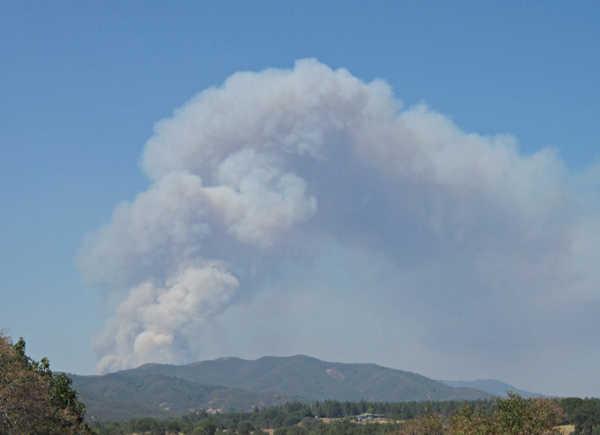
THIS STORY HAS BEEN UPDATED.
NORTH COAST, Calif. – Firefighters from state and federal agencies are responding to a fast-moving new wildland fire in the Cow Mountain area.
Cal Fire and US Forest Service firefighters worked for about a half hour to reach the remote fire – called the “Scotts Incident” – at about 2 p.m. Friday after a “massive column” of smoke was reported near Cow Mountain, which straddles Lake and Mendocino counties.
Shortly before 2:30 p.m. the fire was estimated to be between 175 and 200 acres, and rapidly moving up small drainages, burning up grass and other vegetation, according to reports from the scene.
Firefighters were able to access the fire off Scotts Valley Road and off of Highway 20. At first it was not clear if the fire was on the Lake or Mendocino side of the mountain. Cal Fire later said it was in Mendocino County, but Lakeport Fire Chief Ken Wells said it also was in Lake.
Julie Cooley, a fire prevention specialist with the Cal Fire Mendocino Unit, said initial information indicated that the fire was near the headwaters of Scotts Creek.
Air resources were being diverted from the 16 Complex in Colusa County to go to the new fire, which was going to be difficult to access from the ground, according to radio reports. A call was being made for aircraft and bulldozers.
A total of five tankers and one helicopter were assigned, with one additional helicopter to be assigned, according to reports from the scene.
Visibility is poor due to heavy smoke, making the going difficult for the air resources, radio reports indicated.
Additional details will posted as they become available.
Email Elizabeth Larson at
- Details
- Written by: Elizabeth Larson
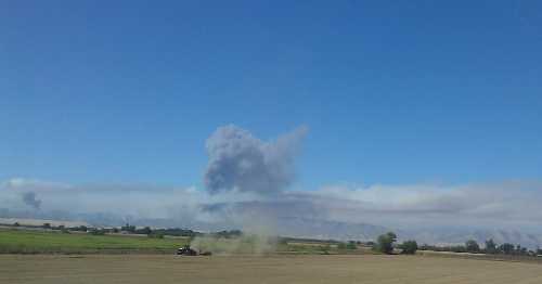
NORTHERN CALIFORNIA – Continued firing operations on two wildland fires in Colusa County resulted in heavy smoke in parts of Lake County on Friday, with more firing operations set to take place to try to slow down the fast-moving fires.
The two-fire 16 Complex grew by about 2,800 acres overnight, with Cal Fire reporting Friday morning that it had burned a total of 12,500 acres, with containment remaining at 20 percent.
The fires, burning since Tuesday, are located four miles apart off of Highway 16 in the Rumsey Canyon area.
Cal Fire estimated the incident will be fully contained on Monday.
Reports of smoke were coming in from around the county on Friday.
Cal Fire said firing operations to get rid of vegetation in the fire’s path had gone on throughout the night, and on Friday shortly before 2 p.m. radio reports indicated more firing operations were about to begin.
On Friday there were 1,268 personnel assigned to the incident, along with 63 engines, 48 fire crews, three airtankers, 10 helicopters, 22 bulldozers and 12 water tenders, Cal Fire said.
So far, three structures have been damaged, with dozens of homes on the Cortina Rancheria threatened. The rancheria remained under an evacuation order on Friday.
Highway 16 from the junction of Highway 20 to the town of Rumsey remained closed.
Email Elizabeth Larson at
- Details
- Written by: Lake County News reports
LAKEPORT, Calif. – Three dead birds and one mosquito sample collected in Lake County tested positive for West Nile Virus this week, local officials reported Friday.
The three West Nile Virus-positive dead birds were American Crows found in Lower Lake, Clearlake Oaks and Lucerne, according to the Lake County Vector Control District.
The positive mosquito sample was collected south of Kelseyville, near Highway 175, the district said.
This year a total of 13 West Nile Virus-positive mosquito samples and five West Nile Virus-positive dead birds have been detected in Lake County, the district reported. No other West Nile Virus activity has been reported in Lake County in 2012.
“We have been fortunate in not having any reports of human West Nile Virus illness in Lake County this year, but we need to remain vigilant and continue to protect ourselves from mosquito bites,” said Lake County Health Officer Dr. Karen Tait.
“West Nile Virus season lasts well beyond Labor Day,” said Jamesina J. Scott, Ph.D., the district manager and research director of the Lake County Vector Control District. “We are still finding infected mosquitoes and dead birds, which means that that people could be exposed.”
Officials encourage residents to protect themselves from mosquito bites by avoiding being outside at dusk and dawn when mosquitoes are most active, and to wear long sleeves and use an insect repellant containing an EPA-registered active ingredient like DEET, Picaridin, oil of lemon eucalyptus or IR353.
Residents are advised to dump out buckets, wading pools and other sources of standing water where mosquitoes can develop in their yards.
The Lake County Vector Control District provides free mosquito-eating fish to Lake County residents for use in animal water troughs, ornamental ponds, and out-of-service (“green”) swimming pools.
The Vector Control District traps and tests mosquitoes throughout the county to identify the areas that have the highest risk, and targets those areas for source reduction and treatment using an integrated vector management program.
Residents are encouraged to call the district for mosquito problems, to get mosquito fish, or to report neglected (“green”) pools and other mosquito sources at 707-263-4770 or to fill out a service request online at www.lcvcd.org .
For more information about West Nile virus, visit http://www.westnile.ca.gov/ .