 How to resolve AdBlock issue?
News
- Details
- Written by: NATIONAL AERONAUTICS AND SPACE ADMINISTRATION

The heat probe hasn’t been able to gain the friction it needs to dig, but the mission has been granted an extension to carry on with its other science.
The heat probe developed and built by the German Aerospace Center and deployed on Mars by NASA’s InSight lander has ended its portion of the mission.
Since Feb. 28, 2019, the probe, called the “mole,” has been attempting to burrow into the Martian surface to take the planet’s internal temperature, providing details about the interior heat engine that drives the Mars’ evolution and geology.
But the soil’s unexpected tendency to clump deprived the spike-like mole of the friction it needs to hammer itself to a sufficient depth.
After getting the top of the mole about 2 or 3 centimeters under the surface, the team tried one last time to use a scoop on InSight’s robotic arm to scrape soil onto the probe and tamp it down to provide added friction. After the probe conducted 500 additional hammer strokes on Saturday, Jan. 9, with no progress, the team called an end to their efforts.
Part of an instrument called the Heat Flow and Physical Properties Package (HP3), the mole is a 16-inch-long (40-centimeter-long) pile driver connected to the lander by a tether with embedded temperature sensors. These sensors are designed to measure heat flowing from the planet once the mole has dug at least 10 feet (3 meters) deep.
“We’ve given it everything we’ve got, but Mars and our heroic mole remain incompatible,” said HP3’s principal investigator, Tilman Spohn of (DLR). “Fortunately, we’ve learned a lot that will benefit future missions that attempt to dig into the subsurface.”
While NASA’s Phoenix lander scraped the top layer of the Martian surface, no mission before InSight has tried to burrow into the soil. Doing so is important for a variety of reasons: Future astronauts may need to dig through soil to access water ice, while scientists want to study the subsurface’s potential to support microbial life.
“We are so proud of our team who worked hard to get InSight’s mole deeper into the planet. It was amazing to see them troubleshoot from millions of miles away,” said Thomas Zurbuchen, associate administrator for science at the agency’s headquarters in Washington. “This is why we take risks at NASA – we have to push the limits of technology to learn what works and what doesn’t. In that sense, we’ve been successful: We’ve learned a lot that will benefit future missions to Mars and elsewhere, and we thank our German partners from DLR for providing this instrument and for their collaboration.”
Hard-earned wisdom
The unexpected properties of the soil near the surface next to InSight will be puzzled over by scientists for years to come. The mole’s design was based on soil seen by previous Mars missions – soil that proved very different from what the mole encountered. For two years, the team worked to adapt the unique and innovative instrument to these new circumstances.
“The mole is a device with no heritage. What we attempted to do – to dig so deep with a device so small – is unprecedented,” said Troy Hudson, a scientist and engineer at NASA’s Jet Propulsion Laboratory in Southern California who has led efforts to get the mole deeper into the Martian crust. “Having had the opportunity to take this all the way to the end is the greatest reward.”
Besides learning about the soil at this location, engineers have gained invaluable experience operating the robotic arm. In fact, they used the arm and scoop in ways they never intended to at the outset of the mission, including pressing against and down on the mole. Planning the moves and getting them just right with the commands they were sending up to InSight pushed the team to grow.
They’ll put their hard-earned wisdom to use in the future. The mission intends to employ the robotic arm in burying the tether that conveys data and power between the lander and InSight’s seismometer, which has recorded more than 480 marsquakes. Burying it will help reduce temperature changes that have created cracking and popping sounds in seismic data.
There’s much more science to come from InSight, short for Interior Exploration using Seismic Investigations, Geodesy, and Heat Transport. NASA recently extended the mission for two more years, to Dec. 2022.
Along with hunting for quakes, the lander hosts a radio experiment that is collecting data to reveal whether the planet’s core is liquid or solid. And InSight’s weather sensors are capable of providing some of the most detailed meteorological data ever collected on Mars.
Together with weather instruments aboard NASA's Curiosity rover and its new Perseverance rover, which lands on Feb. 18, the three spacecraft will create the first meteorological network on another planet.
More about the mission
JPL manages InSight for NASA’s Science Mission Directorate. InSight is part of NASA’s Discovery Program, managed by the agency’s Marshall Space Flight Center in Huntsville, Alabama. Lockheed Martin Space in Denver built the InSight spacecraft, including its cruise stage and lander, and supports spacecraft operations for the mission.
A number of European partners, including France’s Centre National d’Études Spatiales, or CNES, and the German Aerospace Center, are supporting the InSight mission. CNES provided the Seismic Experiment for Interior Structure, or SEIS, instrument to NASA, with the principal investigator at the Institut de Physique du Globe de Paris, or IPGP.
Significant contributions for SEIS came from IPGP; the Max Planck Institute for Solar System Research in Germany; the Swiss Federal Institute of Technology in Switzerland; Imperial College London and Oxford University in the United Kingdom; and JPL.
DLR provided the Heat Flow and Physical Properties Package instrument, with significant contributions from the Space Research Center of the Polish Academy of Sciences and Astronika in Poland. Spain’s Centro de Astrobiología supplied the temperature and wind sensors.
- Details
- Written by: Elizabeth Larson
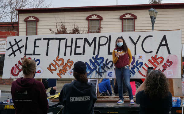
LAKEPORT, Calif. – A large group of parents, students, coaches and other community members gathered in Lakeport Friday afternoon to rally for reopening school sports.
The “Let Them Play” rally, held at Courthouse Museum Park in downtown Lakeport, was one of dozens coordinated to take place across the state on Friday.
For nine months, school sports have been shut down due to COVID-19, and the rallies were meant to bring attention to what supporters say is the need for young people to be able to have sports available to them once again.
Most of Lake County’s schools remain closed to in-person learning due to being in the highest tier, purple, on the state’s Blueprint for a Safer Economy.
Under guidelines issued by the state and the California Interscholastic Federation, the only sport offered at local schools at this time of year that would be allowed is cross country.
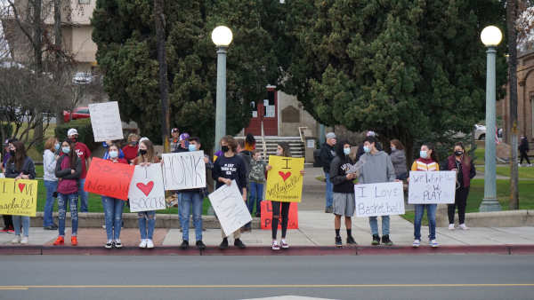
A big crowd was on hand Friday afternoon, lining Main Street between Second and Third Streets.
Lake County News counted close to 120 people in the rally area, and Gerard Fowler, one of the event organizers, estimated there were more than 150 participants at the event’s peak.
“For such a short planning time frame I was pleasantly pleased with the turnout,” Fowler said.
Students and their supporters carried signs with messages including “Let us play,” “I love wrestling,” “Put me in, Coach,” “I love volleyball,” “I love softball” and “Science supports sports.”
A flatbed trailer was parked on the street as a stage, and passing motorists honked in support.
Madeline Young, a sophomore and honor roll student at Upper Lake High School, thanked people for coming.
Young said not having school sports is hurting students.
“Let us play,” she said.
Fowler said those participating came from areas including Kelseyville, Lakeport, Lower Lake, Middletown, Ukiah, Upper Lake and Willits, with all local school districts represented.
It was a peaceful rally with no political agendas, he said.
“It was nice to stand united for our children,” Fowler said.
Email Elizabeth Larson at
- Details
- Written by: Elizabeth Larson
In Washington, DC, heightened security already is in place following last week’s attack on the U.S. Capitol Building.
In an interview with Lake County News on Thursday, Congressman Mike Thompson described how the U.S. Capitol Building is now surrounded by an 8-foot-tall fence topped with razor wire, with the National Mall closed.
“It’s a pretty heartbreaking situation,” Thompson said.
Earlier this week, the California Highway Patrol, the Governor’s Office of Emergency Services and the California National Guard said they want to assure Californians that their collective agencies are working together and remain vigilant to respond to potential threats that may occur anywhere in the state, including the State Capitol.
“Collectively, we maintain strong relationships with our security and intelligence partners at the local, state and federal levels and are continually monitoring and sharing information about possible emerging threats to the state,” the agencies reported in a joint statement.
“Together, our role is to safeguard lives and property and ensure that California remains a safe place for those who live, work, and travel within the state while ensuring the ability of individuals and groups to lawfully exercise their First Amendment rights,” the statement added.
Gov. Gavin Newsom followed up by announcing a series of actions to bolster security in advance of the presidential inauguration.
“In light of events in our nation’s capital last week, California is taking important steps to protect public safety at the State Capitol, and across the state,” said Newsom. “Our State Operations Center is actively working with federal, state and local law enforcement partners in assessing threats and sharing intelligence and information to ensure those disgraceful actions are not repeated here.”
Newsom on Thursday signed a general order authorizing the deployment of 1,000 California National Guard personnel to protect critical infrastructure, including the State Capitol.
To prepare for and respond to any credible threats, the State Operations Center will coordinate 24-hour operations and requests for mutual aid for the coming days, Newsom’s office said. The Law Enforcement Coordination Center will be activated to its highest level to orchestrate overall law enforcement and physical security needs.
Officials said the CHP and Department of General Services have installed a 6-foot chain link fence around the perimeter of the State Capitol to ensure the safety of the Capitol grounds.
Newsom’s office said the administration, through the Governor’s Office of Emergency Services, California Highway Patrol and California National Guard, maintains strong relationships with security and intelligence partners around the country and is continually monitoring for possible emerging threats to the state.
“We are prepared to address any potential threats that may arise. The Administration is also preparing to provide additional law enforcement resources through the Mutual Aid System as needed,” Newsom’s office said.
The governor and his team are also coordinating closely with local, state and federal law enforcement as well as the private sector – including social media companies – to make sure that their platforms are not used by hate groups or domestic terrorists to organize or spread misinformation, disinformation or propaganda.
On Friday, the state took another step to heighten security, with CHP Commissioner Amanda Ray announcing the CHP would go on tactical alert ahead of the presidential inauguration.
Ray said the CHP is prepared to respond to any potential threats which may arise statewide. “The protection of California highways and state buildings, including the Capitol, are the primary responsibility and jurisdiction of the CHP.”
She added, “Due to the potential for civil unrest related to the 2021 Presidential Inauguration, I have placed uniformed CHP personnel on tactical alert for an indefinite period. This allows for the maximization of resources to protect public safety as well as state buildings and infrastructure. The CHP will continue to monitor the situation and plan our resources accordingly.”
Email Elizabeth Larson at
- Details
- Written by: Lake County News reports
That network has helped reduce the size of each public safety power shutoff, or PSPS, event in 2020 on average by 55 percent, or more than 800,000 customers, PG&E spokesperson Deanna Contreras told Lake County News.
Last year, far fewer Lake County residents were involved in PSPS events when compared to late 2019; at one point during that time, the entire county was out for nearly a week.
In 2020, PG&E installed 400 new weather stations and 216 HD cameras as part of its Community Wildfire Safety Program.
These high-tech tools provide better situational awareness and more precise weather monitoring and forecasting that allow for more precision in determining where a PSPS is needed, the company reported.
As of the end of 2020, PG&E had 1,000 weather stations and 340 cameras in operation throughout Northern and Central California, providing more precise weather data to the company’s team of meteorologists and outside agencies, the company reported.
Contreras said more than 30 of those weather stations and seven cameras are in Lake County.
“We did expand our network in 2020 with several additions in Lake County,” Contreras said.
She said 12 weather stations were installed in 2020 in Lake County, with the last one being placed in October.
The stations allow PG&E to more accurately pinpoint conditions with microlocal forecasting. Contreras said they are able to use the data right away and eliminate an area from PSPS scope.
“As a real-time situational awareness tool, we’re able to use our high-density weather observation network at the start of a PSPS event to assess if forecasted critical fire weather conditions are materializing or not,” explainedAshley Helmetag, PG&E senior meteorologist. “In a PSPS event, if the conditions are not materializing above risk thresholds, then we’re able to use this data as a one of our decision-making support tools to significantly shrink or eliminate an area that was originally in scope for power shut off.”
In addition to PG&E’s in-house meteorology team, the expert staff in the company’s Wildfire Safety Operations Center rely on this real-time information, as well as outside agencies and first-responders as they make critical decisions during wildfire season.
PG&E has been adding to its network of weather stations and cameras since 2018, mostly in high fire-threat areas in Northern and Central California.
The program, which plans to install 1,300 weather stations by the end of 2021, is designed to create a density of roughly one weather station for every 20 miles of electric lines in high fire-threat areas.
By the end of 2022, PG&E plans to have nearly 600 cameras installed. When complete, PG&E expects to have the ability to see in real-time roughly 90 percent of the high fire-risk areas it serves.
The stations provide temperature, wind speed and humidity data that is monitored, tracked and evaluated by PG&E’s meteorology team and analysts in the WSOC.
The WSOC is the hub from which PG&E detects, evaluates and monitors wildfire threats across its service area. It’s also where the company instigates responses to those threats and a center for coordination with first responders and public safety officials.
Weather station observations are available to state and local agencies as well as the public, through PG&E’s website at www.pge.com/weather and through MesoWest.
The WSOC staff also use PG&E’s network of fire-watch cameras to monitor and respond to wildfires. These resources are also available to Cal Fire and other fire agencies, as needed.
You can see the data from the weather stations on www.pge.com/weather and the live pictures from the cameras through the Alert Wildfire Network at http://www.alertwildfire.org/northbay/index.html?v=7a7f1bd.