 How to resolve AdBlock issue?
News
- Details
- Written by: Lake County News reports
PG&E said the public safety power shutoff, or PSPS, event will affect customers in portions of 22 counties and seven tribal communities in the northern Sierra foothills, northern Sacramento Valley and elevated North Bay terrain.
This PSPS event is based on forecasts of widespread, severely dry conditions and strong, gusty winds that create critical fire weather with high ignition risk. These conditions are expected to continue through early Wednesday morning.
The power shutoff is expected to impact approximately 172,000 customers in Alpine, Amador, Butte, Calaveras, El Dorado, Humboldt, Kern, Lake, Lassen, Mariposa, Napa, Nevada, Placer, Plumas, Shasta, Sierra, Siskiyou, Sonoma, Tehama, Trinity, Tuolumne and Yuba counties.
The shutoffs began at different times across the PSPS area, with the earliest shutoffs taking place starting at 9 p.m., PG&E said.
In Lake County, 24 residents in the unincorporated areas of the county, none of them medical baseline customers, can expect to have their power shut off between 3 and 6 a.m. Tuesday. PG&E said the estimated time of restoration for those customers is 7 p.m. Wednesday.
PG&E said it will use temporary generation and islanding to enable about 69,000 customers and several medical facilities to stay energized.
The company said it is working to improve the PSPS program by making events smaller in size, shorter in length and smarter for our customers.
Although the National Weather Service has placed 1.5 million customers across PG&E’s service territory under red flag warning conditions, the company has been able to limit public safety PSPS de-energization to less than 12 percent of those customers now under red flag warning risk.
Customers can use an address lookup tool to find out if their location is being monitored for the potential safety shutoff at www.pge.com/pspsupdates.
- Details
- Written by: Elizabeth Larson
LAKE COUNTY, Calif. – The Lake County Sheriff’s Office has expanded a mandatory evacuation order for Pillsbury Ranch to include the entire Lake Pillsbury basin due to fire conditions on the growing August Complex.
The sheriff’s office issued the expanded mandatory evacuation order shortly before 5:30 p.m. Monday, about two hours after ordering residents of Pillsbury Ranch to leave the area.
The upgraded order now includes all areas and residents north of Pack Saddle Creek, south of the Lake County line, west of the Lake County Line and east of the Lake County Line.
Residents are advised that there is an immediate threat to life and property from a wildfire, and are urged to evacuate.
Evacuees needing shelter are directed to a temporary evacuation point that is being established at the Upper Lake County Park, 575 East Highway 20.
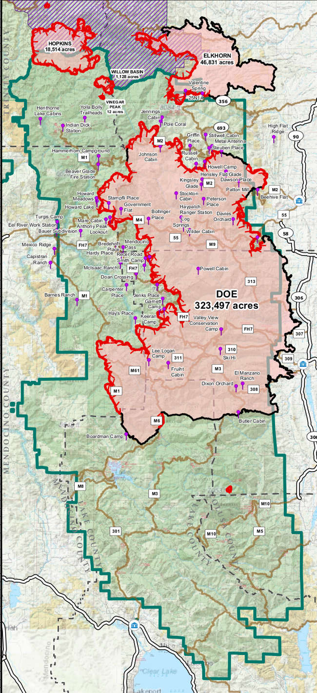
The US Forest Service said the August Complex on the Mendocino National Forest is up to 349,565 acres and 24-percent containment.
A major wind event is forecast for Monday night through early Tuesday morning, which officials said is increasing fire danger.
At the same time, a red flag warning is going into effect on Monday night because of fire weather conditions.
Email Elizabeth Larson at
- Details
- Written by: Lake County News reports
LAKE COUNTY, Calif. – The Lake County Sheriff’s Office on Monday afternoon issued a mandatory evacuation order for the Pillsbury Ranch area due to the growing August Complex and a wind event forecast for the area.
The US Forest Service said Monday the August Complex has grown to 349,565 acres – an increase of 24,000 acres since Sunday – with containment remaining at 24 percent.
Officials said there are 1,138 resources committed to the complex, which is burning primarily in the Mendocino National Forest.
A previous evacuation warning for Pillsbury Ranch had been lifted on Sept. 3, but on Monday shortly before 2:30 p.m. the sheriff’s office instituted a new one due to an expected wind event that begins on Monday evening.
Just over an hour later, the sheriff’s office upgraded that new evacuation warning to a mandatory evacuation order, which covers the areas north of Forest Road M1, south of the Lake County line, west of Bloody Rock and east of the Lake County Line.
Residents and visitors in the area are ordered to leave immediately.
Those in need of shelter should respond to a temporary evacuation point that is being established at the Upper Lake County Park, 575 East Highway 20. Evacuees are asked to stay in their vehicles and wear masks when they arrive at the park. A shelter is being established for them.
The Forest Service said there are multiple wind direction shifts expected through the day and into early morning Tuesday with strong gusts of up to 30 to 40 miles per hour. Winds are expected to shift from the southwest to the northeast by early Tuesday morning.
The National Weather Service issued a red flag warning on Sunday afternoon that’s in effect from 10 p.m. Monday to 8 a.m. Wednesday. There is potential for increased fire activity and spread with heavy smoke production, the Forest Service said.
Officials said fire activity increased Sunday due to high temperatures and gusty winds throughout the complex. Fire crews are prepared for heightened fire activity over the next couple of days due to the extreme forecast weather.
There were successful burnout operations in multiple areas of the complex. The burnout operations along the M2 Road and in the area around the Mitchell Place on the north end of the complex are holding in place, officials said.
Another effective burnout operation from the area around the Mare Cabin down to Brewer Oak Camp progressed steadily ahead of the fire. The Forest Service said the spot fire east of Howard Lake has moved into an old burn scar and is holding on the northern side of the lake.
Firefighters worked to contain the spot fire from Saturday on the Hopkins fire, which is 18,514 acres and 10 percent contained. The Forest Service said those efforts will continue into Monday to hold the containment line. Access to this area from Highway 36 or Forest Road 30 is not advised.
On the southwest corner of the complex, the Forest Service said firefighters will work on the spot fire in the Mendenhall Creek area Monday. This is a focal area for operations ahead of the upcoming northeast winds.
- Details
- Written by: Stephen McCord
NORTHERN CALIFORNIA – Mercury, which occurs naturally in many parts of California’s Coast Range, was mined during three eras in our region: the Gold Rush for recovering gold flakes (late 1800s), the two world wars for munitions (early- to mid-1900s), and most recently for products such as hearing aids, batteries and fluorescent light bulbs (up to the early 1970s).
We are now left with the legacy of about 80 abandoned mercury mines in the upper Cache Creek and Putah Creek watersheds.
This mining largely pre-dated two important developments: major water projects damming and diverting runoff from the two watersheds, and modern environmental laws. Enterprising miners simply dumped their contaminated waste downhill to be swept away in the next storm. That contaminated material still blankets our landscape.
Today’s mercury problem
Mercury is an odd element: it is liquid at room temperature, yet 13 times denser than water. In nature, mercury is a concern because one form, methylmercury, is extremely toxic to humans and wildlife – one droplet is enough to pollute several Olympic-size swimming pools worth of water.
Today, mercury is a common cause of contaminated waters statewide, including in our local watersheds.
Exposure to methylmercury comes largely from eating fish that have accumulated it through their diets to levels about one million times more concentrated than their water.
The state’s Office of Environmental Health Hazard Assessment has issued several warnings for people to limit their consumption of local fish.
But wait … there’s more! The LNU Lightning Complex Fires are burning around many mine sites. Fire impacts on mercury can vary depending on factors such as the fire’s temperature and the forms of mercury, but much more than usual can be released into the air (vaporized and adsorbed to smoke and ash) and downstream (adsorbed to eroded ash and soil).
A silver lining of fires is that they clear the vegetation, making it easier to identify, access and clean up mine sites.
Tuleyome to the rescue
Tuleyome, a nonprofit organization based in Woodland, is a regional leader in cleaning up abandoned mercury mine sites.
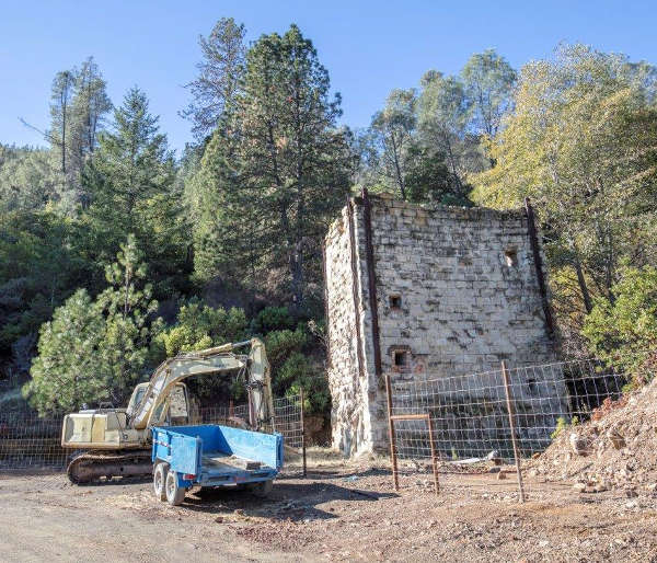
Tuleyome led projects from 2012 to 2019 funded by the California Department of Fish and Wildlife's Ecosystem Restoration Program to clean up the Corona and Twin Peaks mercury mines in northwest Napa County. The site is in the Lake Berryessa watershed, and contributed to high mercury concentrations in fish and fish-eating birds in the streams and lake.
The core project team assembled under Tuleyome’s leadership included many regional experts: soil scientist Vic Claassen from UC Davis, mining geologist Greg Reller of Burleson Consulting in Folsom, general contractor Justin Smith from Middletown, attorney Michael Lozeau of Lozeau & Drury in Alameda, environmental engineer Peter Green from UC Davis, and chemist Tim Tsukamoto of TKT Consulting in Reno, Nevada.
As a “Good Samaritan,” Tuleyome worked with regulators to address the many environmental laws governing abandoned mine sites. The project team spent many hours studying the site’s cultural history, plants and animals.
Those efforts allowed the team to most effectively make the site safer, revegetate barren hillsides, and treat acidic drainage water. Researchers continue to study the bacteria found in the mine drainage water for their ability to thrive in such harsh conditions.
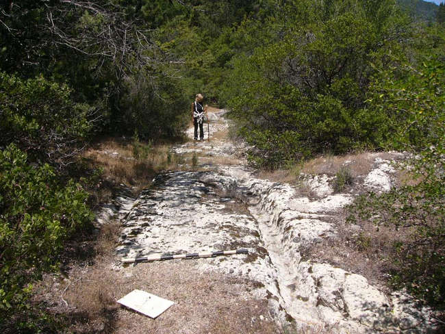
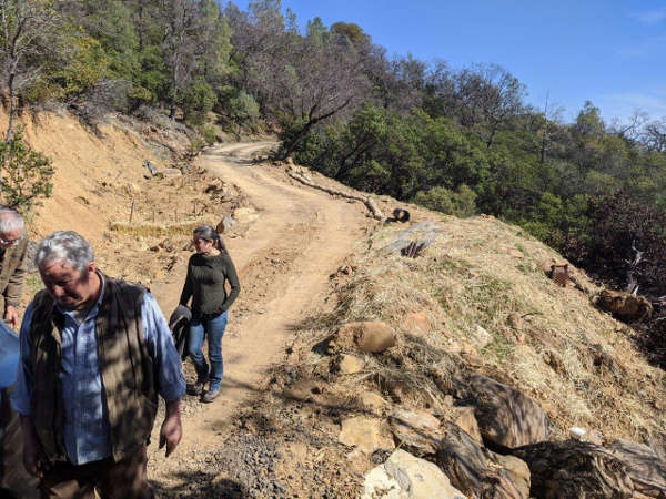
Tuleyome also recently completed a project funded by Napa County’s Lake Berryessa Watershed Improvement Program to improve nearly three miles of Oat Hill Mine Road, which passes by several mercury mines (including Corona and Twin Peaks).
The road, first constructed in 1867 for stagecoaches, ran into disrepair when the alternative toll road became a free public highway in 1924 and large-scale mining operations along the roadway ceased.
Most culverts were undersized and improperly installed, frequently failing during heavy rains. After culverts plugged, runoff flowed down the dirt road, scouring channels and washing away berms.
Tuleyome’s project team designed and constructed durable road improvements to reduce erosion (of mercury-rich sediment) and localized flooding, leading to better water quality downstream and access to the mine sites and road network.
This project also supported the planned Napa County Open Space Trail System and public primitive campground, potentially connecting to the popular Oat Hill Mine Trail.
What’s next?
Regional water managers recently completed a project to identify and prioritize all of our region’s mercury mine sites, and then to conduct detailed site assessments and produce cleanup plans for a select few. Several stakeholders are now considering how to address those sites.
Tuleyome is also proposing to improve roads in a designated off-highway vehicle use area near Knoxville (in the Lake Berryessa watershed and beside a UC Davis reserve).
As for the recent road improvement project, these planned efforts will reduce mercury-laden soil erosion from contaminating local waterways and the lake.
For more information, visit www.tuleyome.org/projects/mercury-mine-remediation-program.
Stephen McCord is president of McCord Environmental, based in Davis, California. As a registered professional engineer, he has more than 25 years of consulting, research and teaching experience in the environmental engineering field throughout the US and internationally. Dr. McCord has managed Tuleyome’s mercury cleanup projects since 2011. Tuleyome is a nonprofit, nonpartisan organization that engages in advocacy and active stewardship with diverse communities to conserve, enhance, restore and enjoy the lands in the region.