 How to resolve AdBlock issue?
News
- Details
- Written by: Teresa A. Sullivan, University of Virginia

A few days ago, I completed my 2020 U.S. census form.
My latest book details the fundamentals and significance of the 2020 census. By April 1, every residence in the United States will be contacted, usually by mail, to answer only seven questions. This year you may respond online, although there are options for paper, telephone and even talking to a census worker.
Special efforts will be launched to reach the homeless, people in transit and those living in unconventional housing, such as a houseboat. The census will cost billions of dollars.
All this effort and expense raises the issue of whether there is an alternative. The short answer is no, not unless the U.S. Constitution is amended.
Other countries, however, have different ways of counting and tracking their populations. The U.S. system is moving in their direction.
Is there a better way?
The census is required by the U.S. Constitution to apportion the House of Representatives according to the population of the states. Census data are used to allocate federal funding, some US$1.5 trillion of it, to states and localities.
Undercounting just one child in poverty may cost a school district nearly $1,700 a year in Title I funds. According to one study, the people most likely to be undercounted are often the very people who would benefit the most from Medicaid and other programs.
The census is a snapshot of the country’s population. The nature of a snapshot is that it is fixed at a point in time. According to the U.S. Constitution, that snapshot is taken once every 10 years.
The census will not change or go away unless the U.S. Constitution is amended, a lengthy process requiring the agreement of a supermajority of both Houses of Congress and three-fourths of the state legislatures. However, a continuous population register would be one alternative, perhaps enhanced with an occasional “light-touch” census supplementing the register information with just a few questions asked at long intervals.
In reality, however, the population is more like a video, with people moving in and out as they are born and die and change residences in between those two events. A continuous population register is more like a video than a snapshot, with every birth, death and move tracked for every resident.
How population registers work
Population registers – which require citizens to keep a current address with the government and to register births and deaths – have existed for centuries in parts of Asia and Europe, especially in Scandinavia.
Population registration in China dates back at least to the Han dynasty (206 B.C. - A.D. 220). Later, birth and death registration laws were part of the T'ang codes, one of China’s earliest recorded legal codes.
The Japanese system of registration, which was adapted from China, featured distinctive household registries that were intended to be the basis of periodic land reallocation in the seventh century A.D. – though it isn’t clear that Japan ever used the data in this way. National registration was restored and strengthened during the Tokugawa shogunate in the 1600s.
The European origins of registries were parish records of baptisms, marriages and burials. Later, the nation-state coordinated the registry, including the movement of citizens from one place to another.
Today, the registries are digitized. As I note in my latest book, the Swedish tax authority, for example, maintains the registry for Sweden, and Swedes have unique PINs and the right to see anything in their file.

Just the census – for now
According to a working paper developed for the U.S. Census Bureau, the United States knows how many people are born and die every year with high accuracy.
For most of the U.S. population – at least those who are reached by the IRS, Social Security or Medicare – it is highly likely that the federal government has their address. There are some potential barriers to using a population register, because tracking births and deaths is a responsibility of individual states, but the states cooperate with the federal government in compiling vital statistics.
The biggest flaw with the population register is keeping accurate track of international migration.
Entry into the United States might go undetected, or a visa may expire. Emigrants are not required to notify the United States that they have relocated to another country, and the U.S. does not employ exit visas.
Even if “net migration” – immigrants minus emigrants – is estimated for the country as a whole, the state or locality where people have entered or left may be unknown. This would be important information for local governments that must provide roads, police and fire service, and other services for all.
This year, the U.S. Census Bureau will use an unprecedented amount of administrative data, such as Social Security records, to check the accuracy of census data, to edit missing information and to estimate the citizenship status of respondents. This latter use of administrative data has been mandated by a presidential executive order to ascertain citizenship, after the Supreme Court prevented a citizenship question being put on the 2020 census.
So, while there is not yet a population register, it might be at America’s doorstep. In the meantime, however, please complete your census form – it is your democratic duty.
[Like what you’ve read? Want more? Sign up for The Conversation’s daily newsletter.]![]()
Teresa A. Sullivan, Interim Provost, Michigan State University and President Emerita and University Professor, University of Virginia
This article is republished from The Conversation under a Creative Commons license. Read the original article.
- Details
- Written by: Lake County News reports
The California State Association of Counties is the voice of California’s 58 counties at the state and federal level.
That organization, along with the California Association of County Treasurers and Tax Collectors, on Saturday addressed the COVID‐19 crisis and the April 10 property tax deadline.
“Taking care of Californians is our top priority, and counties, cities, and schools are burning through local reserves to do so. Any delay in payments beyond the April 10 property tax deadline, for individuals or businesses that can pay, will tip local governments into insolvency at a time when our residents need us the most,” the associations said in a joint statement.
“Counties will use all existing authority to cancel penalties and other charges for homeowners, small businesses and other property owners that are unable to pay their property taxes due to circumstances caused by COVID‐19 on a case‐by‐case basis. However, property owners who can pay or that haven’t been directly affected by COVID‐19, including international corporations and out‐of‐state landlords, still need to pay on time to keep critical government services running,” the associations said.
The associations said property taxes only go to local governments – schools, counties, cities and special districts – not to the state or federal government, and directly fund education, health care, hospitals, welfare services, fire protection and efforts to address homelessness efforts, to name a few.
“Delaying the April 10 property tax payment would take tens of billions of dollars away from local
government, create cash flow problems, and cause some to default on their loans, which would have significant long‐term effects on all local agencies in California,” the associations said.
Gov. Gavin Newsom responded on Saturday with praise for the commitment to cancel penalties and other charges for those with demonstrated economic hardship.
“This is good news for Californians. I would like to thank the California State Association of Counties and the California Association of County Treasurers and Tax Collectors for committing to providing economic relief for residents and small businesses facing hardships due to COVID-19,” said Gov. Newsom.
- Details
- Written by: NATIONAL AERONAUTICS AND SPACE ADMINISTRATION
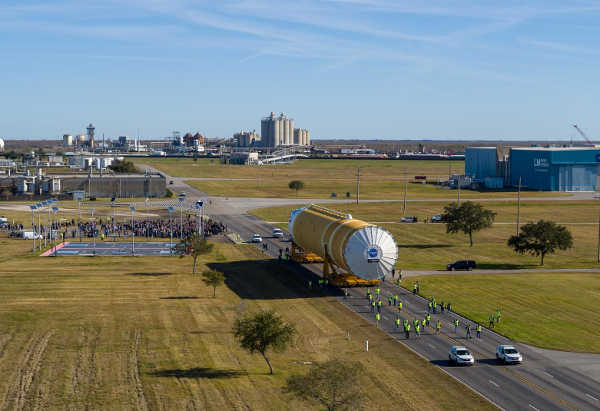
As NASA prepares for the first launch of Artemis I, the first mission of the agency’s Space Launch System, or SLS, rocket and Orion spacecraft to the Moon, one team will be there every step of the way: the aptly nicknamed “SLS Move Team.”
Based out of NASA’s Marshall Space Flight Center in Huntsville, Alabama, the move team ensures all the flight hardware for the SLS rocket’s core stage is safely and efficiently transported from the site where it was manufactured to various test facilities and – ultimately – to its future launch site. From the very beginning, the move team has been an integral part of the SLS Program.
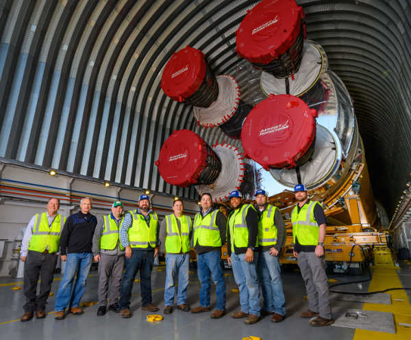
“Marshall’s Ground and Marine Transportation teams are responsible for the handling and transportation of the SLS rocket’s core stage, which is the largest rocket stage NASA has assembled, tested and transported since the Apollo Program,” said Robert Rutherford, transportation and logistics engineering group lead at Marshall. “We started logistics planning for both the moves of structural test articles of the individual elements and for the entire Artemis I core stage early on in the program.”
While the full team is divided between ground and marine activities, together they typically operate as one cohesive unit to successfully transport the large hardware for the megarocket’s 212-foot-tall core stage. The huge stage includes two giant propellant tanks and four RS-25 engines, each the size of a compact car.
The teams’ coordination and efforts were prominently displayed as the first SLS rocket core stage was rolled out from NASA’s Michoud Assembly Facility in New Orleans to the agency’s Pegasus barge on Jan. 8, then transported by Pegasus from New Orleans to nearby NASA’s Stennis Space Center near Bay St. Louis, Mississippi, for the core stage Green Run test series.
Once the barge and flight hardware arrived at Stennis, the Ground Operations team was again at work, helping to prepare, lift and install the flight hardware into the B-2 Test Stand for the test campaign.
“The effort to move the SLS rocket’s core stage from Michoud to Stennis and installing it into the B-2 Test Stand is a result of extensive preparation,” said Bryan Jones, logistics engineering and ground transportation team lead at Marshall. “It was a true team effort. Without the support of all parties that play a part in the operations, we would not be able to be successful.”
The Ground and Marine Transportation teams have been vital in shipping four structural test articles from Michoud to Marshall for testing. The teams prepared for the move of actual flight hardware with SLS pathfinders during the spring and summer of 2019.
The ground and marine teams spend months meticulously planning and developing detailed transportation move procedures to ensure test articles and flight hardware alike are delivered without a mishap. They use a myriad of specialized equipment, including transporters specifically designed to accommodate and hold the hardware, and Pegasus.
The now 310-foot-long barge was modified and refurbished in 2015 to successfully ferry the SLS core stage, which is more than 50 feet longer than the space shuttle external tank and – when including ground support and transportation equipment -- more than 600,000 pounds heavier. The shuttle’s external tanks were frequent passengers aboard Pegasus during the shuttle era of space exploration.
“Each member of the team understands the privilege and responsibility that NASA’s ground and marine transportation teams have been given in handling hardware that will enable the United States to send American astronauts to the Moon and on to Mars,” said Alan Murphy, team lead of marine operations for Pegasus. “The key to preparation for the Pegasus crew is in the vessel itself. Pegasus has the capacity to carry each of the individual core stage elements in addition to the actual core stage.
The size of the SLS core stage pathfinder and the flight hardware core stage, although massive, did not intimidate the Pegasus crew as we leaned on our experience from shipping the four structural test articles,” he added.
Like their counterparts in ground transportation, the Pegasus crew prepared to ship the larger, much heavier fully assembled core stage by delivering structural test articles and pathfinders to different NASA centers. Pegasus made the first delivery of the Artemis program to NASA’s Kennedy Space Center in Florida with the core stage pathfinder, a full-scale replica of the stage, in September 2019.
The Ground and Marine Transportation teams coordinate their efforts with numerous other NASA organizations and dozens of agencies, including the Tennessee Valley Authority, Corps of Engineers, Coast Guard and National Oceanic and Atmospheric Administration, to get the hardware from one NASA facility to another.
“Before NASA transports any hardware, teams meet to consider every aspect of the move from the strength of the roadways to the weather the day of the move,” Rutherford said. “Because of the SLS core stage’s height, weight, width and length, special combinations and modifications had to be made to roads, docks, even power lines, and to the barge itself, to accommodate the total weight and width of the rocket hardware.”
Hours of work go into planning and executing the various dynamics of transporting, loading and handling the flight hardware. However, the final factor for consideration before any move begins is usually the most unpredictable: the weather. Following the arrival of Pegasus and the core stage for Artemis I to Stennis for the Green Run test series, crews spent several days assessing the wind and rain factors at and above ground level before lifting and installing the rocket stage into the test stand.
While the core stage undergoes Green Run testing at Stennis, Ground and Marine Transportation teams will be at work to ship the launch vehicle stage adapter, the part of the rocket that connects the core stage to the upper part of the rocket. The hardware will move from Marshall, where it is manufactured, on Pegasus to Kennedy, where engineers will prepare it for integration to the rest of the rocket ahead of the launch of Artemis I.
A rocket as large as the SLS rocket doesn’t arrive to the launch pad fully assembled. Teams will assemble, or stack, the various elements and stages of the SLS rocket inside Kennedy’s Vehicle Assembly Building before moving the fully assembled rocket to the launch pad. As they have done since the beginning, the men and women of Marshall’s ground and marine transportation teams will be on hand to plan and carry out the well-orchestrated effort it takes to transport the various pieces of hardware across the country — and waterways — to Kennedy for the first Artemis launch to the Moon.
NASA is working to land the first woman and the next man on the Moon by 2024. SLS, along with Orion, the human landing system, and the Gateway in orbit around the Moon, are NASA’s backbone for deep space exploration. SLS is the only rocket that can send Orion, astronauts and supplies to the Moon on a single mission.
For more on NASA’s SLS, visit https://www.nasa.gov/sls .
- Details
- Written by: Lake County News reports
The Lake County Office of Education and the district superintendents, after consulting with Lake County Public Health Officer Dr. Gary Pace, agree with those recommendations for the safety of students and the community during this health crisis.
Suspension of in-classroom instruction has become necessary to help Lake County and California “flatten the curve” and slow the spread of COVID-19 so that emergency medical responders have as much time as possible to prepare for an influx of patients and save lives.
Lake County schools will deliver distance-based instruction through the end of the school year, unless the situation improves and warrants a safe return to the classroom as determined by Dr. Pace.
Students and their families will continue to receive specific plans and instructions from their child’s school district regarding ongoing remote learning.
“There is frustration that it has not been possible to determine an exact date to reopen campuses. But as Dr. Anthony Fauci, the United States top infectious-diseases expert says, ‘You don’t make the timeline; the virus makes the timeline,’” said Lake County Superintendent of Schools Brock Falkenberg.
School districts have been hard at work since mid-March building distance learning programs from the ground up to serve students remotely, including English learners and those with disabilities.
LCOE has diligently supported these efforts with virtual, county-wide trainings for educators, as well as individualized support for school districts.
Falkenberg added, “Teachers, support staff, and administrators are working long hours to provide students access to their academic education. They are also providing the social and emotional support that is so necessary during this health crisis.”
Although students may not be returning to campus, school sites will stay open for staff to perform tasks that have been deemed essential by their districts, including the preparation of student meals. In Lake County, every child under the age of 18 can receive these meals. Please check with your local school for details.
Falkenberg added, “I recognize this difficult but necessary decision may cause disappointment. I am a parent of a graduating senior. I understand the disappointment and challenges first-hand.”
Due to the ever-changing nature of this health crisis, please visit www.lakecoe.org/COVID-19 or the Lake County Office of Education Facebook page for up-to-date information.
Please visit your local district website, for information pertaining to specific schools.
Kelseyville Unified School District: www.kvusd.org
Konocti Unified School District: www.konoctiusd.org
Lake County International Charter School: www.lcics.org
Lake County Office of Education: www.lakecoe.org
Lakeport Unified School District: www.lakeport.k12.ca.us
Lucerne Elementary School District: www.lucerne.k12.ca.us
Middletown Unified School District: www.middletownusd.org
Upper Lake Unified School District: www.ulusd.org
For more information about the county response to COVID-19, visit http://health.co.lake.ca.us .