How to resolve AdBlock issue?
Refresh this page
How to resolve AdBlock issue?
Refresh this page
Lake County News,California
  • Home
    • Registration Form
  • News
    • Education
    • Veterans
    • Community
      • Obituaries
      • Letters
      • Commentary
    • Police Logs
    • Business
    • Recreation
    • Health
    • Religion
    • Legals
    • Arts & Life
    • Regional
  • Calendar
  • Contact us
    • FAQs
    • Phones, E-Mail
    • Subscribe
  • Advertise Here
  • Login
How to resolve AdBlock issue?
Refresh this page

News

Which wildfire smoke plumes are hazardous? New satellite tech can map them in 3D for air quality alerts at neighborhood scale

Details
Written by: Jun Wang, University of Iowa
Published: 27 July 2025
Smoke from Canadian wildfires prompted air quality alerts in Chicago as it blanketed the city on June 5, 2025. Scott Olson/Getty Images

Canada is facing another dangerous wildfire season, with burning forests sending smoke plumes across the provinces and into the U.S. again. The pace of the 2025 fires is reminiscent of the record-breaking 2023 wildfire season, which exposed millions of people in North America to hazardous smoke levels.

For most of the past decade, forecasters have been able to use satellites to track these smoke plumes, but the view was only two-dimensional: The satellites couldn’t determine how close the smoke was to Earth’s surface.

The altitude of the smoke matters.

If a plume is high in the atmosphere, it won’t affect the air people breathe – it simply floats by far overhead.

But when smoke plumes are close to the surface, people are breathing in wildfire chemicals and tiny particles. Those particles, known as PM2.5, can get deep into the lungs and exacerbate asthma and other respiratory and cardiac problems.
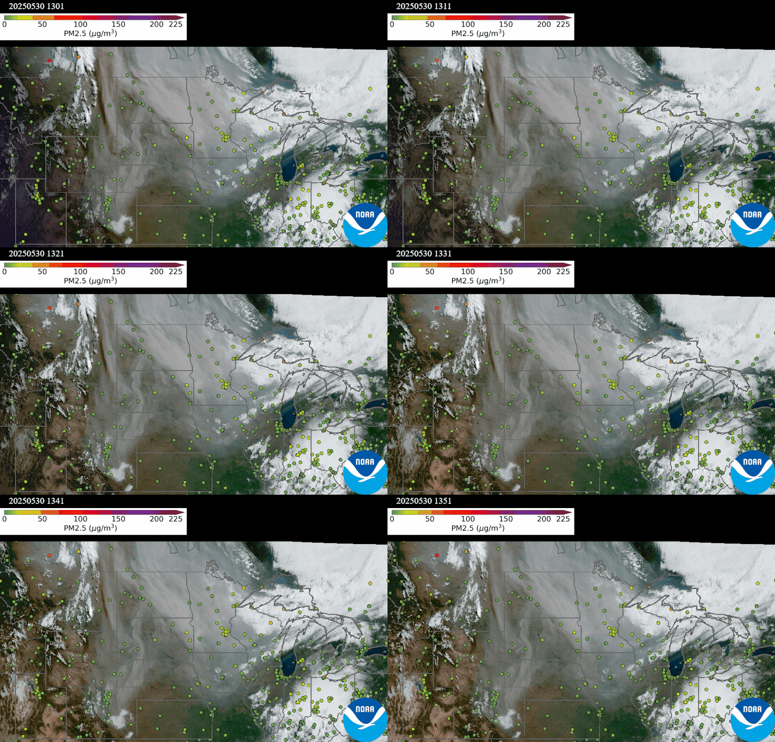
An animation shows mostly green (safe) air quality from ground-level monitors. However, in Canada, closer to the fire, the same plume shows high levels of PM2.5.
An animation on May 30, 2025, shows a thick smoke plume from Canada moving over Minnesota, but the air quality monitors on the ground detected minimal risk, suggesting it was a high-level smoke plume. NOAA NESDIS Center for Satellite Applications and Research

The Environmental Protection Agency uses a network of ground-based air quality monitors to issue air quality alerts, but the monitors are few and far between, meaning forecasts have been broad estimates in much of the country.

Now, a new satellite-based method that I and colleagues at universities and federal agencies have been working on for the past two years is able to give scientists and air quality managers a 3D picture of the smoke plumes, providing detailed data of the risks down to the neighborhood level for urban and rural areas alike.

Building a nationwide smoke monitoring system

The new method uses data from a satellite that NASA launched in 2023 called the Tropospheric Emissions: Monitoring of Pollution, or TEMPO, satellite.

A map shows blue over the Dakotas, Nebraska and western parts of Minnesota and Iowa. Pink is over Pennsylvania up through Maine.
Data from the TEMPO satellite shows the height of the smoke plume, measured in kilometers. Light blue areas are closest to the ground, suggesting the worst air quality. Pink areas suggest the smoke is more than 2 miles (3.2 kilometers) above the ground, where it poses little risk to human health. The data aligns with air monitor readings taken on the ground at the same time. NOAA NESDIS Center for Satellite Applications and Research

TEMPO makes it possible to determine a smoke plume’s height by providing data on how much the oxygen molecules absorb sunlight at the 688 nanometer wavelength. Smoke plumes that are high in the atmosphere reflect more solar radiation at this wavelength back to space, while those lower in the atmosphere, where there is more oxygen to absorb the light, reflect less.

Understanding the physics allowed scientists to develop algorithms that use TEMPO’s data to infer the smoke plume’s altitude and map its 3D movement in nearly real time.

An illustration shows a satellite, Sun and smoke plume at different heights. Higher plumes reflect more light.
Aerosol particles in high smoke plumes reflect more light back into space. Closer to Earth’s surface, there is more oxygen to absorb light at the 688 nanometer wavelength, so less light is reflected. Satellites can detect the difference, and that can be used to determine the height of the smoke plume. Adapted from Xu et al, 2019, CC BY

By combining TEMPO’s data with measurements of particles in the atmosphere, taken by the Advanced Baseline Imager on the NOAA’s GOES-R satellites, forecasters can better assess the health risk from smoke plumes in almost real time, provided clouds aren’t in the way.

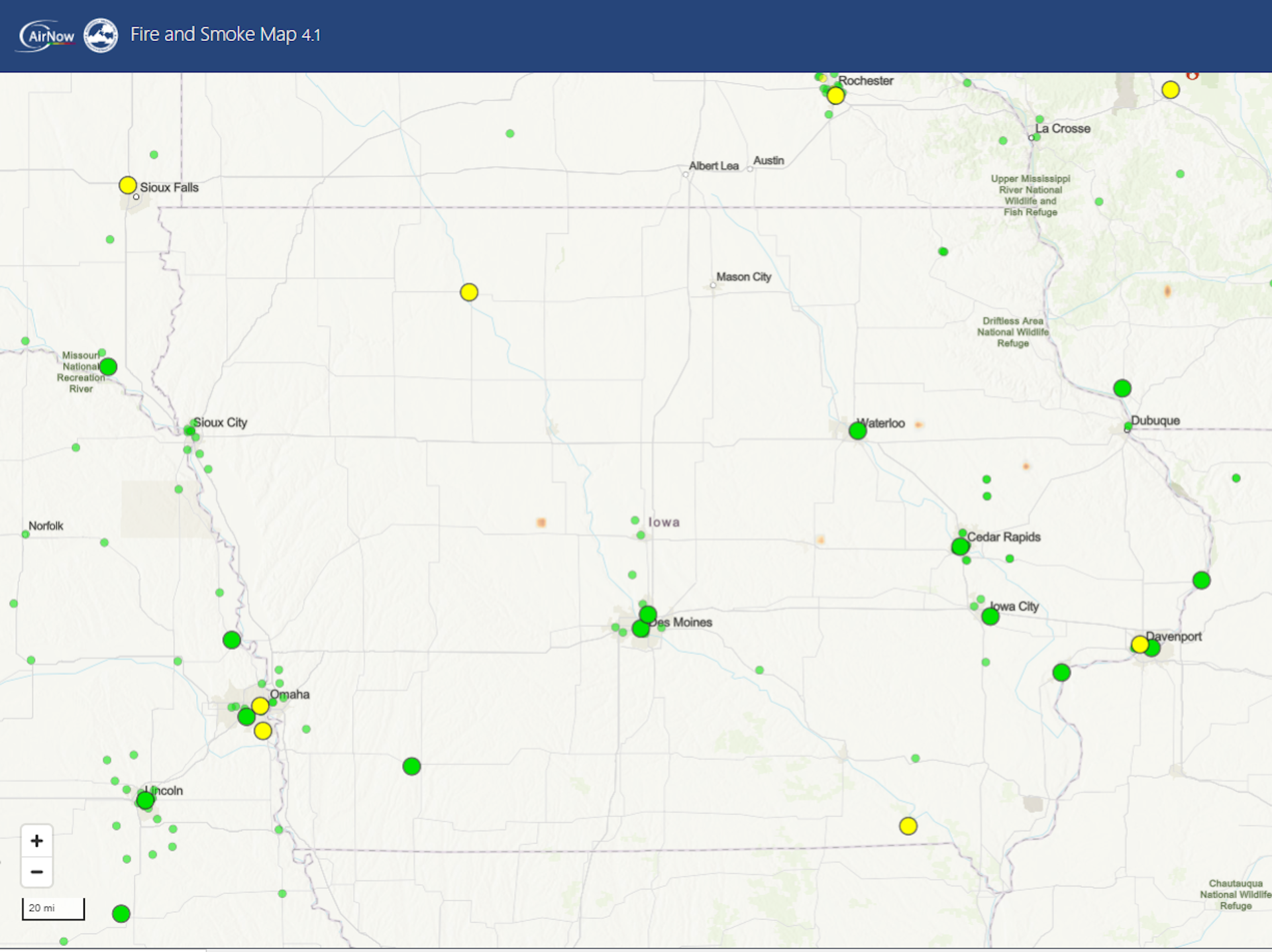
That’s a big jump from relying on ground-based air quality monitors, which may be hundreds of miles apart. Iowa, for example, had about 50 air quality monitors reporting data on a recent day for a state that covers 56,273 square miles. Most of those monitors were clustered around its largest cities.

NOAA’s AerosolWatch tool currently provides a near-real-time stream of wildfire smoke images from its GOES-R satellites, and the agency plans to incorporate TEMPO’s height data. A prototype of this system from my team’s NASA-supported research project on fire and air quality, called FireAQ, shows how users can zoom in to the neighborhood level to see how high the smoke plume is, however the prototype is currently only updated once a day, so the data is delayed, and it isn’t able to provide smoke height data where clouds are also overhead.

Wildfire health risks are rising

Fire risk is increasing across North America as global temperatures rise and more people move into wildland areas.

While air quality in most of the U.S. improved between 2000 and 2020, thanks to stricter emissions regulations on vehicles and power plants, wildfires have reversed that trend in parts of the western U.S. Research has found that wildfire smoke has effectively erased nearly two decades of air quality progress there.

Our advances in smoke monitoring mark a new era in air quality forecasting, offering more accurate and timely information to better protect public health in the face of these escalating wildfire threats.The Conversation

Jun Wang, Professor of Chemical and Biochemical Engineering, University of Iowa

This article is republished from The Conversation under a Creative Commons license. Read the original article.


Helping Paws: French bulldogs, terriers and shepherds

Details
Written by: Elizabeth Larson
Published: 27 July 2025

LAKE COUNTY, Calif. — Lake County Animal Care and Control has many beautiful dogs of all ages waiting to be adopted this week.

The dogs available for adoption this week include mixes of border collie, French bulldog, German shepherd, husky, Labrador Retriever, pit bull terrier, terrier and shepherd.

Dogs that are adopted from Lake County Animal Care and Control are either neutered or spayed, microchipped and, if old enough, given a rabies shot and county license before being released to their new owner. License fees do not apply to residents of the cities of Lakeport or Clearlake.

Those animals shown on this page at the Lake County Animal Care and Control shelter have been cleared for adoption.

Call Lake County Animal Care and Control at 707-263-0278 or visit the shelter online for information on visiting or adopting.

The shelter is located at 4949 Helbush in Lakeport.

Email Elizabeth Larson at This email address is being protected from spambots. You need JavaScript enabled to view it.. Follow her on Twitter, @ERLarson, and on Bluesky, @erlarson.bsky.social. Find Lake County News on the following platforms: Facebook, @LakeCoNews; X, @LakeCoNews; Threads, @lakeconews, and on Bluesky, @lakeconews.bsky.social. 

Desiree's preview photo
Desiree

Tiger's preview photo
Tiger

Cub's preview photo
Cub

Diamond's preview photo
Diamond

Sky 's preview photo
Sky

Carmen's preview photo
Carmen

Saphire's preview photo
Saphire

Scrappy's preview photo
Scrappy

Jax's preview photo
Jax

Bear's preview photo
Bear


Kennel #11a's preview photo
Kennel #11a

Kennel #11b's preview photo
Kennel #11b
 
Hunter's preview photo
Hunter

Lucky's preview photo
Lucky
 
Tanner's preview photo
Tanner

Daisy's preview photo
Daisy

Flamingo's preview photo
Flamingo

Helen's preview photo
Helen

Bruce's preview photo
Bruce

Kennel#16b's preview photo
Kennel#16b

Kennel#16c (red collar)'s preview photo
Kennel#16c (red collar)

Kennel#16d (green)'s preview photo
Kennel#16d (green)

Duke's preview photo
Duke
 
Carra's preview photo
Carra

Max's preview photo
Max

Remmy's preview photo
Remmy

Mara's preview photo
Mara

Tia's preview photo
Tia

Hamster's preview photo
Hamster

Kennel#15A's preview photo
Kennel#15A

Kennel#7's preview photo
Kennel#7

Kennel#22B's preview photo
Kennel#22B

Kennel#20's preview photo
Kennel#20

Kennel#22A's preview photo
Kennel#22A

Kennel#15B's preview photo
Kennel#15B

Kennel#4's preview photo
Kennel#4

 
Zora's preview photo
Zora

Kennel#19 's preview photo
Kennel#19

Billy's preview photo
Billy
 
Kennel#34's preview photo
Kennel#34

Space News: Binary star systems are complex astronomical objects − a new AI approach could pin down their properties quickly

Details
Written by: Andrej Prša, Villanova University
Published: 27 July 2025

In a binary star system, two stars orbit around each other. ESO/L. Calçada, CC BY

Stars are the fundamental building blocks of our universe. Most stars host planets, like our Sun hosts our solar system, and if you look more broadly, groups of stars make up huge structures such as clusters and galaxies. So before astrophysicists can attempt to understand these large-scale structures, we first need to understand basic properties of stars, such as their mass, radius and temperature.

But measuring these basic properties has proved exceedingly difficult. This is because stars are quite literally at astronomical distances. If our Sun were a basketball on the East Coast of the U.S., then the closest star, Proxima, would be an orange in Hawaii. Even the world’s largest telescopes cannot resolve an orange in Hawaii. Measuring radii and masses of stars appears to be out of scientists’ reach.

Enter binary stars. Binaries are systems of two stars revolving around a mutual center of mass. Their motion is governed by Kepler’s harmonic law, which connects three important quantities: the sizes of each orbit, the time it takes for them to orbit, called the orbital period, and the total mass of the system.

I’m an astronomer, and my research team has been working on advancing our theoretical understanding and modeling approaches to binary stars and multiple stellar systems. For the past two decades we’ve also been pioneering the use of artificial intelligence in interpreting observations of these cornerstone celestial objects.

Measuring stellar masses

Astronomers can measure orbital size and period of a binary system easily enough from observations, so with those two pieces they can calculate the total mass of the system. Kepler’s harmonic law acts as a scale to weigh celestial bodies.

An animation of a large star, which appears stationary, with a smaller, brighter star orbiting around it and eclipsing it when it passes in front.
Binary stars orbit around each other, and in eclipsing binary stars, one passes in front of the other, relative to the telescope lens. Merikanto/Wikimedia Commons, CC BY-SA

Think of a playground seesaw. If the two kids weigh about the same, they’ll have to sit at about the same distance from the midpoint. If, however, one child is bigger, he or she will have to sit closer, and the smaller kid farther from the midpoint.

It’s the same with stars: The more massive the star in a binary pair, the closer to the center it is and the slower it revolves about the center. When astronomers measure the speeds at which the stars move, they can also tell how large the stars’ orbits are, and as a result, what they must weigh.

Measuring stellar radii

Kepler’s harmonic law, unfortunately, tells astronomers nothing about the radii of stars. For those, astronomers rely on another serendipitous feature of Mother Nature.

Binary star orbits are oriented randomly. Sometimes, it happens that a telescope’s line of sight aligns with the plane a binary star system orbits on. This fortuitous alignment means the stars eclipse one another as they revolve about the center. The shapes of these eclipses allow astronomers to find out the stars’ radii using straightforward geometry. These systems are called eclipsing binary stars.

By taking measurements from an eclipsing binary star system, astronomers can measure the radii of the stars.

More than half of all Sun-like stars are found in binaries, and eclipsing binaries account for about 1% to 2% of all stars. That may sound low, but the universe is vast, so there are lots and lots of eclipsing systems out there – hundreds of millions in our galaxy alone.

By observing eclipsing binaries, astronomers can measure not only the masses and radii of stars but also how hot and how bright they are.

Complex problems require complex computing

Even with eclipsing binaries, measuring the properties of stars is no easy task. Stars are deformed as they rotate and pull on each other in a binary system. They interact, they irradiate one another, they can have spots and magnetic fields, and they can be tilted this way or that.

To study them, astronomers use complex models that have many knobs and switches. As an input, the models take parameters – for example, a star’s shape and size, its orbital properties, or how much light it emits – to predict how an observer would see such an eclipsing binary system.

Computer models take time. Computing model predictions typically takes a few minutes. To be sure that we can trust them, we need to try lots of parameter combinations – typically tens of millions.

This many combinations requires hundreds of millions of minutes of compute time, just to determine basic properties of stars. That amounts to over 200 years of computer time.

Computers linked in a cluster can compute faster, but even using a computer cluster, it takes three or more weeks to “solve,” or determine all the parameters for, a single binary. This challenge explains why there are only about 300 stars for which astronomers have accurate measurements of their fundamental parameters.

The models used to solve these systems have already been heavily optimized and can’t go much faster than they already do. So, researchers need an entirely new approach to reducing computing time.

Using deep learning

One solution my research team has explored involves deep-learning neural networks. The basic idea is simple: We wanted to replace a computationally expensive physical model with a much faster AI-based model.

First, we computed a huge database of predictions about a hypothetical binary star – using the features that astronomers can readily observe – where we varied the hypothetical binary star’s properties. We are talking hundreds of millions of parameter combinations. Then, we compared these results to the actual observations to see which ones best match up. AI and neural networks are ideally suited for this task.

In a nutshell, neural networks are mappings. They map a certain known input to a given output. In our case, they map the properties of eclipsing binaries to the expected predictions. Neural networks emulate the model of a binary but without having to account for all the complexity of the physical model.

Neural networks detect patterns and use their training to predict an output, based on an input.

We train the neural network by showing it each prediction from our database, along with the set of properties used to generate it. Once fully trained, the neural network will be able to accurately predict what astronomers should observe from the given properties of a binary system.

Compared to a few minutes of runtime for the physical model, a neural network uses artificial intelligence to get the same result within a tiny fraction of a second.

Reaping the benefits

A tiny fraction of a second works out to about a millionfold runtime reduction. This brings the time down from weeks on a supercomputer to mere minutes on a single laptop. It also means that we can analyze hundreds of thousands of binary systems in a couple of weeks on a computer cluster.

This reduction means we can obtain fundamental properties – stellar masses, radii, temperatures and luminosities – for every eclipsing binary star ever observed within a month or two. The big challenge remaining is to show that AI results really give the same results as the physical model.

This task is the crux of my team’s new paper. In it we’ve shown that, indeed, the AI-driven model yields the same results as the physical model across over 99% of parameter combinations. This result means the AI’s performance is robust. Our next step? Deploy the AI on all observed eclipsing binaries.

Best of all? While we applied this methodology to binaries, the basic principle applies to any complex physical model out there. Similar AI models are already speeding up many real-world applications, from weather forecasting to stock market analysis.The Conversation

Andrej Prša, Professor of Astrophysics and Planetary Science, Villanova University

This article is republished from The Conversation under a Creative Commons license. Read the original article.

California State Parks surveys community on Clear Lake State Park General Plan 

Details
Written by: LAKE COUNTY NEWS REPORTS
Published: 26 July 2025
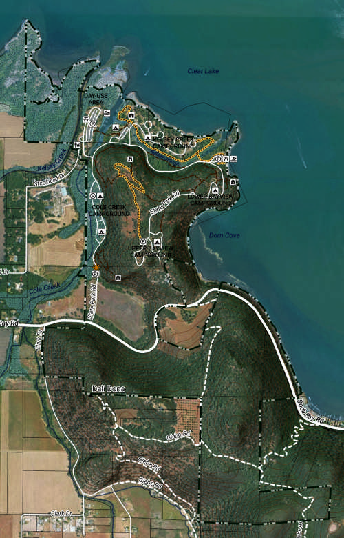
Clear Lake State Park. Courtesy image.


LAKE COUNTY, Calif. — As the process to complete the new Clear Lake State Park General Plan continues, California State Parks is asking the community to participate in a survey to consider new options.

The park hosted its second workshop on the plan on July 16.

At that time, park staff and contractors shared multiple planning concepts — or planning alternatives — and gathered the park community's initial feedback and other ideas.  

These concepts will guide future park improvements and management.  

For those who couldn’t attend the workshop, State Parks is asking them to take part in the online survey, which is available until Aug. 15 on the park website.

The survey lets you review three possible planning options to guide future improvements and management of Clear Lake State Park. 

Explore maps showing different directions and ideas for the park and tell us what matters most to you — from home and at your own pace.

The community engagement section of this website provides more information about the community engagement efforts and a link to download the draft planning alternatives.

“These alternatives are discussion starters, and we need your feedback to identify what resonates, what's missing, and what new ideas should be considered for Clear Lake State Park's future,” Park staff said.

View detailed maps of each alternative with proposed trails, facilities and management actions here.

For more information, email This email address is being protected from spambots. You need JavaScript enabled to view it. or visit www.parks.ca.gov/CLSP_GP. 

  1. Padilla announces bill to reopen lawful pathway to legalization, countering cruel mass deportation agenda
  2. Signed, sealed and delivered for 250 years: USPS marks a milestone with two new stamp releases
  3. CDFW completes 2025 Waterfowl Breeding Population Survey
  • 277
  • 278
  • 279
  • 280
  • 281
  • 282
  • 283
  • 284
  • 285
  • 286
How to resolve AdBlock issue?
Refresh this page