NORTH COAST, Calif. — Authorities arrested two Lucerne women this week who they said were responsible for a series of vehicle burglaries in Ukiah.
Mendocino County Sheriff’s deputies arrested Elizabeth Arnold, 39, and Sarah Simon, 48, early Tuesday morning.
The agency said that at 12:42 a.m. Tuesday, deputies were dispatched to investigate two suspicious subjects entering people's vehicles in the 3000 block of Estrella Court in Ukiah.
Upon arrival at the scene, deputies immediately observed a female who was driving a vehicle at a slow speed with all of the lights turned off. The female was stopped by deputies and identified as Sarah Simon.
Deputies also observed another female hiding behind a nearby vehicle in the driveway of a residence, who was identified as Elizabeth Arnold.
Both Simon and Arnold were detained, and deputies began their investigation by canvassing the neighborhood.
The deputies located multiple vehicles in the area with the doors open. Deputies contacted the homeowners where the vehicles were parked and learned several items had been stolen from the vehicles.
A search of Arnold, Simon and their vehicle revealed numerous items that had just been stolen, the sheriff’s office said.
Simon was also in possession of a controlled substance and drug paraphernalia, and had an active warrant for her arrest out of Lake County for petty theft with two priors.
During their investigation, the deputies learned both Arnold and Simon were also suspects in similar thefts of numerous items taken from vehicles in the nearby neighborhoods of West Fork Estates and Lake Mendocino Estates, which occurred in the early morning hours of Feb. 18.
Sheriff’s detectives assisted with this investigation and gathered additional evidence and statements which led to the execution of search warrants for additional stolen property.
In all, authorities said investigators determined there were five victims of the Tuesday burglaries.
During the investigation, Simon was placed under arrest for her felony arrest warrant out of Lake County, along with charges of felony conspiracy, possession of paraphernalia and possession of a controlled substance.
Arnold was placed under arrest for felonies of conspiracy and grand theft.
Simon was subsequently booked into the Mendocino County Jail where she was to be held in lieu of $10,000 bail for the Lake County warrant and $15,000 bail for the current open charges.
Arnold was booked into the Mendocino County Jail where she was to be held in lieu of $15,000.00 bail.
Anyone with information related to this investigation and thefts is requested to contact the Mendocino County Sheriff’s Office Dispatch Center at 707-463-4086 (option 1).
LAKEPORT, Calif. — The California Highway Patrol has issued a report on a wreck earlier this week that claimed the life of a Lakeport man.
The crash, which took place just before noon on Sunday, led to the death of 88-year-old Edmund Joseph Slevin.
The CHP’s Clear Lake Area office said that at 11:50 a.m. Sunday, Slevin was driving his Hyundai southbound on Lakeshore Boulevard south of Rainbow Drive at an unknown speed.
Amely Ballesteros, 21, of Lakeport was driving a Jeep at a stated speed of 30 to 35 miles per hour, traveling northbound on Lakeshore Boulevard north of Beach Lane, approaching Slevin’s vehicle.
She saw Slevin’s Hyundai drift across the roadway centerline towards oncoming traffic, narrowly missing the vehicle in front of her, the CHP said.
The left front corner of Slevin’s Hyundai struck the left side of Amely Ballesteros’ Jeep, causing the Jeep to spin about where it came to rest, on its wheels, facing a southwesterly direction in front of a residence, according to the CHP report.
The CHP said Slevin’s vehicle continued further onto the northbound shoulder towards a residence, where it came to rest against a water main, facing in a south-easterly direction.
Slevin was unresponsive at the scene and did not regain consciousness, the CHP reported.
The report said Slevin was transported to Sutter Lakeside for medical treatment. Emergency room staff at Sutter Lakeside ultimately exhausted efforts to revive him and pronounced him deceased just after 1 p.m., the CHP said.
The CHP report said Ballesteros was uninjured.
Email Elizabeth Larson at This email address is being protected from spambots. You need JavaScript enabled to view it.. Follow her on Twitter, @ERLarson, and on Bluesky, @erlarson.bsky.social. Find Lake County News on the following platforms: Facebook, @LakeCoNews; X, @LakeCoNews; Threads, @lakeconews, and on Bluesky, @lakeconews.bsky.social.
This week, California completed its first phase of the new deliberative democracy platform, Engaged California.
Those who subscribed to participate in the first use case, focusing on Los Angeles fire recovery efforts, received invites to join the discussion.
Officials called this is a significant milestone in a brand-new program for the state of California.
Visitors to engaged.ca.gov will also find a new section of the website that informs survivors of the different phases in this process and where they can be involved. It sets a visual detail of the timeline and expectations for the outcome.
“The initial response from Californians has shown us that we need to create different options for how people interact with us. We’re now moving forward into a listening mode and bringing people together for a conversation that can help us change how we normally do things — which is exactly what Engaged California is supposed to do,” said Gov. Gavin Newsom.
This marks a major achievement in creating a new option for Californians to have their voices heard. People who opted into the conversation are now engaging with each other and starting to set the priorities for the deliberation. Invitations take participants into the space where they answer questions, can vote in favor of comments left by others, and respond to other comments. Participation in the space is anonymous and open for a limited time.
“Fire survivors are now actively communicating with us. And California is actively listening,” said California Government Operations Secretary Nick Maduros. “What we are seeing is the shaping of the conversation around recovery efforts from the people who are closest to the need.”
What is Engaged California?
Engaged California is a new platform that gives Californians a unique opportunity to share their thoughts and connect with other people on topics that are important to them.
It creates new opportunities for Californians to connect with their government to inform and shape policy through honest, respectful discussions.
The program was launched In February with the first use case focusing on the impacts of the Los Angeles wildfires.
Ongoing conversations help keep policies useful and up to date by reflecting the ideas and needs of the community, rather than solely relying on one round of feedback.
Engaged California represents a deep collaboration between California and the Carnegie Endowment for International Peace.
"Carnegie California is grateful to be on the ground floor, providing our expertise to inform the development of California's deliberative democracy program,” said Ian Klaus, founding director of Carnegie California. "It is wonderful that California is committed to grounding this work in best practices from knowledge partners in the state and around the globe to improve public engagement and strengthen democracy with digital tools."
This program was modeled after the successful efforts led by Audrey Tang, Taiwan's first Minister of Digital Affairs.
Speaking on a panel at SXSW 2025, Tang highlighted how technology can enhance civic engagement. She pointed to California’s role in leading this shift in the United States.
“Just a couple of weeks ago, Governor Newsom of California announced Engaged California with the same idea about plural listening on a very urgent topic—of how to recover from the wildfire in Eaton and Palisades in LA, and more topics afterwards,” Tang said. “So, we're now seeing a new wave grounded in individual ideas that people have, and resonance people have with each other, without AI stepping in to replace a human's role in decision making."
The long-term goal is to create a sustainable model for deliberative democracy that can be used to discuss other significant issues in California.
Want to join?
Getting involved is simple, and your voice can make a real impact. And remember, this isn’t just a one-time input.
Engaged California is a platform for ongoing dialogue where your ideas are heard and shared.
Stay tuned and get ready to participate. Sign up now at engaged.ca.gov to join the conversation.
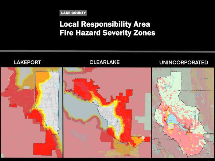
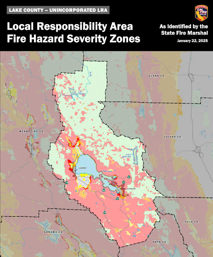
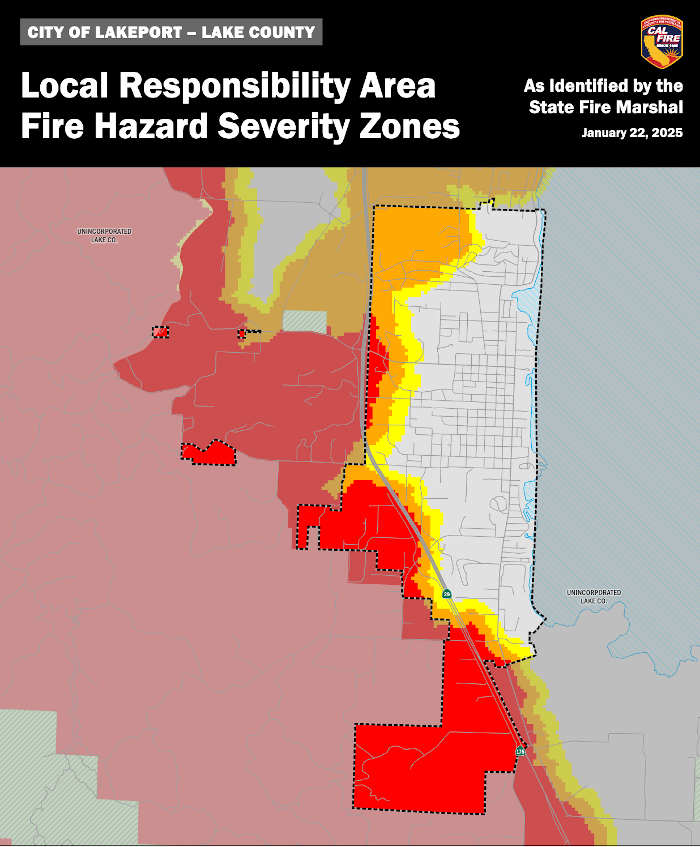
LAKE COUNTY, Calif. — Lake County officials have continued to raise concerns about a new fire hazard map released by Cal Fire that has determined that thousands more acres of the county are at a higher fire threat.
On Feb. 10, Cal Fire released its new fire hazard severity zone map for “Local Responsibility Areas,” adding a total of 14,000 acres of Lake County land to the 'very high' fire hazard severity zone.
State law defines Local Responsibility Areas, or LRA, as “Areas of the state in which the financial responsibility of preventing and suppressing fires is the primary responsibility of a city, county, city and county, or district.”
The new map has entered a 90-day public comment period that began Feb. 12 and ends May 13.
Local governments are required to adopt the map by ordinance in 120 days; their deadline is July 1.
County and city officials, however, fear the new map could have major implications for the county, particularly in relation to fire insurance. They also have questioned the fact that the ratings on the map cannot be altered, regardless of local mitigation efforts.
This is not the first time that Lake County has dealt with concerns about the fire hazard severity zone map.
The Office of the State Fire Marshal is required by law to classify both the state and local responsibility areas into moderate, high and very high fire hazard severity zones.
In April 2024, the updated mapping for State Responsibility Areas went into effect, despite local opposition expressed during the public hearing at the Lake County Board of Supervisors meeting.
Then, in December, local officials — including supervisors, fire chiefs and city managers — were informed that the updated map for the LRA would soon be rolled out.
Regarding how federal lands might be impacted, the Bureau of Land Management said it coordinates with Cal Fire on wildland fire management throughout California and is jointly part of the California Wildfire & Forest Resilience Task Force, “working together to prevent catastrophic wildfires and manage healthy lands.”
“We defer to Cal Fire for more information about new fire hazard severity maps,” the agency told Lake County News about its involvement in the process.
‘Very high’ category significantly expanded
The release of the new LRA map marks its first update since 2011.
Compared to the 2011 version, this new map significantly expands the “very high” acreage in Lake County.
In Clearlake, the acreage rated as “very high” increases from 1,583 to 4,054 acres. In Lakeport, it rises from zero to 603 acres.
Meanwhile, unincorporated areas under county jurisdiction see the most dramatic jump, from just 5 acres to 10,881 acres.
Overall, the total acreage classified as "very high" has grown by 13,950 acres — from 1,588 to 15,538 acres — a total increase of approximately 878%.
In addition, the 2011 map was only required to show the “very high” category. The new map, however, also displays local areas rated moderate and high.
In December 2022, Cal Fire released an updated map for State Responsibility Areas or the SRA, classifying 366,812 acres in Lake County as "very high" fire hazard zones, accounting for 92% of the total acreage under SRA.
Lake County did not welcome it.
In January 2023, during a Cal Fire public hearing at a Lake County Board of Supervisors meeting, local officials, including supervisors and Lakeport Fire Chief Patrick Reitz, and the public voiced opposition, citing concerns about the map’s methodology and potential impacts on fire insurance.
Despite unanimous criticism during the meeting, Cal Fire proceeded with adoption in April 2024.
California Insurance Commissioner Ricardo Lara also claimed that the maps are intended to “drive local planning decisions, not insurance decisions.”
“Fires are real,” said District 2 Supervisor Bruno Sabatier, acknowledging the necessity for Lake County to mitigate fire risks. “So we need to do good work to prevent fires from happening.”
However, local officials remain concerned about the map’s impact on fire insurance availability and rates in the already strained local market, particularly given Lara's recent policy that allows insurance companies to utilize “catastrophic models’ in setting rates.
“It’s not pragmatic for people who are living here,” said Sabatier of the map. “This is gonna have a huge impact."
“The fear is that it's just going to make insurability in the city much more difficult,” said Clearlake City Manager Alan Flora.
While the public comment period is underway, local government and fire leaders also are raising concerns about the mandatory and restrictive adoption process of the map.
Local governments must adopt the map as is or with a higher hazard severity rating, regardless of public input or fire mitigation efforts.
“It's kind of the state jamming this down everybody's throat,” said Reitz before the map was rolled out during a Lakeport Fire District board meeting in January.
A Feb. 12 county press release confirmed that local jurisdictions must approve the map by ordinance before July 1. It also stated that state government code does not allow any adjustment to a lower rating in the map.
The public can now direct questions about the maps to the Office of the State Fire Marshal at This email address is being protected from spambots. You need JavaScript enabled to view it. or by calling 916-633-7655.
Public comment can be submitted to the county and two city councils:
• City of Clearlake: 14050 Olympic Drive, Clearlake. Email comments that apply within the city of Clearlake to: This email address is being protected from spambots. You need JavaScript enabled to view it. or call City Manager Alan Flora at 707-994-8201. • City of Lakeport: 225 Park St., Lakeport. Email comments that apply within the city of Lakeport to: This email address is being protected from spambots. You need JavaScript enabled to view it. or call City Manager Kevin Ingram at 707-263-5615, Extension 102. • County of Lake: 255 N Forbes St., Lakeport, Third Floor, Community Development Department. Email comments for County Jurisdiction areas to: This email address is being protected from spambots. You need JavaScript enabled to view it. or call Director Mireya Turner at 707-263-2382.
Public comment will close on May 13, according to Lake County Community Development Director Mireya.
The Lake County Board of Supervisors, City Councils of Lakeport and Clearlake will also host public hearings on the map. Exact dates have not yet been announced.
Detailed maps for the three jurisdictions in Lake County can be found here. More information can be found on Cal Fire’s webpage, under the “Local Responsibility Area Fire Hazard Severity Zone Map” tab.
Concerns raised over map’s modeling method
For the map makers, the fire hazard severity zone maps are intended to reduce fire threat by ensuring building code compliance.
According to Cal Fire, the maps assess fire hazard based on “the physical conditions that create a likelihood and expected fire behavior over a 30 to 50-year period.”
Such long-term projection does not consider mitigation measures such as home hardening, recent wildfire or fuel reduction efforts.
When asked if zone ratings could change based on such efforts, Jim McDougald, assistant deputy director of Cal Fire’s Community Wildfire Planning & Risk Reduction, said it’s unlikely.
“It looks at the long term fire hazard; it’s the landscape and what it looks like,” McDougald told Lake County News. “So very few things change the map.”
Significant changes, he explained, happen only when wildland is developed into urban space. “There can be small changes, but you don’t see drastic changes unless it’s been built out,” he said.
“The only important part is, when people build in the wild land, we want them to build the appropriate mitigations to protect their home and their investment, right?” he said of the map’s intent. “That's what the maps are designed to do.”
“It's designed for where there's a hazard and where you need to have these building mitigations or defensible space,” he added.
But for Supervisor Sabatier, the problem is that such work of mitigation “doesn’t have any impacts on this map,” he told Lake County News.
A brief discussion was brought up in the Clearlake City Council’s Feb. 20 meeting about Woodland Community College Lake County campus’ fire mitigation effort after suffering smoke damage from the Boyles Fire that started last September.
Mayor Russ Cremer said that the campus went on to remove all trees and overhangings within five feet of their structures.
But still, that didn’t change the rating on the map.
“They did an enormous amount of work removing vegetation. You would expect that maybe you would get some credit or benefit from this mapping process as a result of that mitigation work,” Flora said during the meeting. “It's not gonna happen.”
As for future updates for the map, McDougald said there is no fixed timeline but estimated it would be “at least five years” before another revision.
“It’s been a long time since we updated them,” said McDougald of the 14 years between now and 2011 when the LRA map was last updated.
Still, Sabatier finds it difficult to reconcile that the map projects fire behavior over decades but is updated far more frequently than every 30 to 50 years.
“If you're going to redo these maps every five years, then why don't you just model five years?” he said. “It would make sense to me to model until the next one.”
Worries over fire insurance
When asked if the insurance companies can make their policies based on the maps, McGourald said, “They’re not supposed to. No.”
He emphasized that the map was designed “strictly around building fire-safe homes — it’s what it's for.”
But local officials worry its real-world impact may extend beyond that intent.
“We knew that folks in the unincorporated area outside of these LRAs were already experiencing some pretty tragic increases, if not complete denial for their home insurance,” said Supervisor Sabatier during a phone interview with Lake County News.
“And this will have a much deeper impact in the residential areas especially,” he added of the new LRA map.
Lakeport City Manager Kevin Ingram pointed to Commissioner Lara’s new regulations announced in December that allow insurers using catastrophic modeling in their decision making.
The policy Ingram referred to is part of the commissioner’s regulation kit of “expanding coverage for Californians in wildfire-distressed areas” which goes “hand-in-hand with forward-looking wildfire catastrophe models that can better predict future rates,” the commissioner’s Dec. 30 press release stated.
The new rules allow insurers to incorporate wildfire catastrophe models into ratemaking, if they also expand coverage in underserved areas.
For Ingram, that means insurance companies can now “utilize a whole plethora of information such as the fire hazard severity mapping in their decision on setting rates,” he wrote in an email to Lake County News.
“We know that the insurance companies were using them,” said Reitz in a preliminary discussion about the map at the Lakeport city council meeting on Feb. 18.
“But now it is absolutely permitted,” he said.
The Department of Insurance has not responded to Lake County News’ multiple inquiries through emails and phone calls since February on the map’s impact on Lake County residents’ insurance options and rates.
An automated voice message when calling the department’s press communication number says, “For the health and safety of our employees, we have limited the number of staff on-site. This line is being regularly monitored and we will return messages.”
For Flora, it's important to “get the word out,” he said in the Clearlake City Council meeting where “very few people” were in the room.
“Unfortunately the community probably is not going to respond or care about this as much as they should until they get a cancellation notice of their insurance, which, if they do nothing, is going to happen,” Flora said.
Adopting the map: A restrictive mandate
Even with the current 90-day public comment period, local officials feel the process is little more than a formality.
For one, public comment won’t change the fact that the county and cities “must” adopt the map, as required by state law.
It’s not by choice, said Flora, who also used the word “restrictive” to describe the lack of flexibility in the map: “We can increase the severity zones, but we can’t decrease them.”
“It is frustrating to be able to do a lot of mitigation work that still does not impact these severity zones,” Flora added.
“If you have ‘moderate,’ you can make a claim — ‘actually, it’s not moderate, it should be high,’” said Sabatier of the rule that he found peculiar. “I don’t know who would ever do it.”
During the Feb. 18 Lakeport City Council meeting, Chief Reitz expressed his frustration.
“We can’t do anything about it,” Reitz said. “They give us a public hearing process that's lip service only, so I don't see why I need to couch my remarks, because the state has basically thrust this down our throats and told us that there's no grounds for appeal.”
When asked about the “appeal” process, “There’s no such thing as appeals,” McDougald of Cal Fire responded in a follow-up call, saying that it’s not a rule created by Cal Fire for the map.
“That’s in government code,” said McDougald, citing Government Code 51179 that restricts local jurisdictions’ adjustment to the rating.
‘Zone 0’ policy
Just before the map was rolled out, Gov. Gavin Newsom issued an executive order on Feb. 6, directing Cal Fire to “accelerate” its work to adopt a new fire-prevention policy known as “Zone 0” which is tied to the updated LRA map.
Once implemented, Zone 0 will require both new and existing structures in “very high” fire hazard zones on the LRA map to maintain an “ember-resistant zone” within the immediate 5-feet of structures.
For Lake County, it will apply to any structures in the 15,538 acres classified as “very high” by the new map.
It means “no combustible materials within five feet of a home whether it's trees, grass, shrubs, or a fence, mulch, deck,” Flora explained at the Feb. 20 Clearlake City Council meeting. “So there's going to be some pretty significant impact.”
Ingram of Lakeport also expressed concerns at a Feb. 18 Lakeport City Council meeting, noting that it’s unclear how existing structures will meet the strict Zone 0 requirements.
While Ingram said the responsibility for inspections remains uncertain, Flora confirmed that local governments will handle enforcement.
“As the state likes to do, there’s going to be a number of additional regulations that come down,” Flora said during the Clearlake City Council meeting. “We have to enforce them; they are not going to do it.”
Email staff reporter Lingzi Chen at This email address is being protected from spambots. You need JavaScript enabled to view it..
LAKE COUNTY, Calif. — The Board of Supervisors will hold a special meeting this week with its department heads and administrative staff in which they are expected to discuss a proposal for a major change in the county administration’s leadership model.
The board will meet from 9 a.m. to 3 p.m. Friday, March 21, at Robinson Rancheria, 1545 Highway 20 in Nice.
The meeting is open to the public.
However, unlike most board meetings, this special meeting and training workshop will not be recorded, televised or live-streamed, and will be in-person only.
Beginning at 9:15 a.m., the board and staff will discuss “organization effectiveness,” including next steps regarding the executive leadership model.
That discussion is expected to include a proposal to change the county leadership from a county administrative officer to a chief executive officer model.
Such an action could move overall responsibility for overseeing department heads from the board to that CEO, which would be a major shift in management and operations for the county.
The board and staff also are scheduled to discuss future focused governance and best practices, priority setting for the Vision 2028 review, as well review and discuss a procedure, protocol and rules manual.
The full agenda follows.
9 a.m.: Workshop Call to Order Pledge of Allegiance Introductions and Comments by Chair Crandell
9:15 a.m.: Organizational Effectiveness Executive Leadership Model/ Next Steps Future Focused Governance/ Best Practices Priority Setting/ Vision 2028 Review
Email Elizabeth Larson at This email address is being protected from spambots. You need JavaScript enabled to view it.. Follow her on Twitter, @ERLarson, and on Bluesky, @erlarson.bsky.social. Find Lake County News on the following platforms: Facebook, @LakeCoNews; X, @LakeCoNews; Threads, @lakeconews, and on Bluesky, @lakeconews.bsky.social.
UPDATE: Just after 7:30 p.m. March 20, CPD reported that Matthew Vicchione has been located.
LAKE COUNTY, Calif. — The Clearlake Police Department is asking for the community’s help in locating two individuals.
The first is George Guardino, 15.
He is described as a white male juvenile, approximately 6 feet tall and 150 pounds, with red or brown buzz cut hair, brown eyes, and possibly wearing a white tank top and black checkered pajama bottoms.
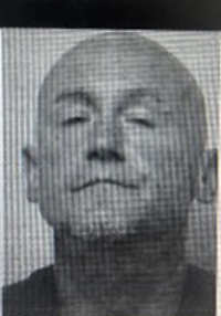
The second case is that of 43-year-old Matthew Vicchione.
Matthew Vicchione. Courtesy photo. Vicchione was last seen in the area of College Access Road and Dam Road Extension.
He is described as a white male adult, 5 feet 9 inches tall and 160 pounds. He is bald with brown eyes.
Vicchione was last seen wearing a black jacket, blue jeans and tan boots.
If anyone has any information on George's whereabouts, please contact the Clearlake Police Department at 707-994-8251, Extension 1.
State officials reported that, as part of an enhanced focus in 2025 to combat the scourge of illegal fentanyl trafficking, in January and February the California National Guard seized 1,045 pounds and more than 650,000 pills containing fentanyl, with a street valuation of more than $6.8 million.
Through their Counter Drug Task Force operations, the Cal Guard Task Force members have been strategically deployed statewide, including at ports of entry, to combat transnational criminal organizations and trafficking illegal narcotics like fentanyl, in support of federal, state, and local law enforcement partners.
“By disrupting the trafficking of the 1,045 pounds of fentanyl so far this year, Cal Guard’s Counter Drug Task Force continues to save countless lives across our state. I cannot thank them enough for their support in keeping deadly fentanyl out of our communities,” said Gov. Gavin Newsom.
Service members helped confiscate 488 pounds of powder-laced fentanyl and 331,069 pills of this dangerous drug in February, adding to the efforts in January.
In addition, Cal Guard service members continue to transform drug prevention in elementary, middle, and high schools statewide through the Task Force’s Drug Demand Reduction Outreach program.
Since October 2024, servicemembers visited 112 schools across the state and engaged with 57,442 students.
By conducting in-person outreach and understanding students’ beliefs about their own health using a Health Belief Model, Cal Guard is implementing an impactful initiative in the fight against opioid abuse.
Latest laboratory testing from the federal Drug Enforcement Agency indicates five out of 10 pills tested in 2024 contain a potentially deadly dose of fentanyl, which is down from seven of 10 pills in 2023.
Fentanyl is primarily smuggled into the country by U.S. citizens through ports of entry.
In 2024, Governor Newsom doubled down on the deployment of the Cal Guard’s Counterdrug Task Force by more than doubling the number of service members supporting fentanyl interdiction, and seizing other drugs, at California ports of entry to nearly 400.
Cal Guard’s coordinated drug interdiction efforts in the state are funded in part by California’s $60 million investment over four years to expand Cal Guard’s work to prevent drug trafficking by transnational criminal organizations.
This adds to the governor’s efforts to address fentanyl within California, including by cracking down on fentanyl in communities across the state, including San Francisco.
Addressing the opioid crisis
The state has launched various initiatives in recent years to combat illicit opioids through the Governor’s Master Plan for Tackling the Fentanyl and Opioid Crisis, which provides a comprehensive framework to support overdose prevention efforts, hold the opioid pharmaceutical industry accountable, crack down on drug trafficking, and raise awareness about the dangers of opioids like fentanyl.
Recently, through funding designated by the governor in the 2022-23 budget to develop the Fentanyl Enforcement Program, the Department of Justice announced a significant fentanyl bust worth $55 million and leading to the arrest of three major fentanyl traffickers.
The Campus Opioid Act, signed by Gov. Newsom in 2022, requires that every public college campus in California distribute a federally approved opioid overdose reversal medication like naloxone, and include information about opioid overdoses in their orientation process.
Last year, Newsom also signed AB 2429, requiring that fentanyl education be included in high school health classes starting in the 2026-27 school year.
Serving as a one-stop tool for Californians seeking resources for prevention and treatment, the website opioids.ca.gov provides information on how California is working to hold Big Pharma and drug traffickers accountable in this crisis.
The public education campaign Facts Fight Fentanyl informs Californians about the dangers of fentanyl and how to prevent overdoses and deaths. This effort will provide critical information about fentanyl and life-saving tools such as naloxone.
Through the Naloxone Distribution Project, over-the-counter CalRx-branded naloxone is now available across the state. The CalRx-branded over-the-counter naloxone HCL nasal spray, 4 mg, is available for free to eligible organizations through the state and for sale for $24 per twin-pack through Amneal. Since 2018, there have been over 334,000 reversals reported from NDP naloxone since 2018.

 How to resolve AdBlock issue?