How to resolve AdBlock issue?
Refresh this page
How to resolve AdBlock issue?
Refresh this page
Lake County News,California
  • Home
    • Registration Form
  • News
    • Education
    • Veterans
    • Community
      • Obituaries
      • Letters
      • Commentary
    • Police Logs
    • Business
    • Recreation
    • Health
    • Religion
    • Legals
    • Arts & Life
    • Regional
  • Calendar
  • Contact us
    • FAQs
    • Phones, E-Mail
    • Subscribe
  • Advertise Here
  • Login
How to resolve AdBlock issue?
Refresh this page

News

Middletown High heads to esports playoffs

Details
Written by: Elizabeth Larson
Published: 05 December 2024
Middletown High School Esports Team members Jimmy, Elliott and CJ with Coach Hall. Photo courtesy of Jennifer Pyzer.

LAKE COUNTY, Calif. — A team of Middletown High School students will compete Thursday evening in a West Coast playoff game in an esport competition.

Esports are multiplayer, organized video game competitions that can be viewed by spectators.

Jennifer Pyzer, Middletown High’s business and computer instructor, said the team competes in the High School Esport League and will play the game “APEX Legends.”

The competition includes East, Central and West regions. Middletown High will compete in the West Region, which consists of the Mountain, Pacific, Alaska and Hawaii time zone schools.

Middletown is small but proving mighty in the competition.

Pyzer said there were 36 schools competing in the APEX competition for the Fall Tournament.

“Middletown made it to the playoffs, and we are now in the semi-finals,” Pyzer said.

Pyzer said the top four teams are left.

Middletown’s record is 6-1; that’s the same record for Benjamin Franklin High School in the Los Angeles Unified School District, Pyzer said.

“We are ranked No. 2 and LAUSD Franklin is ranked No. 3,” Pyzer said.

Pyzer said the team will play in the semifinals at 5 p.m. Thursday, Dec. 5.

“There is a chance if they make it to the top rounds that they will be able to compete against the other regions — Central and East at a larger tournament in Texas,” Pyzer said.

Email Elizabeth Larson at This email address is being protected from spambots. You need JavaScript enabled to view it.. Follow her on Twitter, @ERLarson, and on Bluesky, @erlarson.bsky.social. Find Lake County News on the following platforms: Facebook, @LakeCoNews; X, @LakeCoNews; Threads, @lakeconews, and on Bluesky, @lakeconews.bsky.social.

Treppa Appointed to Federal Communications Commission’s Native Nations Communications Task Force

Details
Written by: LAKE COUNTY NEWS REPORTS
Published: 05 December 2024
UPPER LAKE, Calif. — The Federal Communications Commission has announced the appointment of Ambassador Sherry Treppa to its Native Nations Communications Task Force.

The task force is dedicated to addressing the broadband and communications infrastructure needs of tribal communities across the United States, with a focus on bridging the digital divide and enhancing connectivity for native nations.

“I am deeply honored to join the Native Nations Communications Task Force. This appointment ensures that Tribal voices, including ours, will be heard at the decision-making table. It is an opportunity to advocate for digital sovereignty and to ensure that Tribal Nations remain a key part of the conversation as we work to bridge the digital divide,” Treppa said.

Treppa, who served as chairperson of the Habematolel Pomo of Upper Lake for 16 years, brings extensive experience advocating for tribal sovereignty, economic self-reliance, and cultural preservation.

First elected in 2008, her leadership has been instrumental in fostering economic growth through innovative ventures.

Currently, she serves as ambassador for the tribe and as president of Habemco, the tribe’s fintech enterprise, which is a cornerstone of the Habematolel Pomo of Upper Lake’s economic development strategy.

In her role with the FCC, Treppa will help guide the agency’s efforts to address critical connectivity challenges facing tribal nations, ensuring that infrastructure investments and policy decisions reflect the unique needs of native communities.

Thompson, Padilla announce unanimous Senate vote to pass fire victims tax relief bill, send to president's desk

Details
Written by: LAKE COUNTY NEWS REPORTS
Published: 05 December 2024
On Wednesday, Rep. Mike Thompson (D-CA-04) and Sen. Alex Padilla (D-CA) announced the Senate’s unanimous vote to pass the bipartisan Federal Disaster Tax Relief Act (H.R. 5863).

The bill includes Rep. Thompson’s legislation that will exempt thousands of qualified wildfire victims in California from having to pay federal income tax on their settlement money or pay tax on attorney fees included in the settlement. This relief will also apply retroactively to qualified victims.

“Fire survivors have been through enough in the wake of losing their homes and livelihoods to wildfires — it’s wrong to tax them on the settlement money meant to help them rebuild their lives,” said Rep. Thompson on Wednesday. “The Senate’s unanimous vote to pass tax relief for fire survivors is an important step towards recovery for victims in my district and across California. Today’s overwhelming and bipartisan vote to deliver relief to victims was made possible by Senator Padilla and I thank him for his dedication and partnership in getting this passed.”

“Disaster settlement funds are not income, they’re compensation for what wildfire survivors have lost,” said Sen. Padilla. “When a wildfire survivor is combing through the ashes of their former home, the last thing they should have to worry about is how they’re going to pay taxes on any settlement they receive. Our bipartisan, bicameral bill will ensure the tens of thousands of Californians impacted by the Butte, North Bay, and Camp wildfires receive full and proper compensation to rebuild their lives after heartbreaking disaster.”

H.R. 5863 passed the Senate on Wednesday by unanimous consent. The bill will now go to President Biden’s desk to be signed into law.

Rep. Thompson serves as the Ranking Member of the Subcommittee on Tax for the Ways and Means Committee. He introduced the original legislation with Rep. Doug LaMalfa (CA-01) in the House of Representatives to provide tax relief to PG&E fire victims in the 117th Congress and has worked with Senator Padilla and Rep. LaMalfa to advance the legislation.

Earlier this year, Rep. Thompson and Rep. Greg Steube (FL-17) led a bipartisan group of 218 Members of Congress to successfully advance a discharge petition which forced House Speaker Mike Johnson to bring the Federal Disaster Tax Relief Act to the House floor for a vote. The historic advancement of Rep. Thompson and Rep. Steube’s petition marked only the third time a House discharge petition had succeeded in the 21st Century.

The Federal Disaster Tax Relief Act excludes from taxpayer gross income, for income tax purposes, any amount received by an individual taxpayer as compensation for expenses or losses incurred due to a qualified wildfire disaster (a disaster declared after 2014 as a result of a forest or range fire).

It also excludes relief payments for losses resulting from the East Palestine, Ohio, train derailment on Feb. 3, 2023 and designates Hurricane Ian, among other federally declared disasters, as a qualified disaster for the purposes of determining the tax treatment of certain disaster-related personal casualty losses.

More climate-warming methane leaks into the atmosphere than ever gets reported – here’s how satellites can find the leaks and avoid wasting a valuable resource

Details
Written by: Riley Duren, University of Arizona
Published: 05 December 2024


Far more methane, a potent greenhouse gas, is being released from landfills and oil and gas operations around the world than governments realized, recent airborne and satellite surveys show. That’s a problem for the climate as well as human health. It’s also why the U.S. government has been tightening regulations on methane leaks and wasteful venting, most recently from oil and gas wells on public lands.

The good news is that many of those leaks can be fixed – if they’re spotted quickly.

Riley Duren, a research scientist at the University of Arizona and former NASA engineer and scientist, leads Carbon Mapper, a nonprofit that is planning a constellation of methane-monitoring satellites. Its first satellite, a partnership with NASA’s Jet Propulsion Laboratory and the Earth-imaging company Planet Labs, launches in 2024.

Duren explained how new satellites are changing companies’ and governments’ ability to find and stop methane leaks and avoid wasting a valuable product.
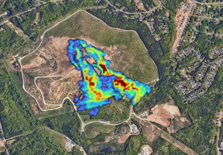
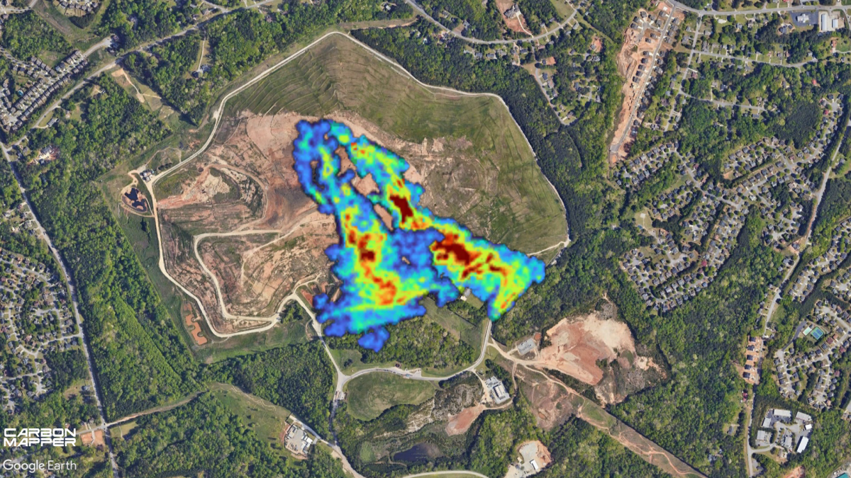
Colored areas show where methane is detected from a landfill surrounded by homes.
Methane plumes detected by plane at a Georgia landfill surrounded by homes. Carbon Mapper

Why are methane emissions such a concern?

Methane is the second-most common global-warming pollutant after carbon dioxide. It doesn’t stay in the atmosphere as long – only about a decade compared to centuries for carbon dioxide – but it packs an outsized punch.

Methane’s ability to warm the planet is nearly 30 times greater than carbon dioxide’s over 100 years, and more than 80 times over 20 years. You can think of methane as being a very effective blanket that traps heat in the atmosphere, warming the planet.

What worries many communities is that methane is also a health problem. It is a precursor to ozone, which can worsen asthma, bronchitis and other lung problems. And in some cases, methane emissions are accompanied by other harmful pollutants, like benzene, a carcinogen.
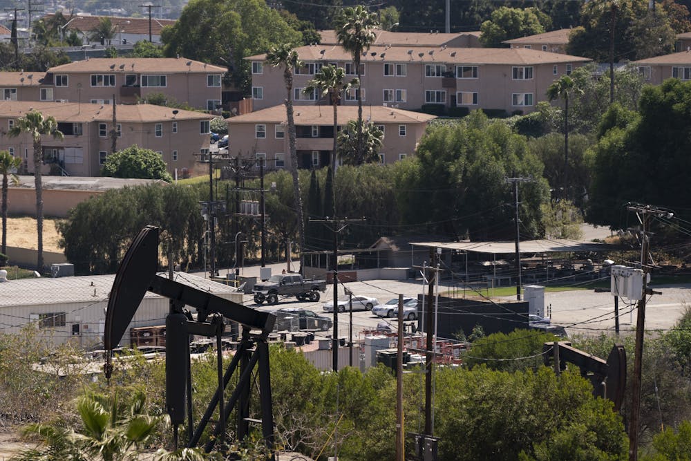
An oil pump across the street from apartment buildings in Los Angeles.
Los Angeles voted in 2022 to ban new oil wells and phase out existing ones. AP Photo/Jae C. Hong

In many oil and gas fields, less than 80% of gas that comes out of the ground from a well is methane – the rest can be hazardous air pollutants that you wouldn’t want anywhere near your home or school. Yet until recently, there was very little direct monitoring to find leaks and stop them.

Why are satellites necessary for catching methane leaks?

In its natural form, methane is invisible and odorless. You probably wouldn’t know there was a massive methane plume next door if you didn’t have special instruments to detect it.

Companies have traditionally accounted for methane emissions using a 19th-century method called an inventory. Inventories calculate emissions based on reported production at oil and gas wells or the amount of trash going into a landfill, where organic waste generates methane as it decomposes. There is a lot of room for error in this assumption-based accounting; for example, it does not account for unknown leaks or persistent venting.

Until recently, the state of the art in leak detection from oil and gas operations involved a technician paying a visit to a well pad every 90 days or so with a handheld infrared camera or gas analyzer. But a large leak can release a massive amount of gas over a period of several days and weeks or may occur in locations not readily accessible, meaning many of these so-called super-emitters go undetected.
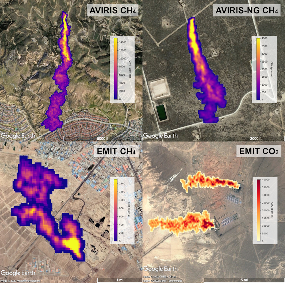
Satellite images show how methane plumes spread from different sources.
Methane plumes captured by NASA-designed airborne instruments (AVIRIS) and the EMIT instrument attached to the International Space Station. Clockwise from the top left: plumes from the Aliso Canyon storage blowout near Los Angeles in 2015, an oil and gas source in the Permian Basin, a power plant, and a landfill in Iran. NASA

Remote sensing satellites and airplanes, on the other hand, can quickly survey large areas routinely. Some of the newer satellites, including the ones we’re launching through the Carbon Mapper Coalition, can zoom in to individual sites at high resolution, so we can pinpoint methane super-emitters to the specific well pad, compressor station or section of a landfill.

You can see an example of the power of remote sensing in our recent paper in the journal Science. We surveyed 20% of the open landfills in the U.S. with airplanes and found that emissions on average were 40% higher than the emissions reported to the federal government using assumption-based accounting.
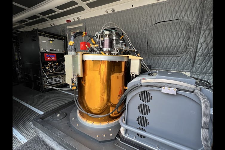
A large round instrument the size of an oil drum inside an airplane with padded walls
The copper-colored instrument is a spectrometer used by Carbon Mapper for airborne surveys of U.S. landfills. Arizona State University

If scientists can monitor regions frequently and consistently from satellites, then they can flag super-emitter activity and notify the operator quickly so the operator can find the problem while it’s still happening and fix any leaks.

How do satellites detect methane from space?

Most satellites capable of methane detection use some form of spectroscopy.

A typical camera sees the world in three colors – red, green and blue. The imaging spectrometers we use were developed by NASA’s Jet Propulsion Laboratory and see the world in almost 500 colors, including wavelengths beyond the visible spectrum into infrared, which is essential for detecting and measuring greenhouse gases.

Greenhouse gases like methane and carbon dioxide absorb heat in the infrared wavelengths – each with unique fingerprints. Our technology analyzes sunlight reflected from the Earth’s surface to detect those infrared fingerprints of methane and carbon dioxide in the atmosphere.

These signatures are distinct from all other gases, so we can image plumes of methane and carbon dioxide to determine the origins of individual super-emitters. Once we use spectroscopy to measure the amount of gas in a given plume, we can calculate an emission rate using wind speed data.

How methane emissions create health and climate problems. PBS.

What can the new satellites Carbon Mapper plans to launch do that others haven’t yet?

Each satellite has different and often complementary capabilities. MethaneSat, which the Environmental Defense Fund just launched in March 2024, is like a wide-angle lens that will produce a very precise and complete picture of methane emissions across large landscapes. Our Carbon Mapper Coalition satellites will complement MethaneSAT by acting like a collection of telephoto lenses – we’ll be able to zoom in to pinpoint individual methane emitters, like zooming in on a bird nesting in a tree.

Working with our partners at Planet Labs and NASA, we plan to launch the first Carbon Mapper Coalition satellite in 2024, with a goal of expanding the constellation in coming years to ultimately provide daily methane monitoring of high-priority regions around the world. For example, about 90% of the methane emissions from fossil-fuel production and use is estimated to come from only 10% of the Earth’s surface. So, we plan to focus Carbon Mapper Coalition satellites on oil, gas and coal production basins; major urban areas with refineries, wastewater plants and landfills; and major agriculture regions.

How will your monitoring data be used?

We expect from experience sharing our aircraft data with facility operators and regulators that a lot of our future satellite data will be used to guide leak detection and repair efforts.

Many oil and gas companies, landfill operators and some large farms with methane digesters are motivated to find leaks because methane in those cases is valuable and can be captured and put to use. So in addition to climate and health impacts, methane leaks are equivalent to venting profits into the atmosphere.

With routine satellite monitoring, we can quickly notify facility owners and operators so they can diagnose and fix any problems, and we can continue to monitor the sites to verify that leaks stay fixed.

Our data can also help to warn nearby communities of risks, educate the public, and guide enforcement efforts in cases where companies aren’t voluntarily fixing their leaks. By measuring trends in high-emission methane events over time and across basins, we can also contribute to assessments about whether policies are having their intended effect.The Conversation

Riley Duren, Research Scientist, University of Arizona

This article is republished from The Conversation under a Creative Commons license. Read the original article.

  1. Police arrest suspect in Clearlake murder
  2. Lake County’s election results finalized; Owen tops Hess for District 1 race
  3. Health officials report on success in tobacco prevention policy milestones
  • 523
  • 524
  • 525
  • 526
  • 527
  • 528
  • 529
  • 530
  • 531
  • 532
How to resolve AdBlock issue?
Refresh this page