 How to resolve AdBlock issue?
News
- Details
- Written by: Lake County News reports
The sea level off most of California is expected to rise about one meter over the next century, an amount slightly higher than projected for global sea levels, and will likely increase damage to the state’s coast from storm surges and high waves, says a new report from the National Research Council.
Sea levels off Washington, Oregon and Northern California will likely rise less, about 60 centimeters over the same period of time, according to the report.
However, the report said an earthquake magnitude 8 or larger in this region could cause sea level to rise suddenly by an additional meter or more.
Global sea level rose during the 20th century, and projections suggest it will rise at a higher rate during the 21st century.
A warming climate causes sea level to rise primarily by warming the oceans – which causes the water to expand – and melting land ice, which transfers water to the ocean.
However, sea-level rise is uneven and varies from place to place. Along the U.S. West Coast it depends on the global mean sea-level rise and regional factors, such as ocean and atmospheric circulation patterns, melting of modern and ancient ice sheets, and tectonic plate movements.
California Executive Order S-13-08 directed state agencies to plan for sea-level rise and coastal impacts and asked the Research Council to establish a committee to assess sea-level rise. Oregon, Washington, and several federal agencies joined California to sponsor the study.
The report estimates sea-level rise both globally and for those three states for the years 2030, 2050 and 2100.
The committee that wrote the report projected that global sea level will rise 8 to 23 centimeters by 2030, relative to the 2000 level, 18 to 48 centimeters by 2050, and 50 to 140 centimeters by 2100.
The 2100 estimate is substantially higher than the United Nation’s Intergovernmental Panel on Climate Change’s projection made in 2007 of 18 to 59 centimeters with a possible additional 17 centimeters if rapid changes in ice flow are included.
For the California coast south of Cape Mendocino, the committee projected that sea level will rise 4 to 30 centimeters by 2030, 12 to 61 centimeters by 2050, and 42 to 167 centimeters by 2100.
For the Washington, Oregon, and California coast north of Cape Mendocino, sea level is projected to change between falling 4 centimeters to rising 23 centimeters by 2030, falling 3 centimeters to rising 48 centimeters by 2050, and rising between 10 to 143 centimeters by 2100.
The committee noted that as the projection period lengthens, uncertainties, and thus ranges, increase.
The committee’s projections for the California coast south of Cape Mendocino are slightly higher than its global projections because much of the coastline is subsiding.
The lower sea levels projected for northern California, Washington and Oregon coasts are because the land is rising largely due to plate tectonics.
In this region, the ocean plate is descending below the continental plate at the Cascadia Subduction Zone, pushing up the coast.
Extreme events could raise sea level much faster than the rates projected by the committee.
For example, an earthquake magnitude 8 or greater north of Cape Mendocino, which occurs in this area every several hundred to 1,000 years with the most recent in 1700, could cause parts of the coast to subside immediately and the relative sea level to rise suddenly by a meter or more.
“As the average sea level rises, the number and duration of extreme storm surges and high waves are expected to escalate, and this increases the risk of flooding, coastal erosion, and wetland loss,” said Robert Dalrymple, committee chair and Willard and Lillian Hackerman Professor of Civil Engineering at Johns Hopkins University.
Most of the damage along the west coast is caused by storms, particularly the confluence of large waves, storm surges, and high tides during El Niño events.
Significant development along the coast – such as airports, naval air stations, freeways, sports stadiums, and housing developments – has been built only a few feet above the highest tides. For example, the San Francisco International Airport could flood with as little as 40 centimeters of sea-level rise, a value that could be reached in several decades.
The committee also ran a simulation that suggested sea-level rise could cause the incidence of extreme water heights in the San Francisco Bay area to increase from about 9 hours per decade, to hundreds of hours per decade by 2050, and to several thousand hours per decade by 2100.
The study was sponsored by the states of California, Washington and Oregon; National Oceanic and Atmospheric Administration; U.S. Geological Survey; and U.S. Army Corps of Engineers.
The National Academy of Sciences, National Academy of Engineering, Institute of Medicine, and National Research Council make up the National Academies. They are independent, nonprofit institutions that provide science, technology, and health policy advice under an 1863 congressional charter.
Panel members, who serve pro bono as volunteers, are chosen by the academies for each study based on their expertise and experience and must satisfy the academies’ conflict-of-interest standards.
The resulting consensus reports undergo external peer review before completion.
For more information, visit http://national-academies.org/studycommitteprocess.pdf .
- Details
- Written by: Dr. Tony Phillips
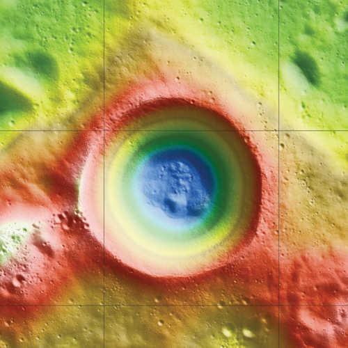
According to data from NASA's Lunar Reconnaissance Orbiter (LRO), ice may make up as much as 22 percent of the surface material in Shackleton Crater at the Moon's south pole.
The huge crater, named after the Antarctic explorer Ernest Shackleton, is two miles deep and more than 12 miles wide.
The small tilt of the lunar spin axis means Shackleton's interior is permanently dark and very cold. Researchers have long thought that ice might collect there.
When a team of NASA and university scientists used LRO's laser altimeter to examine the floor of Shackleton crater, they found it to be brighter than the floors of other nearby craters around the South Pole.
This is consistent with the presence of small amounts of reflective ice preserved by cold and darkness. The findings are published in today's edition of the journal Nature.
In addition to the possible evidence of ice, the group's map of Shackleton revealed a remarkably preserved crater that has remained relatively unscathed since its formation more than three billion years ago.
The crater's floor is itself pocked with several small craters, which may have formed as part of the collision that created Shackleton.
"The crater's interior is extremely rugged," said Maria Zuber, the team's lead investigator from the Massachusetts Institute of Technology in Cambridge in Mass. "It would not be easy to crawl around in there."
While the crater's floor was relatively bright, Zuber and her colleagues observed that its walls were even brighter.
The finding was at first puzzling. Scientists had thought that if ice were anywhere in a crater, it would be on the floor, where no direct sunlight penetrates. The upper walls of Shackleton Crater are occasionally illuminated, which could evaporate any ice that accumulates.
"The brightness measurements have been puzzling us since two summers ago," said Gregory Neumann of NASA's Goddard Space Flight Center in Greenbelt, Md., a co-author on the paper.
A theory offered by the team to explain the puzzle is that "moonquakes" – seismic shaking brought on by meteorite impacts or gravitational tides from Earth – may have caused Shackleton's walls to slough off older, darker soil, revealing newer, brighter soil underneath.
Zuber's team's ultra-high-resolution map provides strong evidence for ice on both the crater's floor and walls.
"There may be multiple explanations for the observed brightness throughout the crater," said Zuber. "For example, newer material may be exposed along its walls, while ice may be mixed in with its floor."
For more information on LRO and the Lunar Orbiter Laser Altimeter, visit http://lunar.gsfc.nasa.gov .
Dr. Tony Phillips works for the National Aeronautics and Space Administration.
- Details
- Written by: Elizabeth Larson
THIS STORY HAS BEEN UPDATED WITH THE CONDITION OF THE MOTORCYCLIST.
CLEARLAKE, Calif. – A motorcyclist had his leg broken and had to be flown to an out-of-county trauma center following a late Thursday night crash in Clearlake.
Edward Montellier, 28, suffered a compound fracture to his leg after his motorcycle was hit by a pickup just before 11:30 p.m. Thursday, according to police.
Clearlake Police Sgt. Tim Hobbs said Montellier was riding his motorcycle eastbound on Arrowhead Road approaching Fresno Street.
Tyler Gillam, 19, also of Clearlake, was stopped at the Fresno and Arrowhead intersection in his 1996 GMC pickup, Hobbs said.
Gillam didn't see Montellier and pulled into Arrowhead, colliding with Montellier's motorcycle, according to Hobbs.
Radio reports late Thursday indicated a landing zone was set up at Austin Park, with REACH 1 air ambulance picking Montellier up from there shortly after midnight early Friday.
Hobbs said Montellier was transported to Queen of the Valley Medical Center in Napa, but later transported to UC Davis Medical Center in Sacramento.
UC Davis Medical Center confirmed to Lake County News that Montellier was at that hospital, but his condition status was not available mid-afternoon Friday, as he was still being assessed by a physician.
Later Friday evening the hospital reported Montellier was in fair condition.
Hobbs said Gillam was not cited for the crash.
Email Elizabeth Larson at
- Details
- Written by: Elizabeth Larson
CLEARLAKE, Calif. – A Clearlake man was injured early Thursday morning when he hit a portion of a culvert.
Orlando Franklin, 55, suffered moderate injuries in the crash, according to Sgt. Martin Snyder of the Clearlake Police Department.
Shortly before 2:30 a.m. Franklin was riding his bicycle and turning onto Risher Drive when he hit a portion of a culvert tube.
Franklin's front light may have been underpowered, causing him not to see the object, Snyder said.
When his bike hit the culvert tube Franklin was thrown over the handlebars and into a nearby ditch, according to Snyder.
Snyder said Franklin suffered severe facial injuries.
Radio reports indicated that Franklin was picked up by a REACH air ambulance at a landing zone at Ray's Food Place and flown to Santa Rosa Memorial Hospital.
Email Elizabeth Larson at