 How to resolve AdBlock issue?
News
- Details
- Written by: Elizabeth Larson

LAKE COUNTY, Calif. – Lake County’s Redbud Audubon Society is preparing to participate in the national Audubon Society’s 112th annual Christmas Bird Count.
The national Christmas Bird Count takes place this year between Wednesday, Dec. 14, and Thursday, Jan. 5.
Individual counts are held on specific days, and in Lake County, the 37th annual Clear Lake Christmas Bird Count, will take place on Saturday, Dec. 17.
Gary Langham, chief scientist for the National Audubon Society, calls the annual bird count “a globally recognized example of crowd-science.”
The National Audubon Society said the annual bird counts collect data important to the long-term health of North America’s diverse bird populations, and helps track how those populations have changed since the first bird count was held.
“Data from Audubon’s Christmas Bird Count are at the heart of hundreds peer-reviewed scientific studies,” Langham said. “CBC data have informed the U.S. State of the Birds Report, issued by the Department of the Interior, and modeled after Audubon’s annual reports begun in 2004. For example, in 2009, CBC analyses revealed the dramatic impact climate change is already having on birds across the continent."
The inspiration for the first count in 1900 came from Frank Chapman, founder of “Bird-Lore” – today’s “Audubon” magazine – who suggested that people hunt birds only to count them. The National Audubon Society said Chapman’s proposal was an alternative to “side hunts” in which teams of hunters competed to shoot the most animals and birds.
The 2010 national bird count included a record 2,215 counts from all 50 states, all Canadian provinces and 107 count circles in Latin America, the Caribbean and the Pacific Islands, the National Audubon Society reported. Approximately 62,624 people tallied more than 60 million birds.
“Everyone who takes part in the Christmas Bird Count plays a critical role in helping us focus attention and conservation where it is most needed.” said Audubon Christmas Bird Count Director Geoff LeBaron.
LeBaron said the work is the foundation of Audubon’s “WatchList,” which identifies species in need of conservation help.
The national organization said the count also helps spotlight success stories, such as the comeback of the bald eagle and increases in other populations that have benefited from conservation.
In preparation for the local bird count, Redbud Audubon will hold a meeting to discuss bird identification on Thursday, Dec. 15, at 7:15 p.m. at the Kelseyville Presbyterian Church Social Hall, 5430 Third St.
Society member and photographer Brad Barnwell will lead a discussion on bird identification and characteristics of birds that count participants may see in the field.
Everyone from beginners to veteran birders are welcome to take part; beginners can learn from more experienced observers and experts during the count.
Each count group has a designated circle of 15 miles in diameter, according to the National Audubon Society.
First-time counters will be invited to participate in one of two count teams: the Anderson Marsh State Historic Park team led by Field Trips Leader Pat Harmon or the Clear Lake State Park team led by Barnwell.
Both groups start at 8 a.m. at either the Anderson Marsh parking lot or the Clear Lake State Park Visitor Center parking lot.
After the completion of the Clear Lake Christmas Bird Count on Dec. 17, participants are invited for a pizza dinner at Kelseyville Pizza at 6 p.m., where the group will compile the tally of birds sighted that day.
Anyone interested in participating in the bird count is asked to contact Darlene Hecomovich at 707-928-5591 or
E-mail Elizabeth Larson at
- Details
- Written by: Dr. Tony Phillips

NASA's Mars rover Opportunity has found bright veins of a mineral, apparently gypsum, deposited by water near the rim of Endeavour Crater.
The discovery was presented Wednesday, Dec. 7, at the American Geophysical Union's conference in San Francisco.
“This tells a slam-dunk story that water flowed through underground fractures in the rock,” said Steve Squyres of Cornell University, Ithaca, N.Y., principal investigator for Opportunity. “This stuff is a fairly pure chemical deposit that formed in place right where we see it.1 It's the kind of thing that makes geologists jump out of their chairs.”
The vein examined most closely by Opportunity is about the width of a human thumb (1 to 2 centimeters) and 40 to 50 centimeters long.
Observations by the rover reveal this vein and others like it within an apron surrounding the rim of Endeavour Crater.
Nothing like it was seen in the 33 kilometers of crater-pocked plains that Opportunity explored for 90 months before it reached Endeavour, nor in the higher ground of the crater's rim.
Last month, researchers used the Microscopic Imager and Alpha Particle X-ray Spectrometer on the rover's arm and multiple filters of the Panoramic Camera on the rover's mast to examine the vein, which is informally named "Homestake."
The spectrometer identified plentiful calcium and sulfur, in a ratio pointing to relatively pure calcium sulfate.
Calcium sulfate can exist in many forms varying by how much water is bound into the minerals' crystalline structure. The multi-filter data from the camera suggest gypsum, a hydrated calcium sulfate. On Earth, gypsum is used for making drywall and plaster of Paris.
Observations from orbit had detected gypsum on Mars previously. A dune field of windblown gypsum on far northern Mars resembles the glistening gypsum dunes in White Sands National Monument in New Mexico. The origin of that windblown gypsum is, however, uncertain.
"It is a mystery where gypsum sand on northern Mars comes from," said Opportunity science-team member Benton Clark of the Space Science Institute in Boulder, Colo. "At Homestake, however, we see the mineral right where it formed. It will be important to see if there are deposits like this in other areas of Mars."
The Homestake deposit, whether gypsum or another form of calcium sulfate, likely formed from water dissolving calcium out of volcanic rocks.
The calcium combined with sulfur that was either leached from the rocks or introduced as volcanic gas, and it was deposited as calcium sulfate into an underground fracture that later became exposed at the surface.
The discovery of gypsum fits the emerging picture of an ancient wet environment.
Throughout Opportunity's long traverse across Mars' Meridiani plain, the rover has driven over bedrock composed of magnesium, iron and calcium sulfate minerals that also indicate the presence of water billions of years ago.
The highly concentrated calcium sulfate at Homestake could have been produced in conditions more neutral than the harshly acidic conditions indicated by the other sulfate deposits observed by Opportunity.
"It could have formed in a different type of water environment, one more hospitable for a larger variety of living organisms," Clark said.
Opportunity has been exploring Mars for nearly eight years, far exceeding than the rover's original 3-month mission, which began in 2004.
Gypsum veins are just the latest example of an important discovery about wet environments on ancient Mars that may have been favorable for supporting microbial life.
Opportunity's equally productive twin, Spirit, stopped communicating in 2010. Opportunity continues exploring, currently heading to a sun-facing slope on the northern end of the Endeavour rim fragment called "Cape York" to keep its solar panels at a favorable angle during the mission's fifth Martian winter.
For more information about the rovers, including NASA's newest rover Curiosity now en route to Mars, visit http://www.nasa.gov/rovers and http://marsrovers.jpl.nasa.gov.
Dr. Tony Phillips works for the National Aeronautics and Space Administration.
Follow Lake County News on Twitter at http://twitter.com/LakeCoNews, on Tumblr at www.lakeconews.tumblr.com, on Google+, on Facebook at www.facebook.com/pages/Lake-County-News/143156775604?ref=mf and on YouTube at www.youtube.com/user/LakeCoNews .

- Details
- Written by: Lake County News reports
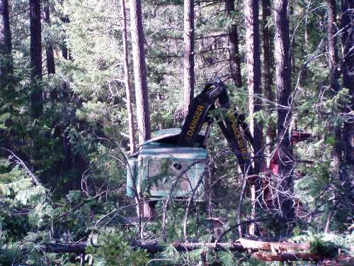
California’s landscapes are under siege from a host of threats – catastrophic wildfire, climate change, invasive species and increasing human population put these delicate ecosystems at risk.
The U.S. Forest Service has recognized and battled these threats for decades, but recently the agency recognized the need for a more focused approach on ecological restoration as the primary goal for all land management actions.
The goal is to retain and restore ecological resilience of the National Forest lands to achieve sustainable ecosystems that provide a broad range of services and value.
Ecologically healthy and resilient landscapes, rich in biodiversity, have greater capacity to adapt and thrive in the face of natural disturbances and large scale threats.
The Forest Service recognizes that it cannot achieve its goals alone.
“The emphasis will be placed on expanding and developing partnerships to increase organizational capacity and the use of large-scale stewardship contracts operating at the landscape level to achieve restoration goals,” said Pacific Southwest Regional Forester Randy Moore.
In Northern California, the Eldorado and Mendocino National Forests and the Lake Tahoe Basin have been working hard on various Ecological Restoration projects.
On the Eldorado National Forest, restoration activities continued this year in the Bassi Falls-Millionaire Camp area on the Pacific Ranger District.
In the past, vehicles drove across a web of user-created roads both on public and private lands to access Bassi Falls.
In 2002, the Pacific Ranger District coordinated with the adjacent land owner, Sierra Pacific Industries, to improve watershed conditions by closing user-created roads, blocking access and replanting denuded areas.
A nonmotorized hiking trail was constructed to allow access to Bassi Falls and a parking area was identified in the Millionaire Camp for access to a popular dispersed camping area along Big Silver Creek.
Shortly after the original restoration project, the private land in the area was acquired by the Forest Service through the Silver-Pearl land exchange.
Restoration efforts on this project have continued over the past several years with a focus on improving conditions on those lands acquired through the land exchange.
There are several areas where large amounts of soil have eroded away from motorized vehicle impacts, and are still eroding despite the removal of motorized vehicles. In addition, much of the hiking trail, which is made up of old user-created roads have poor drainage and erosion issues.
Current restoration activities include repairing hillsides that have old roads that are currently causing problems in various streams and rivers.
The work includes a variety of activities primarily to prevent water running down the middle of roads. In some cases, small dams will be constructed to catch sediment before it gets to streams and rivers.
Water quality problems will be resolved by removing some dirt roads and returning the hillside to a more natural state.
To do this, some roads will be plowed with heavy equipment so trees and other vegetation will grow where the road was located. We will also repair some streams in meadows that are eroding along the streamsides.
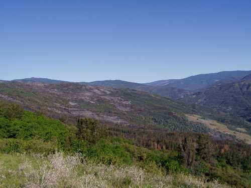
The Mendocino National Forest has a variety of ecological restoration projects, including marijuana site restoration and fuels reduction.
Illegal marijuana cultivation not only poses a risk to public and employee safety, it also directly harms the environment.
The illegal use of pesticides can cause extensive long-term damage to natural resources. For example, the supply of public drinking water for hundreds of miles may be impacted due to one marijuana growing site.
Overall, the negative impact of marijuana sites on natural resources is severe. Human waste and trash are widespread, contamination from sites affects fish and wildlife habitats, and soil erosion is common.
In addition, water usage is extreme because each marijuana plant is estimated to require a gallon of water per day – water that is critical to native vegetation, wildlife and public drinking water sources.
“Reclaiming sites damaged by illegal marijuana cultivation is an important part of Ecological Restoration efforts,” said Mendocino National Forest Supervisor Lee Johnson. “All resources are touched by this activity – water, soils, wildlife and the overall health of the forest. Restoration efforts help not only the forest resources, but also benefit the public that uses the National Forest System lands for recreation, as well as for clean water and clean air.”
Another Ecological Restoration project on the Mendocino National Forest is the Alder Springs Fuel Reduction Project which was begun to thin the dense second-growth conifer stand that developed after a fire in the 1920s.
The intent was to improve forest health and reduce the risk of a stand-replacing fire in the future.
The Alder Springs project also included prescribed burning of adjacent non-conifer vegetation to expand the fuels reduction work and to maintain fire processes.
A carbon budget study was integrated into project implementation in partnership with Wheelabrator and Winrock International.
“The Alder Springs Project is an example of how Ecological Restoration has been essential to managing the resources on the Mendocino National Forest,” said Johnson. “Ecological Restoration on the Forest includes an integrated approach across all resources, utilizing opportunities on a broader landscape for better results, working with partners, finding opportunities for research for further understanding and development, and continuing the project through maintenance and developing a unified vision for future management.”
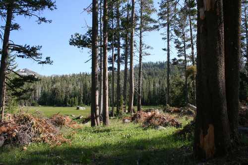
The Lake Tahoe Basin Management Unit recently completed the latest phase of tree thinning aimed at restoring the health of meadows, aspen groves and forest uplands near Big Meadow Creek.
Contract crews worked to thin conifers on 55 acres surrounding the popular Scotts Lake Trail, off Big Meadow Trailhead near Luther Pass on Highway 89.
In all, the Forest Service expects to treat about 640 acres, piling the material to burn later.
The tree-thinning is part of a larger project, the Big Meadow Creek Watershed Fire Regime Restoration, which will continue for several years.
Prior to the recent practice of actively suppressing fires, ground fires occurred naturally. The Washoe Tribe also deliberately used fire to encourage the growth of desired plant and tree species, such as willow and aspen, and attract the wildlife that depend on this vegetation. Without periodic fires that destroy conifer seedlings, the trees overtake aspen stands and meadows and can lead to forest die-off from insect infestation, drought or fire.
Once the initial thinning and pile burning are complete, the Forest Service will begin meadow burns that more closely simulate the natural role fire once played in the ecosystem.
“Thinning trees reduces competition for water, nutrients and sunlight, which helps meadow vegetation and aspens thrive and allows the remaining trees in forested area to grow larger,” said Forest Supervisor Nancy Gibson. “This work, funded through the Southern Nevada Public Land Management Act, will help to restore the Big Meadow ecosystem, providing important wildlife habitat and preserving one of our special places in the Lake Tahoe Basin.”
“Ecological Restoration crosses land boundaries and includes many different projects,” said Moore. “Ultimately we want to create landscapes that survive and thrive in a changing environment and provide goods, services and recreation opportunities now and for generations to come.”
Follow Lake County News on Twitter at http://twitter.com/LakeCoNews, on Tumblr at www.lakeconews.tumblr.com, on Google+, on Facebook at www.facebook.com/pages/Lake-County-News/143156775604?ref=mf and on YouTube at www.youtube.com/user/LakeCoNews .
- Details
- Written by: Lake County News reports
The AccuWeather.com Long-Range Forecasting Team reported that while the worst of winter will be focused over the Midwest and Northwest, it does not mean other parts of the country are off the hook.
A weak to moderate La Niña is a key factor in the 2011-2012 Winter Forecast with more typical La Nina winter conditions expected.
"La Niña, a phenomenon that occurs when sea surface temperatures across the equatorial central and eastern Pacific are below normal, is what made last year's winter so awful for the Midwest and Northeast," AccuWeather.com Meteorologist Heather Buchman stated in the initial release of the 2011-2012 Winter Forecast.
La Niña winters feature a stronger Northern jet stream, an area of strong winds high above the Earth's surface. This positioning and strength of the jet stream tends to cause storms to track across the northern tier, spelling harsh winters from the Northern Plains to the Ohio Valley.
Typically, the southern tier of the U.S. ends up mild and dry in a La Niña winter. There will be some exceptions to that this year with wet weather anticipated for parts of the Lower Mississippi Valley.
Another big factor in the winter forecast is the potential for a blocking pattern to develop with the NAO, or North Atlantic Oscillation, possibly turning negative for a time. This essentially means that a large area of high pressure could set up over Greenland, forcing cold blasts to reach the U.S.
"The lack of sea ice has been believed to contribute to the development of blocking. This past summer and early fall, sea ice reached near-record low levels," according to the National Snow and Ice Data Center.
Paul Pastelok and the Long-Range Forecasting Team that he leads still think Old Man Winter will leave the biggest impression on the northern Rockies, northern Plains and the Midwest.
It will be a snowier-than-usual season for the Midwest, which will lie to the north and west of the frequent storm track, or in the "sweet spot" of the storms.
Typical of a La Niña year, the harshest cold will blast the northern Plains and northern Rockies.
Winter looking wetter for California, still stormy for Northwest
The 2011-2012 Winter Forecast was updated to show even more rain and snow for northern and central California with the Pacific jet stream expected to hover over this area for most of the winter season.
Farther inland, this winter is expected to be another active one for the northern Sierra and interior Northwest with above-normal snowfall forecast.
In contrast, the Pacific Northwest, including much of Washington and western Oregon, will get some breaks from the wet weather.
"Watch for a 'Pineapple Connection' during the mid- to late season that will send some areas well above-normal precipitation," Pastelok said. This means "snow in the mountains and rain and mudslides in the valleys."
Also known as the "Pineapple Express," the Pineapple Connection is a phenomenon that occurs when a strong, persistent flow of tropical moisture sets up from the Hawaiian islands to the West Coast of the U.S. This phenomenon often leads to excessive rain and incredible snow events.
Follow Lake County News on Twitter at http://twitter.com/LakeCoNews, on Tumblr at www.lakeconews.tumblr.com, on Google+, on Facebook at www.facebook.com/pages/Lake-County-News/143156775604?ref=mf and on YouTube at www.youtube.com/user/LakeCoNews .