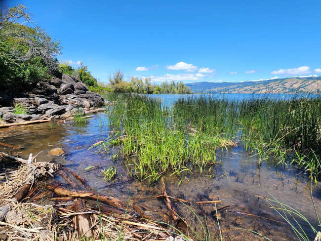
Natural shoreline plant communities prevent erosion, cycle nutrients, improve water quality and create complex habitat structures which support aquatic, amphibian, and terrestrial wildlife populations. Courtesy photo. Dear Lady of the Lake,
I heard that Clear Lake has lost wetland shorelines needed to help improve the water quality of the lake, which gets pretty green and concerning during the summer. We live on the lake, is there something we can do to help the lake and the shorelines?
- Barb and Gary in Glenhaven
Dear Barb and Gary,
Thanks for this question! This is a great topic to discuss right now as the lake is clearly demonstrating what happens when a natural water body has too many nutrients and too little natural shoreline to help trap or use those nutrients - an abundance of cyanobacteria and algae blooms!
The good news is that together, as informed shoreline stewards, we have the power to make a change that will have some positive impacts on Clear Lake water quality.
First we will discuss the important role of shorelines in lakes, the state of shorelines in Clear Lake and the resources available to help shoreline property owners restore their lakeshore.
For background and reference information on structures and benefits of natural shorelines Please refer to my previous column, “Shorelines Sure are Something Special.”
Shorelines are the backbone of any lake, pond, stream, or coastal zone. They provide the structure around the water and act as a zone of transition between the land and the water. Shorelines are very unique in that they are not always dry or aquatic, but some variable combination of the two at any time.
The zone of shallow water that connects the shoreline to the open water of a lake is called the littoral zone, and this includes the edge of the shoreline area that touches water, and shallow portion of the lake before the slope gets too deep and the water gets too dark that plants can’t or don’t grow. The deep, open water zone of the lake is called the pelagic zone.
In Clear Lake, because the majority of the lake is a shallow basin or bordered by shallow-sloped shorelines and the lake water level can go from very full to very low within a couple years, the shoreline around the lake and the littoral zone share a lot of the same physical space and features. Sometimes the shoreline zone is inundated with water and sometimes it’s not.
When you consider this variability, you realize that shorelines truly are special. They provide habitat for a unique and specific range of organisms, flora, and fauna. When shorelines are removed, converted, or become degraded, we can see significant species and biodiversity loss because of the specific niche habitat the shoreline provides.
Not all plant species can tolerate, let alone thrive, in the littoral or shoreline zone. Examples of plants that have adapted to shoreline life and are prolific here in Clear Lake are Tules, technically known as Hard Stem Bulrush (Schoenoplectus acutus), native aquatic smartweed (Polygonum amphibium) and a variety of native willows (Salix sp.).
There are some invasive species such as invasive creeping water primrose (Ludwigia peploides) that grow aggressively along shorelines and into the littoral zone. Primrose can become a significant nuisance to boaters, swimmers, fish and wildlife. Refer to my column “Peeved about Primrose.”
What are natural shorelines?
A natural shoreline with a rich native plant community is essential to the proper form and function of any lake littoral zone. Like the shoreline zone, the littoral zone is also usually vegetated and provides a safe refuge for small and juvenile fish and amphibians, structural habitat complexity provides essential food web components, such as plants, insects, and green algae (i.e. phytoplankton).
Natural shorelines can reduce erosion and bioturbation of shoreline sediments, which prevents nutrients (like phosphorus sourced from the sediment) from mobilizing from the shorezone into the open water. This is really important because the cyanobacteria blooms that grow to health hazard conditions in our lake use nutrients as a needed food source.
If there are more nutrients in the water column, combined with summer warmth and sunshine, the cyanobacteria can basically keep growing, indefinitely. Some cyanobacteria have the ability to produce toxins which can be dangerous to people, pets and wildlife.
Because shorelines are full of life, they can also contain some death, and this process, especially in natural lakes can be very smelly. If you live on the lake I am sure you have experienced a striking array of noticeable notes for your nostril at least once or twice. I explore those particularly distinctive odors and sources in my column, “What’s that smell?”
Natural shorelines, with a rich, diverse native plant community can improve lake water quality because plants compete with cyanobacteria and algae for nutrients and space. When plants go dormant in fall, they break down and decompose into the sediments, trapping the nutrients they removed from the water column, into the lake sediments where they can be stored until next year’s plants use them when they sprout and grow.
However, some valuable native species are declining as a direct result of shoreline degradation and loss. For example the Clear Lake Hitch, an endemic minnow species found only in Clear Lake, has been declining in population for decades. Hitch are rather small fish, and as juveniles, after they swim down from the streams where they are born, they live their first year of life within the shoreline and littoral lake zones.
Natural shoreline and wetland loss around Clear Lake is a strongly recognized factor contributing to hitch population declines, which makes sense when we look at the amount of natural shoreline loss that has occurred around the lake due to development, roads, sea wall construction, and wetland conversion.
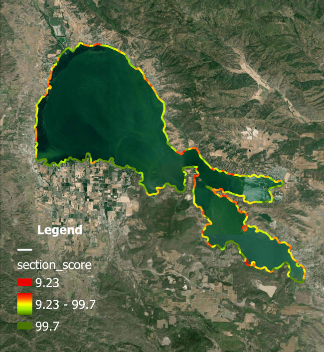
In 2020-2022 the Lake County Water Resources Department conducted a boat-based shoreline survey around Clear Lake. This survey was modified from a program created by the Michigan Clean Water Corps (MiCorps) called “Score the Shore”.
For more information on this program and to access data, visit the County of Lake Water Resources Shoreline Stewardship website.
Just like the name sounds, this survey makes it possible for researchers and managers to “score” a shoreline based on a combination of quantitative and qualitative, or normally subjective features.
The survey was conducted in 1000 ft sections and staff, with help from AmeriCorp Civic Spark Fellows, made several shore-parallel passes back and forth at each 1000 ft section. During these passes, physical features along the shoreline were counted or noted in the digital survey form: docks, sea walls, ramps, other hardscaping such as boulders, rip rap, vertical walls or structures, percentage of natural vegetation like trees, shrubs or tules, in-water structures like woody debris, open space, and others.
All of these features, some weighted differently than others, were entered into a program that calculated a score that was transformed to a scale of 0 - 100, with 100 being the most perfect and healthy natural shoreline possible and 0 being the most degraded shoreline void of any natural features or benefits.
The data and visual results of this survey makes shoreline restoration planning possible for Clear Lake managers, especially when prioritizing very expensive and time-consuming shoreline restoration projects or mitigation strategies for in-lake water quality improvement.
Visual results of the Lake County Water Resources Score the Shore survey conducted between 2021 and 2022. The best natural shoreline is scored at 99.7 (green), and the worst shoreline is scored at 9.23 (red). Survey methodology was developed and shared by Michigan Clean Water Corps Score the Shore Program (https://www.micorps.net/). Used with permission. While there are a lot of green, or healthy regions of natural shoreline, around the lake, note that there is an abundant amount of orange, yellow, and red too. Yellow and orange indicate fair and poor shoreline quality, the equivalent to a C and D grade, if our shoreline was still in school.
Speaking of school, here is a quiz question for you at home:
When you think about areas around the lake that tend to have heavy or recurring blooms throughout the growing season, do they seem to occur in places around or near areas of shoreline that were scored yellow, orange, or red on the Score the Shore map?
What about comparing the three arms of the lake, between the Upper Arm, the Oaks Arm, and the Lower Arm, which arms tend to have more cyanobacteria-bloom trouble spots, and which arms appear to have more yellows, oranges, and red shoreline scores?
If you happened to indulge yourself in the above self-quiz, the Lady of the Lake would be very interested in your answers! You can send them to This email address is being protected from spambots. You need JavaScript enabled to view it.. Don’t worry, this won’t affect your final grade, it’s all extra credit, I assure you.
Lake managers at County of Lake Water Resources are very curious about these relationships too and are starting to work with aquatic analytical teams at Michigan State University Landscape Limnology Lab, Micorps, and the San Francisco Estuary Institute to dive into this research question and explore the relationships between shoreline development features, natural shorelines, lake water quality, and cyanobacteria bloom frequency and severity.
It's important to note that the Score the Shore result is derived from a descriptive process to assess shoreline quality. It is not a regulatory mechanism to enforce or limit what people can and can’t do on their shorelines. Chapter 23 of the Lake County Ordinances is the guideline, law and regulation for shoreline activities in Clear Lake.
However, information developed through the Score the Shore, and derived research results, can provide lake managers useful information to shape policy to improve lake conditions and protect shorelines. Future updates to Ch. 23 might reflect insights learned through the Score the Shore process, results and any resulting shoreline study effort.
The Score the Shore is also based on large 1000 ft long segments, so no one single property is being analyzed or scrutinized in any future studies. The goal of effective lake management is to target areas that would have the most high-impact restoration potential, and that extends beyond just a single parcel or property on the lake.
Clear Lake is not alone in having experienced some form of shoreline degradation. According to the US EPA National Lakes Assessment, about 36% of lakes nationwide have been graded as having “poor” lakeshore habitat. Lakes with low or limited natural shoreline vegetation are about three times more likely to also have poor biological conditions, or poor water quality and compromised biodiversity. (National Lakes Assessment 2012).
What we do know from visually assessing the Score the Shore results, is that a lot of the degraded regions of shoreline include private properties. So what can shoreline property owners on Clear Lake do to improve their shorelines? This next section will answer this and Barb and Gary’s question.
What is shoreline stewardship?
Let’s remember that Clear Lake is a very old, natural lake. Clear Lake, and her shorelines, are not, and will never be, conducive to a “classic” beachy, resort, palm-tree paradise. So real improvement of shorelines, in Clear Lake, is going to look like a return to the type of natural, vegetative shorelines that were in Clear Lake before she was developed.
A restored lake and shoreline contains an abundance and variety of natural vegetation, high fish-food production (lots of green algae), and yes, even warm, shallow nutrient-rich waters.
Clear Lake was never clear or blue like Lake Tahoe and she never will be, because no matter what the shoreline looks like, these other lakes are deep, cold, lack nutrients, and are limited in the life they can and do support.
Clear Lake was always rich with life, from the shorelines to the open water zones. Green was a common hue in all lake zones and waves were teeming with fish.
Let's take a deep breath. Try to envision the following scene in your mind.
Gravelly shores leading to long stretches of slow swaying tules (Schoenoplectus spp.), dark green strips reaching out into that lake, dotted with other graceful emergent vegetation growing at various depths. Plants like smartweed (Polygoneum aquaticum) with their pink flower spikes standing upright, providing pollinator stations in the breeze.
Spikerush (Eleocharis spp.) which resembles a mini-me of tules, grows in both deep and dry depths around the lake, standing perfectly straight, making us all jealous of its posture.
In the protected coves and bays, among the tule beds, yellow water lily pads (Nuphar sp.) lay flat at the water surface, leaves floating in clusters, providing sunny bathing stations for frogs and dragonflies, highways for beetles, relaxing rest areas for baby fish, muskrats, The lily roots make delicious snacks for otters and beavers and they don’t have to leave the safety of the shallows.
Some areas flow along the shore in solid dark green ribbons, sometimes interrupted by deep gray rock piles, and exposed bedrock, while intermittent dead, scraggly tree branches reach to the sky, their mother tree having fallen down in years past. These fallen wooden fortresses now provide aquatic matrix-structure habitat for darting fish, suntanning stations for turtles, and overhead perches for napping waterfowl and Osprey, looking for their next seafood snack.
Closer to shore, shrubs of brambly gray and arroyo willows (Salix sp.), tangle among juvenile cottonwoods (Populus sp.) and a sturdy California Bay (Umbellularia californica) . A scraggly vine of California blackberry (Rubus ursinus) twists and turns around stinging nettle (Urtica) and water sedge (Carex spp.), in the moisture soils.
This is probably what a natural shoreline looked - and felt - like around Clear Lake, prior to development, land leveling, road construction, and stream alteration. Some conserved and protected shoreline areas still resemble this scene, but they are few and far between.
Therefore, the best thing you can do for your shoreline or to best encourage it to be a natural shoreline, is to let it be. Let native tules and willows grow and expand on your shoreline, let submerged plants grow around and under your dock, and if needed, only clear out areas in a direct path for boating or around swimming areas.
Shoreline vegetation provides habitat to birds and other species, so part of being a responsible lake shore property owner is not cutting or trimming any willows or tules during seasons where that structure is providing valuable nesting habitat, in fact this concept is protected by both County Ordinance Ch. 23 and State California Department of Fish and Wildlife Code.
If a sea wall is preventing your property and house from falling into the lake, aquatic and wetland plant communities can still be established in front of the sea wall and provide similar benefits! Lakeward vegetation will actually help protect your sea wall from scour and improve the integrity of that structure, while providing benefits to water quality and wildlife. These plant communities will help “soften” your existing hardened shoreline.
If you don’t have a natural shoreline, or you want to expand your natural shoreline area, the Lake County Watershed Protection District currently has a state grant that can provide technical and financial resources to lakeshore property owners to plant, establish, encourage, and promote natural shoreline and native plant communities.
Organizational partners on this grant include the local, non-profit Tribal EcoRestoration Alliance and Bullfrog Underwater Services.
If you have a shoreline that is inundated with invasive creeping water primrose, the same program can be used to help property owners manually remove primrose and plant native plants and tules in the winter and spring.
Natural Shoreline Stewards program flier distributed by Lake County Watershed Protection District. The program is currently accepting applications from shoreline property owners who want to become Clear Lake Shoreline Stewards and get help to remove invasive aquatic plants, plant native shoreline plant communities, or both. To apply visit this link: https://arcg.is/muvbO. Used with permission. According to the Lake County Watershed Protection District’s Shoreline Stewardship Website, they answered some common questions to help provide more information to someone who might be interested in being a Shoreline Steward.
It’s good to note that while this particular grant project was funded by the Department of Pesticide Regulation, the contents may not necessarily reflect the official views or policies of the State of California.
How can this program help me?
The Clear Lake Shoreline Stewardship Program offers resources (tools, techniques, financial and technical assistance), specialized training, partnerships, and permitting pathways to empower private and commercial lakeside property owners to become better stewards of their shorelines.
What part of the work am I responsible for?
We’re looking to recruit landowners willing to roll up their sleeves and work alongside County and Watershed Protection District staff and contractors to remove invasive species, plant native species like tule, and beautify and landscape your shorelines to be more ecologically resilient. Partial or full subsidies are available for invasive primrose removal and replanting areas with native plant communities.
How do I sign up for the program?
A registration form is available on this link: https://arcg.is/muvbO. Please answer all the questions to the best of your ability. Signing up for the program is free!
When will the work start?
We’ll do our best to follow up within 2-3 weeks. If you are eager to get started, complete your application and call the District at 707-263-2344.
How do I maintain my shoreline long term?
Our programmatic vision involves creating a community of Shorelines Stewards around the lake. The Shoreline Stewardship Program will include ongoing free training sessions and eventually, potential permit or annual lease fee discounts for participating property owners certified by the Program.
Thanks again for the most interesting question, Barb and Gary in Glenhaven. I hope you will consider joining the Shoreline Stewardship program to learn more and improve your shoreline.
The hope is that once you join and improve your shoreline, your neighbor will want to join, and their neighbor, and the folks who live across the cove, and you can easily see how through this program and shared desire to make things better, our lakeshore communities can work together.
Because only together can restore Clear Lake, but maybe, eventually, we can all save our lake through shoreline stewardship.
Sincerely,
Lady of the Lake
Angela De Palma-Dow is a limnologist (limnology = study of fresh inland waters) who lives and works in Lake County. Born in Northern California, she has a Master of Science from Michigan State University. She is a Certified Lake Manager from the North American Lake Management Society, or NALMS, and she is the current president/chair of the California chapter of the Society for Freshwater Science. She can be reached at This email address is being protected from spambots. You need JavaScript enabled to view it..
Wildfire smoke is hard to avoid in California, even in urban neighborhoods. Paul Harris/Getty Images
When wildfires rage, the immediate threat is obvious – but smoke from the fires actually kills far more people than the flames.
As fires become more frequent, that smoke is leading to a public health crisis.
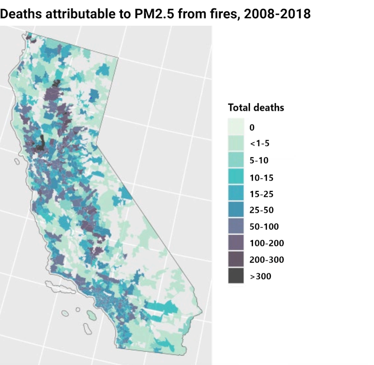
In a new study published in the journal Science Advances, we found that wildfire smoke likely contributed to more than 52,000 premature deaths across California alone from 2008 to 2018, with an economic impact from the deaths of more than US$430 billion.
Previous studies have examined the short-term health risks from wildfire smoke, but few have assessed how exposure to wildfire smoke over years adds up to shorten human lives.
Smoke from far-off wildfires turns the skies orange over San Francisco in 2020. Running in wildfire smoke carries harmful particles deep into a person’s lungs.AP Photo/Tony Avelar
As fires are becoming a regular occurrence in all of our lives, it’s important for communities to understand that the health risk from smoke pollution is rising, too.
Health risks
Decades of air pollution research have shown how exposure to fine particulate matter, or PM2.5, can harm a person’s long-term health.
PM2.5 is a mixture of small particles, each only a fraction of the width of a human hair. It comes from a variety of sources, such as vehicle tailpipes and factory emissions, as well as from other sources, including fires. The particles are so tiny, they can travel deep into the lungs and even enter the bloodstream.
Inhaling PM2.5 can cause short-term respiratory health problems in vulnerable populations, such as people with asthma and older adults. It also leads to long-term harm by contributing to the formation of chronic diseases, including atherosclerosis, asthma, decreases in lung function and diabetes. One reason this happens is the body’s inflammatory response to inhaling air pollutants.
Wildfire smoke contains a stew of chemicals. A growing body of research indicates that wildfire PM2.5 may have unique physical and chemical components that increase toxicity. For example, a study from the University of California, Davis, showed that wildfire smoke caused more inflammation in the lungs of rats than PM2.5 from other sources such as cars and industry. This makes the pollutant potentially more harmful to human respiratory health compared with the typical PM2.5 that people are exposed to in urban environments.
The problem with wildfire smoke
We examined the long-term health damages from breathing wildfire smoke. The results, from over a decade, suggest that in years with lots of fire activities – 2017 and 2018, for example – wildfire smoke contributed to more than 10,000 deaths annually in California. For comparison, about 4,000 people die in California from traffic accidents each year.
Even though most fires are in rural, forested areas, smoke can travel hundreds or thousands of miles. So the health effects are widespread through population centers.
For example, California’s Rough Fire of 2015 burned more than 150,000 acres in a mostly rural area of Fresno County, but most mortality impacts in that year were west of the fire in a more populated area of the county and throughout the San Joaquin Valley. In 2018, the year the town of Paradise and several other communities burned, wildfire smoke may have killed as many as 12,000 Californians prematurely.
To conduct this analysis, we looked at annual estimates of wildfire smoke PM2.5 by ZIP code based on wildfire activity. Unlike most past studies, we looked specifically at exposure to PM2.5 from wildfires. This allowed us to account for that potentially increased toxicity of smoke.
Then, we used a dose-response estimate for the relationship between wildfire-specific air pollution and premature deaths. Dose-response estimates are derived from epidemiological studies that relate air pollution levels to survival. For this study, we adjusted an existing dose-response estimate to account for potential increased toxicity from wildfire smoke.
These findings suggest that society needs to invest in coordinated forest management, wildland-urban interface management and climate change mitigation, all of which could yield significant public health benefits through reducing the frequency and severity of wildfires and smoke exposure. We will also need to invest more to adapt to the worsened smoke by providing safe areas in schools and other public buildings.
Here are some tips for limiting how much smoke you inhale on days when the wind is carrying wildfire smoke your way:
Stay indoors: On heavy smoke days, don’t go outside, and close your windows. Turn on an air purifier, if you have one. If you don’t have one, considering purchasing one with a HEPA filter. The California Air Resources Board has a list of certified air filters. If you smell smoke, or know there is a fire nearby – even if you can’t see it – check a resource such as the EPA and Forest Service’s AirNow Fire and Smoke Map or the PurpleAir map to get a sense of whether it’s safe to be outdoors.
Wear a protective mask: If you do go outside, wear a protective mask, such as an N95 if possible. If you don’t have access to an N95, a surgical mask will help too.
Stay informed: You can follow state and federal air quality agencies in your region on their websites and social media platforms and sign up for alerts when available.
LAKE COUNTY, Calif. — Lake County Animal Care and Control has more new dogs in its kennels this week that need new families.
Dogs available for adoption this week include mixes of Australian cattle dog, German shepherd, Great Pyrenees, husky, Labrador Retriever, mastiff, pit bull terrier, Rottweiler and terrier.
Dogs that are adopted from Lake County Animal Care and Control are either neutered or spayed, microchipped and, if old enough, given a rabies shot and county license before being released to their new owner. License fees do not apply to residents of the cities of Lakeport or Clearlake.
Those dogs and the others shown on this page at the Lake County Animal Care and Control shelter have been cleared for adoption.
Call Lake County Animal Care and Control at 707-263-0278 or visit the shelter online for information on visiting or adopting.
The shelter is located at 4949 Helbush in Lakeport.
Email Elizabeth Larson at This email address is being protected from spambots. You need JavaScript enabled to view it.. Follow her on Twitter, @ERLarson, or Lake County News, @LakeCoNews.
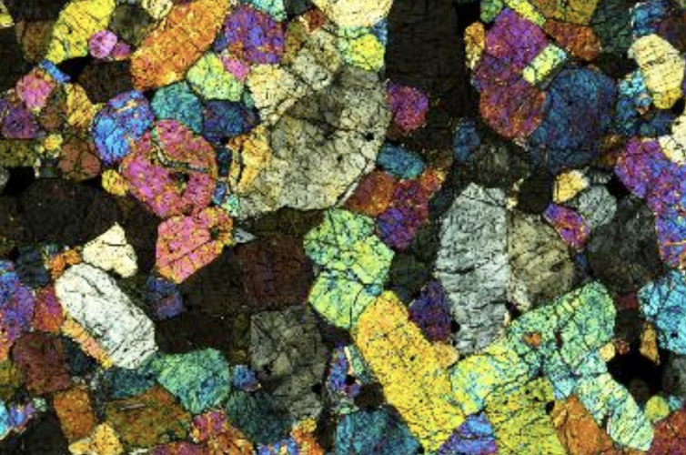
A Martian meteorite in cross-polarized light. This meteorite is dominated by the mineral olivine. Each grain is about half a millimeter across. James Day
Of the more than 74,000 known meteorites – rocks that fall to Earth from asteroids or planets colliding together – only 385 or so stones came from the planet Mars.
It’s not that hard for scientists to work out that these meteorites come from Mars. Various landers and rovers have been exploring Mars’ surface for decades. Some of the early missions – the Viking landers – had the equipment to measure the composition of the planet’s atmosphere. Scientists have shown that you can see this unique Martian atmospheric composition reflected in some of these meteorites.
Mars also has unique oxygen. Everything on Earth, including humans and the air we breathe, is made up of a specific composition of the three isotopes of the element oxygen: oxygen-16, oxygen-17 and oxygen-18. But Mars has an entirely different composition – it’s like a geochemical fingerprint for being Martian.
The Martian meteorites found on Earth give geologists like me hints about the makeup of the red planet and its history of volcanic activity. They allow us to study Mars without sending a spacecraft 140 million miles away.
A planet of paradoxes
These Martian meteorites formed from once red-hot magma within Mars. Once these volcanic rocks cooled and crystallized, radioactive elements within them started to decay, acting as a radiometric clock that enables scientists to tell when they formed.
From these radiometric ages, we know that some Martian meteorites are as little as 175 million years old, which is – geologically speaking – quite young. Conversely, some of the Martian meteorites are older, and formed close to the time Mars itself formed.
These Martian meteorites tell a story of a planet that has been volcanically active throughout its entire history. In fact, there’s potential for Martian volcanoes to erupt even today, though scientists have never seen such an eruption.
The rocks themselves also preserve chemical information that indicates some of the major events on Mars happened early in its history. Mars formed quite rapidly, 4.5 billion years ago, from gas and dust that made up the early solar system. Then, very soon after formation, its interior separated out into a metallic core and a solid rocky mantle and crust.
Since then, very little seems to have disturbed Mars’ interior – unlike Earth, where plate tectonics has acted to stir and homogenize its deep interior. To use a food analogy, the Earth’s interior is like a smoothie and Mars’ is like a chunky fruit salad.
Martian meteorite samples are prepared for analysis in a clean lab.James Day
Martian volcano remnants
Understanding how Mars underwent such an early and violent adolescence, yet still may remain volcanically active today, is an area of great interest to me. I would like to know what the inside of Mars looks like, and how its interior makeup might explain features, like volcanoes, on the red planet’s surface.
When geologists set out to answer questions about volcanism on Earth, we typically examine lava samples that erupted at different places or times from the same volcano. These samples allow us to disentangle local processes specific to each volcano from planetary processes that take place at a larger scale.
It turns out we can do the same thing for Mars. The rather exotically named nakhlite and chassignite meteorites are a group of rocks from Mars that erupted from the same volcanic system some 1.3 billion years ago.
Along with the much more common shergottites, which are also basaltic rocks, and a few other more exotic Martian meteorite types, these categories of meteorite constitute all the rocks researchers possess from the red planet.
When studied together, nakhlites and chassignites tell researchers several things about Mars. First, as the molten rock that formed them oozed to the surface and eventually cooled and crystallized, some surrounding older rocks melted into them.
That older rock doesn’t exist in our meteorite collection, so my team had to tease out its composition from the chemical information we obtained from nakhlites. From this information, we learned that the older rock was basaltic in composition and chemically distinct from other Martian meteorites. We found that it had been chemically weathered by exposure to water and brine.
This older rock is quite different from the Martian crust samples in our meteorite collection today. In fact, it is much more like what we would expect the Martian crust to look like, based on data gathered by rover missions and satellites orbiting Mars.
We know that the magmas that made nakhlites and chassignites come from a distinct portion of Mars’ mantle. The mantle is the rocky portion between Mars’ crust and metallic core. These nakhlites and chassignites come from the solid rigid shell at the top of Mars’ mantle, known as the mantle lithosphere, and this source makes them distinct from the more common shergottites.
Shergottites come from at least two sources within Mars. They may come from parts of the mantle just beneath the lithosphere, or even the deep mantle, which is closer to the planet’s metallic core.
The interior structure of Mars, with the sources of meteorites indicated.James Day
Understanding how volcanoes on Mars work can inform future research questions to be addressed by missions to the planet. It can also help scientists understand whether the planet has ever been habitable for life, or if it could be in the future.
Hints at habitability
Earth’s active geological processes and volcanoes are part of what makes our planet habitable. The gases emanating from volcanoes are a major part of our atmosphere. So if Mars has similar geological processes, that could be good news for the potential habitability of the red planet.
Mars is much smaller than Earth, however, and studies suggest that it’s been losing the chemical elements essential for a sustainable atmosphere since it formed. It likely won’t look anything like Earth in the future.
Our next steps for understanding Mars lie in learning how the basaltic shergottite meteorites formed. These are a diverse and richly complex set of rocks, ranging in age from 175 million years to 2.4 billion years or so.
Studying these meteorites in greater detail will help to prepare the next generation of scientists to analyze rocks collected using the Perseverance Rover for the forthcoming NASA Mars Sample Return mission.
 How to resolve AdBlock issue?