How to resolve AdBlock issue?
News
- Details
- Written by: Dr. Tony Phillips
On Friday morning, an armada of spacecraft witnessed something that many experts thought impossible: Comet Lovejoy flew through the hot atmosphere of the sun and emerged intact.
"It's absolutely astounding," said Karl Battams of the Naval Research Lab in Washington, DC. "I did not think the comet's icy core was big enough to survive plunging through the several million degree solar corona for close to an hour, but Comet Lovejoy is still with us."
The comet's close encounter was recorded by at least five spacecraft: NASA's Solar Dynamics Observatory and twin STEREO probes, Europe's Proba2 microsatellite, and the ESA/NASA Solar and Heliospheric Observatory.
The most dramatic footage so far comes from SDO, which saw the comet go in and then come back out again, shown in the videos on this page.
In the SDO movies, the comet's tail wriggles wildly as the comet plunges through the sun's hot atmosphere only 120,000 km above the stellar surface.
This could be a sign that the comet was buffeted by plasma waves coursing through the corona. Or perhaps the tail was bouncing back and forth off great magnetic loops known to permeate the sun's atmosphere. No one knows.
"This is all new," said Battams. "SDO is giving us our first look1 at comets travelling through the sun's atmosphere. How the two interact is cutting-edge research."
“The motions of the comet material in the sun’s magnetic field are just fascinating,” adds SDO project scientist Dean Pesnell of the Goddard Space Flight Center. “The abrupt changes in direction reminded me of how the solar wind affected the tail of Comet Encke in 2007.”
Comet Lovejoy was discovered on Dec. 2, 2011, by amateur astronomer Terry Lovejoy of Australia.
Researchers quickly realized that the new find was a member of the Kreutz family of sungrazing comets.
Named after the German astronomer Heinrich Kreutz, who first studied them, Kreutz sungrazers are fragments of a single giant comet that broke apart back in the 12th century (probably the Great Comet of 1106).
Kreutz sungrazers are typically small (~10 meters wide) and numerous. The Solar and Heliospheric Observatory sees one falling into the sun every few days.
At the time of discovery, Comet Lovejoy appeared to be at least 10 times larger than the usual Kreutz sungrazer, somewhere in the in the 100 to 200 meter range. In light of Friday's events, researchers are re-thinking those numbers.
"I'd guess the comet's core must have been at least 500 meters in diameter; otherwise it couldn't have survived so much solar heating," said Matthew Knight. "A significant fraction of that mass would have been lost during the encounter. What's left is probably much smaller than the original comet."
SOHO and NASA's twin STEREO probes are monitoring the comet as it recedes from the sun. It is still very bright and should remain in range of the spacecrafts' cameras for several days to come. Researchers will be watching closely, because there a good chance for more surprises.
"There is still a possibility that Comet Lovejoy will start to fragment," continued Battams. "It’s been through a tremendously traumatic event; structurally, it could be extremely weak. On the other hand, it could hold itself together and disappear back into the recesses of the solar system."
"It's hard to say," agreed Knight. "There has been so little work on what happens to sungrazing comets after perihelion (closest approach). This continues to be fascinating.”
Dr. Tony Phillips works for the National Aeronautics and Space Administration.
Follow Lake County News on Twitter at http://twitter.com/LakeCoNews, on Tumblr at www.lakeconews.tumblr.com, on Google+, on Facebook at www.facebook.com/pages/Lake-County-News/143156775604?ref=mf and on YouTube at www.youtube.com/user/LakeCoNews .
- Details
- Written by: Lake County News reports
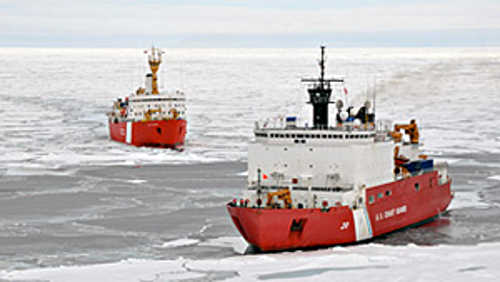
A recent mission marked the completion of a five-year collaboration between the United States and Canada to survey the Arctic Ocean.
The bilateral project collected scientific data to delineate the continental shelf beyond 200 nautical miles from the coastline, also known as the extended continental shelf (ECS).
The U.S. has an inherent interest in knowing, and declaring to others, the exact extent of its sovereign rights in the ocean as set forth in the Convention on the Law of the Sea.
For the ECS, this includes sovereign rights over natural resources on and under the seabed including energy resources such as: oil and natural gas and gas hydrates; “sedentary” creatures such as clams, crabs, and corals; and mineral resources such as manganese nodules, ferromanganese crusts, and polymetallic sulfides.
The 2011 joint Arctic mission spanned nearly six weeks in August and September and was the fourth year to employ flagship icebreakers from both countries, the U.S. Coast Guard Cutter Healy and the Canadian Coast Guard Ship Louis S. St-Laurent.
“This two-ship approach was both productive and necessary in the Arctic’s difficult and varying ice conditions,” said Larry Mayer, Ph.D., U.S. chief scientist on the Arctic mission and co-director of the NOAA-University of New Hampshire Joint Hydrographic Center. “With one ship breaking ice for the other, the partnership increased the data either nation could have obtained operating alone, saved millions of dollars by ensuring data were collected only once, provided data useful to both nations for defining the extended continental shelf, and increased scientific and diplomatic cooperation.”
Preliminary studies indicate the U.S. ECS, including the Arctic Ocean areas surveyed, total at least one million square kilometers, an area about twice the size of California. Additional data collection and analysis will lead to more accurate estimates of the extent of the U.S. ECS.
U.S. ECS work is not limited to the Arctic and includes areas in the Bering Sea, Gulf of Mexico, the Atlantic, Gulf of Alaska, Marianas and Line Islands, as well as areas off northern California and northwest of Hawaii.
In addition to Arctic survey work, the U.S. Geological Survey (USGS) led missions in 2011 to collect seismic data in the Gulf of Alaska and the Bering Sea, and scientists from the Joint Hydrographic Center collected bathymetric data northwest of Hawaii. NOAA and USGS funded the 2011 U.S. missions.
Two U.S. ECS missions are planned for 2012, one in the Atlantic and one in the Arctic.
“The amount and quality of the data collected as part of these joint Arctic missions met and often exceeded the expectations we would set each year,” said Deborah Hutchinson, Ph.D., a geologist with the USGS and U.S. science lead and liaison on board CCG Ship Louis S. St-Laurent.
This year’s U.S. Arctic mission was led by the Joint Hydrographic Center, a partnership between NOAA and the University of New Hampshire, while the Canadian mission was led by the Geological Survey of Canada of Natural Resources Canada.
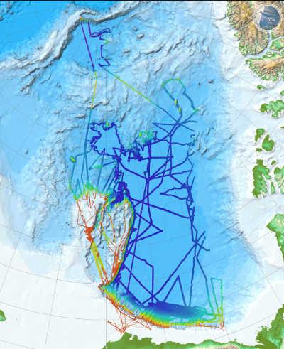
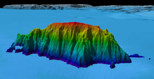
Scientists on board Healy used a multibeam echo sounder to collect bathymetric data to create three-dimensional images of the seafloor.
Scientists aboard CCGS Louis S. St-Laurent collected seismic data to determine the thickness of the sediments under the seafloor and to better understand the geology of the Arctic Ocean.
The 2011 Arctic mission traversed more than 5,600 total miles over the Beaufort Shelf, Chukchi Borderland, Alpha Ridge, and Canada Basin and reached more than 1,230 miles north of the Alaskan coast.
“As in previous Arctic missions, we obtained data in areas we were not entirely sure the ice would allow us to proceed, even with a two-ship operation,” said Andy Armstrong, co-chief scientist on the Arctic mission and co-director of the NOAA-University of New Hampshire Joint Hydrographic Center. “This was especially true in the eastern part of the Canada Basin where some of the thickest Arctic ice is found.”
Data collected by these two nations tells other scientific stories for the first time. For example, USGS scientists collected baseline data on ocean acidification and scientists from the National Ice Center compared observed ice conditions with interpretations of the same ice seen on satellite imagery.
From 2006 to date, scientists on board CCGS Louis S. St-Laurent have collected nearly 15,000 kilometers (9,320 miles) of seismic data, vastly increasing the seismic data holdings in this area of the deep Arctic Ocean.
Scientists from the United States and Canada are using these seismic data to revise models of the origin and tectonic evolution of this poorly understood portion of the ocean.
Since the start of U.S. ECS work in the Arctic in 2003, Healy alone has mapped more than 320,000 square kilometers (123,000 square miles) of the Arctic seafloor, or about the size of Arizona.
“These data provided high resolution maps to help determine the outer limits of the U.S. ECS, while revealing previously undiscovered mountains, known as seamounts, and scours created by past glaciers and icebergs scraping along the ocean bottom 400 meters below the surface,” said Mayer.
The U.S. Extended Continental Shelf Task Force is responsible for delineating the U.S. ECS and is chaired by the Department of State with co-vice chairs from the National Oceanic and Atmospheric Administration and the Department of the Interior.
Ten additional agencies participate in the task force, including the U.S. Geological Survey, Joint Chiefs of Staff, U.S. Navy, U.S. Coast Guard, Department of Energy, National Science Foundation, Environmental Protection Agency, Bureau of Ocean Energy Management, the Arctic Research Commission, and the Executive Office of the President.
Follow Lake County News on Twitter at http://twitter.com/LakeCoNews, on Tumblr at www.lakeconews.tumblr.com, on Google+, on Facebook at www.facebook.com/pages/Lake-County-News/143156775604?ref=mf and on YouTube at www.youtube.com/user/LakeCoNews .
- Details
- Written by: Lake County News reports
Anderson said the caller claims to represent Medicare or the Social Security office and asks the consumer to verify or provide information, such as a Medicare number, bank and checking account information.
He said all consumers should be cautious when speaking to unknown individuals on the telephone, and to never give out any personal information over the phone including date of birth, Medicare or Social Security number, policy numbers, credit card numbers or bank account information.
When this information is obtained by con artists it is used for identity theft and to invade bank accounts and credit cards, Anderson said.
"If you receive one of these calls, hang up and do not give them any information," Anderson cautioned. "Medicare or Social Security employees will not contact you via phone requesting this type of information. If you have any questions about the status of your Medicare of Social Security benefits, you can contact the agencies directly."
Follow Lake County News on Twitter at http://twitter.com/LakeCoNews, on Tumblr at www.lakeconews.tumblr.com, on Google+, on Facebook at www.facebook.com/pages/Lake-County-News/143156775604?ref=mf and on YouTube at www.youtube.com/user/LakeCoNews .
- Details
- Written by: Lake County News reports