 How to resolve AdBlock issue?
News
- Details
- Written by: Elizabeth Larson
Burning since Aug. 17, the more than three dozen fires that make up the August Complex had burned a total of 212,010 acres in the forest as of Friday evening, with containment up slightly to 18 percent, forest officials reported.
Forest officials said 549 personnel are assigned to the incident.
Many of the smaller fires have been contained or burned into the larger fires, including the Doe, 172,327 acres, 31-percent contained; the Glad, 20,001 acres, 0-percent contained; and the Tatham, 9,050 acres, 11-percent contained, according to the US Forest Service. All of those fires are on the Grindstone Ranger District in Glenn County.
On the forest’s Upper Lake Ranger District, the Hull fire was discovered Aug. 19. It has burned 6,020 acres and is 5-percent contained, officials said. It was added to the complex this week.
Forest Service officials said multiple resources are working the northern perimeter of the Doe fire in cooperation with Crane Mills Timber to hold the fire along the M2 road. The fire has held from Green Springs to Buck Rock, and crews are clearing line down to Glade Flat.
The Doe fire’s perimeter is currently not impacting Jenks Place as the fire is holding along the M17 road. South of Jenks Place, the fire is backing down the ridge and will likely stop at the Eel River, officials said.
The Forest Service said firefighters have conducted structure protection actions within the area of Dead Mule and crews are continuing to construct fire containment lines.
The Doe and Glade fires are expected to join at some point in the coming days, officials said.
On the Tatham fire, the Forest Service said firefighters are working with Cal Fire and Crane Mills Timber to construct a containment line completely around its perimeter. Crews are working to tie into containment lines on the Glade fire to the M2 road.
Officials said the Hull fire made a push to the north on Thursday toward the M61 Road. That fire also is expected to join with the Doe fire. Firefighters are constructing containment lines along the southern perimeter, but fire activity has not progressed further to the south.
The Forest Service said several fires located in the Yolla Bolly-Middle Eel Wilderness also continue to be actively monitored.
At 7 p.m. Saturday, the Mendocino National Forest will host a virtual community meeting on the August Complex.
The meeting will be live-streamed through the Mendocino National Forest Facebook page. Participants also can join by phone, 888-844-9904, passcode 3096536#.
For information on the fire, community members can call 530-487-4602 or email
Email Elizabeth Larson at
- Details
- Written by: Lake County News reports
On Tuesday, Sept. 1, at 10 a.m. PG&E will join the Board of Supervisors to provide an update on the company’s Community Wildfire Safety Program and respond to questions from community members.
Presenters are expected to include Vice President of Wildfire Strategy Aaron Johnson, Director of Wildfire Mitigation Jason Regan and Microgrid Strategy Manager Jon Stallman.
Donovan Lee, PG&E’s public safety strategy specialist, and Melinda Rivera, the local public affairs representative, also will be in attendance.
Last fall, public safety power shutoffs hit Lake County hard, with power off for nearly a week.
Over the past year, PG&E has worked to limit the impact of the shutoff events and harden energy infrastructure assets against fire risk through their PG&E Community Wildfire Safety Program.
The company’s goal is to limit the number and frequency of public safety power shutoff, or PSPS, events, and by doing so limit the disruption of California communities.
PG&E has already announced the following measures, intended to make PSPS events smaller:
· Adding switches and sectionalizing devices to both distribution and transmission lines that limit the size of outages.
· Developing microgrids that use temporary generators to keep the lights on in communities where it is safe to do so.
· Conducting targeted undergrounding of power lines.
· Seeking to cut restoration times in half compared to 2019.
· A goal for 2020 of inspecting the system for damage and restoring power to 98 percent of the impacted customers within 12 daylight hours after severe weather has passed.
Additionally, to make PSPS events shorter in length, the following actions have been taken:
· Nearly doubling the exclusive-use helicopter fleet during events from 35 to 65;
· Using two airplanes with infrared cameras capable of inspecting transmission lines at night; and
· Adding more field crews to speed inspection of lines.
What these measures will mean for Lake County this fall will be discussed on Tuesday.
The board’s meeting will be viewable on Facebook and on Lake County PEG TV Channel 8.
No later than 72 hours in advance of the meeting, the agenda and Zoom info (to remotely participate and ask questions in real-time) will be available here.
You can learn more about PG&E’s Community Wildfire Safety Program and the role public safety power shutoffs can play at www.pge.com. This page even includes a video describing what is new for the PSPS Program in 2020.
To view PG&E’s seven-day weather and PSPS potential outlook, click here.
- Details
- Written by: National Aeronautics and Space Administration

A crisply rendered web application can show you where the agency's Mars 2020 mission is right now as it makes its way to the Red Planet for a Feb. 18, 2021, landing.
The last time we saw NASA's Mars 2020 Perseverance rover mission was on July 30, 2020, as it disappeared into the black of deep space on a trajectory for Mars.
But with NASA's Eyes on the Solar System, you can follow in real-time as humanity's most sophisticated rover – and the Ingenuity Mars Helicopter traveling with it – treks millions of miles over the next six months to Jezero Crater.
"Eyes on the Solar System visualizes the same trajectory data that the navigation team uses to plot Perseverance's course to Mars," said Fernando Abilleira, the Mars 2020 mission design and navigation manager at NASA's Jet Propulsion Laboratory in Southern California. "If you want to follow along with us on our journey, that's the place to be."
Eyes doesn't just let you see the distance between the Red Planet and the spacecraft at this very moment. You can also fly formation with Mars 2020 or check the relative velocity between Mars and Earth or, say, the dwarf planet Pluto.
"With all our orbital assets circling Mars as well as Curiosity and InSight on its surface, there is new data and imagery coming in all the time about the Red Planet," said Jon Nelson, visualization technology and applications development supervisor at JPL. "Essentially, if you haven't seen Mars lately through Eyes on the Solar System, you haven't seen Mars."
Dozens of controls on pop-up menus allow you to customize not just what you see – from faraway to right "on board" a spacecraft – but also how you see it: Choose the 3D mode, and all you need is a pair of red-cyan anaglyph glasses for a more immersive experience.
You don't have to stop at Mars, either. You can travel throughout the solar system and even through time. The website not only uses real-time data and imagery from NASA's fleet of spacecraft, it's also populated with NASA data going back to 1950 and projected to 2050. Location, motion, and appearance are based on predicted and reconstructed mission data.
While you're exploring, take a deeper dive into our home planet with Eyes on the Earth and travel to distant worlds with Eyes on ExoPlanets.
Managed for NASA by JPL, a division of Caltech in Pasadena, California, the Mars 2020 Perseverance rover is part of a larger program that includes missions to the Moon as a way to prepare for human exploration of the Red Planet.
Charged with returning astronauts to the Moon by 2024, NASA will establish a sustained human presence on and around the Moon by 2028 through NASA's Artemis lunar exploration plans.
For more information about the mission, go to https://mars.nasa.gov/mars2020/.
For more about NASA's Moon to Mars plans, visit https://www.nasa.gov/topics/moon-to-mars.
- Details
- Written by: Elizabeth Larson
LAKE COUNTY, Calif. – The effort to contain the massive LNU Lightning Complex that stretches across six counties gained more ground on Friday, as firefighters kept the incident to a small amount of growth and more evacuees in Lake’s neighboring counties were allowed to go home.
The complex’s size increased by 1,095 acres during the day on Friday to a total of 372,344 acres by nightfall, with containment remaining unchanged at 35 percent, according to Cal Fire’s Friday evening report.
The fire, burning since Aug. 17, is now the third-largest incident in California history, with the SCU Lightning Complex – still burning on the Central Coast – edging into second place at 374,471 acres and 40-percent containment, Cal Fire said.
The 2018 Mendocino Complex, at more than 459,000 acres, remains the state’s largest wildland fire incident.
More than 500 additional firefighters have been added to the LNU Lightning Complex’s firefighting force since Thursday evening, with other resources assigned including 308 engines, 67 water tenders, 17 helicopters, 40 hand crews and 77 dozers, Cal Fire reported.
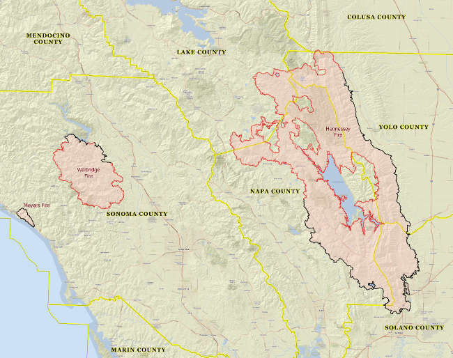
The Hennessey fire burning in Lake, Napa, Solano and Yolo counties reached 314,631 acres and 37-percent containment, Cal Fire said.
Mapping on Friday showed the northernmost tip of the Hennessey fire has now burned just inside the southwest corner of Colusa, the sixth county to be impacted by the complex.
In Sonoma County, the complex’s fires continue to be unchanged in size, with containment edging up. Cal Fire said the Walbridge Fire west of Healdsburg stands at 55,353 acres and 28-percent containment, while the Meyers Fire north of Jenner remains at 2,360 acres with containment up to 99 percent.
The improving situation allowed officials to lift some evacuation orders and warnings in Napa, Solano and Sonoma counties on Friday.
On Thursday evening, officials lifted mandatory evacuation orders for Hidden Valley Lake and a portion of Lower Lake, but other existing evacuation orders and warnings for south Lake County remained in place on Friday night.
Cal Fire said 30,500 structures are still threatened by the complex.
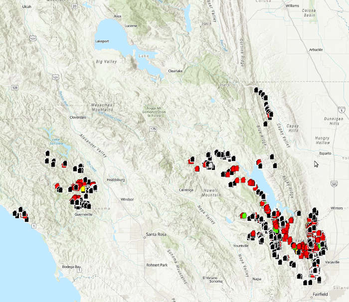
The number of structures destroyed remained at 1,080 and those damaged at 272 on Friday evening. However, Cal Fire said damage assessment teams assigned to the complex are still working through its vast footprint.
Cal Fire mapping so far shows no confirmed damaged or destroyed structures in Lake County, but that could change based on the continuing assessment work.
The National Weather Service is predicting several more days of patchy smoke and warm conditions because of the LNU Lighting Complex as well as the August Complex burning in the Mendocino National Forest.
Email Elizabeth Larson at