 How to resolve AdBlock issue?
News
- Details
- Written by: Lake County News reports
On Wednesday, the California Department of Public Health launched the “Never a Bother” campaign, a youth suicide prevention public awareness and outreach campaign for youth, young adults, and their parents, caregivers and allies.
The campaign to address youth suicide was co-created with input from California’s youth, with oversight by CDPH’s Office of Suicide Prevention.
“Young Californians are facing a mental health crisis like never before,” said CDPH Director and State Public Health Officer, Dr. Tomás J. Aragón. “While this crisis has been growing for years, the pandemic put a spotlight on the issue, especially those in marginalized and underserved communities. This campaign directly addresses this crisis with education, tools, and resources informed and co-created by diverse young people across the state."
“The ‘Never a Bother’ campaign utilizes one of the most important tools we have to address the youth mental health crisis: the voices of young people,” said First Partner Jennifer Siebel Newsom. “The youth who partnered with us to create this campaign provided invaluable insight into the resources, knowledge, and support needed to best address their needs. As a mother, I am proud to see a campaign that resonates with youth and serves as a reminder to them that they are never alone and never a bother."
“Never a Bother” was created with input from more than 400 youth from diverse communities across the state, as well as the Youth Advisory Board and 34 youth-serving community-based organizations and tribal entities from across California.
With support from The Center at Sierra Health Foundation, all of these groups are working hand-in-hand on youth suicide prevention initiatives.
Insights from in-depth research, focus groups, and listening sessions were also incorporated into all aspects of the “Never a Bother” campaign concept and strategy.
Suicide was the second leading cause of death among youth ages 10 to 25 years in California between 2018 and 2022, with youth ages 10 to 18 experiencing a more than 20% increase in suicide rates from 2019 to 2020.
The “Never a Bother” concept was chosen by youth due to the inviting and welcoming look and feel of the campaign, which includes approachable icons and language.
The campaign resonates with youth as it validates their feelings of not wanting to be a burden to others. It speaks to their need to know that they are never a bother, that no problem is too small, and that it is important to check in with one another before, during, and after a crisis.
“As we continue to prioritize the future of our youth and their mental health, California continues to invest in a significant, multi-year overhaul of our mental health system,” added Dr. Aragón. “This campaign focuses on really listening to our young people and putting resources in the hands of those who need them most."
The multilayered “Never a Bother” campaign will use traditional advertising, social media content, and community outreach strategies to reach young people across California up to age 25.
The campaign focuses on youth populations disproportionately impacted by suicide, who may also face more systemic barriers to resources and support. An additional focus includes youth who identify as 2SLGBTQIA+, have experienced mental health and/or substance use challenges, and/or have been impacted by the foster care system.
The “Never a Bother” Campaign will:
• Increase knowledge and awareness of suicide warning signs, crisis lines, and other sources of support among youth, young adults, and their caregivers.
• Help young people ask for help, know that they deserve help, and they are not a “bother,” and communicate that they are not alone in supporting themselves or a friend before, during, and after a crisis.
• Support young people reaching out for help, for themselves or for a friend.
• Strengthen parents and caregivers’ abilities to recognize warning signs of suicide and intervene.
Suicide is a complex problem requiring collaborative solutions at multiple levels, including individuals, families, schools, and communities.
Suicide prevention can only be effective when everyone is part of the solution, including:
• Learning how you can support yourself, a friend, or a youth in your care before, during, and after a crisis.
• Telling a friend or young person in your care that they are never a bother and encourage them to reach out for help when they need it.
• If you are experiencing thoughts of suicide, you are not alone. Call or text 988 to reach the Suicide & Crisis Lifeline (24/7). Trained professionals can reconnect you with your reasons to keep going and show you ways to cope with difficult days.
The "Never a Bother" campaign is the latest endeavor of Governor Gavin Newsom’s Master Plan for Kids’ Mental Health and the California Health and Human Services Agency’s Children and Youth Behavioral Health Initiative, or CYBHI.
In line with the Master Plan and CYBHI, the campaign continues the state’s effort to increase awareness of suicide prevention and mental health resources, build life-saving intervention skills, and promote help-seeking behavior.
- Details
- Written by: Mark Kreider, University of Montana
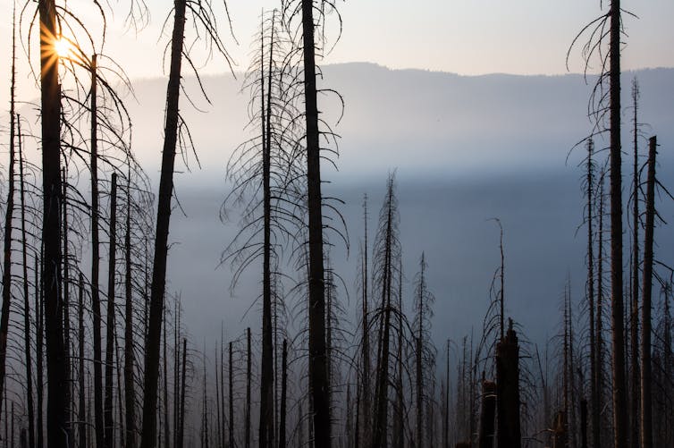
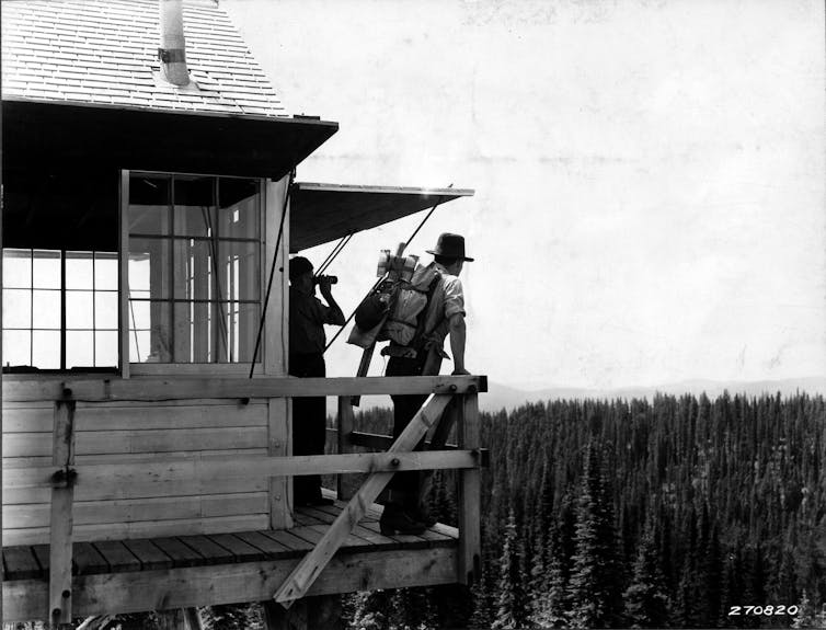
In the U.S., wildland firefighters are able to stop about 98% of all wildfires before the fires have burned even 100 acres. That may seem comforting, but decades of quickly suppressing fires has had unintended consequences.
Fires are a natural part of many landscapes globally. When forests aren’t allowed to burn, they become more dense, and dead branches, leaves and other biomass accumulate, leaving more fuel for the next fire. This buildup leads to more extreme fires that are even harder to put out. That’s why land managers set controlled burns and thin forests to clear out the undergrowth.
However, fuel accumulation isn’t the only consequence of fire suppression.
Fire suppression also disproportionately reduces certain types of fire. In a new study, my colleagues and I show how this effect, known as the suppression bias, compounds the impacts of fuel accumulation and climate change.
What happened to all the low-intensity fires?
Most wildfires are low-intensity. They ignite when conditions aren’t too dry or windy, and they can often be quickly extinguished.
The 2% of fires that escape suppression are those that are more extreme and much harder to fight. They account for about 98% of the burned area in a typical year.
In other words, trying to put out all wildfires doesn’t reduce the total amount of fire equally – instead, it limits low-intensity fires while extreme fires still burn. This effect is worsened by climate change.
Too much suppression makes fires more severe
In our study, we used a fire modeling simulation to explore the effects of the fire suppression bias and see how they compared to the effects of global warming and fuel accumulation alone.
Fuel accumulation and global warming both inherently make fires more severe. But over thousands of simulated fires, we found that allowing forests to burn only under the very worst conditions increased fire severity by the same amount as more than a century’s worth of fuel accumulation or 21st-century climate change.
The suppression bias also changes the way plants and animals interact with fire.
By removing low-intensity fires, humans may be changing the course of evolution. Without exposure to low-intensity fires, species can lose traits crucial for surviving and recovering from such events.
After extreme fires, landscapes have fewer seed sources and less shade. New seedlings have a harder time becoming established, and for those that do, the hotter and drier conditions reduce their chance of survival.
In contrast, low-intensity fires free up space and resources for new growth, while still retaining living trees and other biological legacies that support seedlings in their vulnerable initial years.
By quickly putting out low-intensity fires and allowing only extreme fires to burn, conventional suppression reduces the opportunities for climate-adapted plants to establish and help ecosystems adjust to changes like global warming.
Suppression makes burned area increase faster
As the climate becomes hotter and drier, more area is burning in wildfires. If suppression removes fire, it should help slow this increase, right?
In fact, we found it does just the opposite.
We found that while conventional suppression led to less total area burning, the yearly burned area increased more than three times faster under conventional suppression than under less aggressive suppression efforts. The amount of area burned doubled every 14 years with conventional fire suppression under simulated climate change, instead of every 44 years when low- and moderate-intensity fires were allowed to burn. That raises concerns for how quickly people and ecosystems will have to adapt to extreme fires in the future.
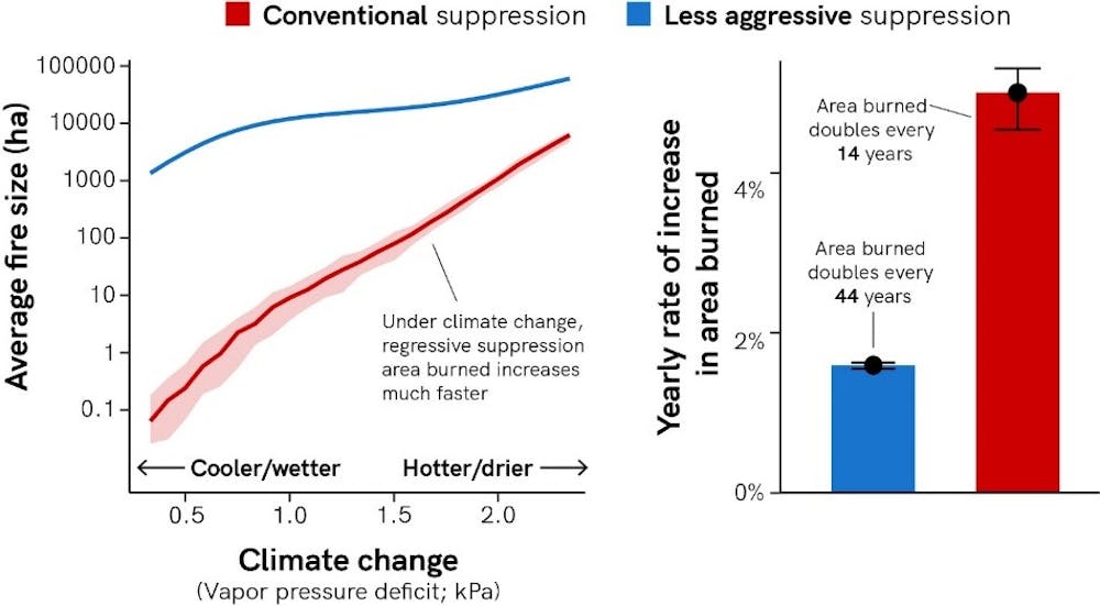
The fact that the amount of area burned is increasing is undoubtedly driven by climate change. But our study shows that the rate of this increase may also be a result of conventional fire management.
The near total suppression of fires over the last century means that even a little additional fire in a more fire-prone future can create big changes. As climate change continues to fuel more fires, the relative increase in area burned will be much bigger.
This puts more stress on communities as they adapt to increased extreme wildfires, from dealing with more wildfire smoke to even changing where people can live.
A way forward
To address the wildfire crisis, fire managers can be less aggressive in suppressing low- and moderate-intensity fires when it is safe to do so. They can also increase the use of prescribed fire and cultural burning to clear away brush and other fuel for fires.
These low-intensity fires will not only reduce the risk of future extreme fires, but they also will create conditions that favor the establishment of species better suited to the changing climate, thereby helping ecosystems adapt to global warming.
Coexisting with wildfire requires developing technologies and approaches that enable the safe management of wildfires under moderate burning conditions. Our study shows that this may be just as necessary as other interventions, such as reducing the number of fires unintentionally started by human activities and mitigating climate change.![]()
Mark Kreider, Ph.D. Candidate in Forest and Conservation Science, University of Montana
This article is republished from The Conversation under a Creative Commons license. Read the original article.
- Details
- Written by: Lake County News reports
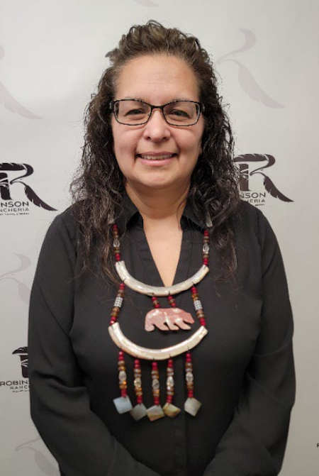
NICE, Calif. — A member of Robinson Rancheria Band of Pomo Indians who got her start at the tribe’s casino has been named the casino’s general manager, a milestone for the business.
Robinson Rancheria Resort & Casino announced that Elizabeth Anderson Nix is its new general manager, the first member of the tribe and the first woman to hold the role.
“I am extremely honored and humbled to accept the leadership role of general manager,” Nix said.
For over 30 years, Nix has been a noteworthy tribal leader in the gaming industry.
She is an enrolled tribal member of the Robinson Rancheria Band of Pomo Indians and began her career at Robinson Rancheria Resort & Casino as a blackjack dealer in 1993.
By 2005, she became the table games manager and would remain in that role for six years before taking positions at Running Creek in Lake County and Graton Resort Casino in Sonoma County.
After four years of working in other resort properties, Nix returned home to Robinson Rancheria Resort & Casino as the director of table games in 2015.
She continued her climb to the top of the leadership hierarchy and became the director of gaming operations in 2018 before being recently promoted to general manager.
In its announcement on her hire, the casino’s leadership said Nix’s table games expertise allowed Robinson Rancheria Resort & Casino to maintain its dominant position as Lake County’s premier casino in California.
Under her direction, a new smoking slot lounge has been added to the bingo room to provide another environment for players who smoke.
The smoking room is less than 10% of the total gaming space at the casino resort, which allows it to provide clean air for the nonsmokers without any interference, the casino’s announcement explained.
“As a tribal member of the Robinson Rancheria Band of Pomo Indians it’s incredibly important to me as a stakeholder, but also as a leader, to step up and help lead this organization in a direction that will provide long-term viability and sustain economic development for our tribe,” said Nix.
- Details
- Written by: Lake County News reports
The elections office said that a total of 4,499 ballots remain to be counted. That’s about 600 fewer ballots than the total count given a week ago.
This latest total count includes 4,189 vote-by-mail ballots, 266 provisional/conditional ballots, and 44 vote-by-mail ballots that require further review for various reasons.
Once the 28-day canvass is completed, then the primary results will be considered final and official, the elections office reported.
A new law that went into effect this year, AB 63, requires that the elections office update vote results and unprocessed ballot counts at least once per week and post the updated information on its website.
For more information, visit the Lake County Registrar of Voters website or call 707-263-2372 OR toll-free at 888-235-6730.