How to resolve AdBlock issue?
Refresh this page
How to resolve AdBlock issue?
Refresh this page
Lake County News,California
  • Home
    • Registration Form
  • News
    • Community
      • Obituaries
      • Letters
      • Commentary
    • Education
    • Veterans
    • Police Logs
    • Business
    • Recreation
    • Health
    • Religion
    • Legals
    • Arts & Life
    • Regional
  • Calendar
  • Contact us
    • FAQs
    • Phones, E-Mail
    • Subscribe
  • Advertise Here
  • Login

Lakeport Police, CHP and Clear Lake High School Partner for ‘Every 15 Minutes’ program focused on DUI awareness

LAKEPORT, Calif. — On Wednesday, May 14, the Lakeport Police Department joined Clear Lake High School and local emergency service agencies in delivering the Every 15 Minutes program, an emotionally impactful experience designed to educate students about the dangers of impaired and distracted driving.

The event took place near Hartley Street and Anastasia Drive and featured a simulated DUI-related traffic collision involving student participants.

The scene included a coordinated emergency response from law enforcement, fire, EMS and REACH Air Medical Services.

Students then participated in followup programming focused on real-world consequences and personal reflection.

This two-day event culminated in a school-wide assembly with guest speakers and impactful messaging.

The Every 15 Minutes program provides a powerful reminder that impaired driving affects entire communities.

By recreating the emotional realities of a fatal crash, the program encourages students to pause and consider the consequences of poor choices behind the wheel.

This initiative supports the department’s broader efforts in traffic safety and youth prevention, including the use of funding from the Cannabis Tax Fund Grant Program.

Through this grant, the Lakeport Police Department has conducted targeted DUI enforcement operations throughout the year to reduce impaired driving and promote roadway safety.

Programs like Every 15 Minutes complement these enforcement efforts by delivering critical education and early intervention.

The department is proud to have collaborated with Clear Lake High School, Lakeport Fire Protection District, California Highway Patrol – Clear Lake, Lake County Sheriff’s Office, Lake County Probation Department, REACH Air Medical Services, and many dedicated school staff and volunteers.

The Lakeport Police Department extended its deepest appreciation to the entire Lakeport community for its support.

“From educators and parents to emergency responders and behind-the-scenes volunteers, this effort would not have been possible without a shared commitment to protecting and educating our youth,” the agency said in its report on the event.

“Efforts like these serve as a solemn but vital reminder: Every decision behind the wheel matters — and every life in our community matters,” the Lakeport Police Department said.
Details
Written by: LAKE COUNTY NEWS REPORTS
Published: 17 May 2025

As US ramps up fossil fuels, communities will have to adapt to the consequences − yet climate adaptation funding is on the chopping block


Salt marshes protect shorelines, but they’re already struggling to survive sea-level rise. John Greim/LightRocket via Getty Images

It’s no secret that warming temperatures, wildfires and flash floods are increasingly affecting lives across the United States. With the U.S. government now planning to ramp up fossil fuel use, the risks of these events are likely to become even more pronounced.

That leaves a big question: Is the nation prepared to adapt to the consequences?

For many years, federally funded scientists have been developing solutions to help reduce the harm climate change is causing in people’s lives and livelihoods. Yet, as with many other science programs, the White House is proposing to eliminate funding for climate adaptation science in the next federal budget, and reports suggest that the firing of federal climate adaptation scientists may be imminent.

As researchers and directors of regional Climate Adaptation Science Centers, funded by the U.S. Geological Survey since 2011, we have seen firsthand the work these programs do to protect the nation’s natural resources and their successes in helping states and tribes build resilience to climate risks.

Here are a few examples of the ways federally funded climate adaptation science conducted by university and federal researchers helps the nation weather the effects of climate change.

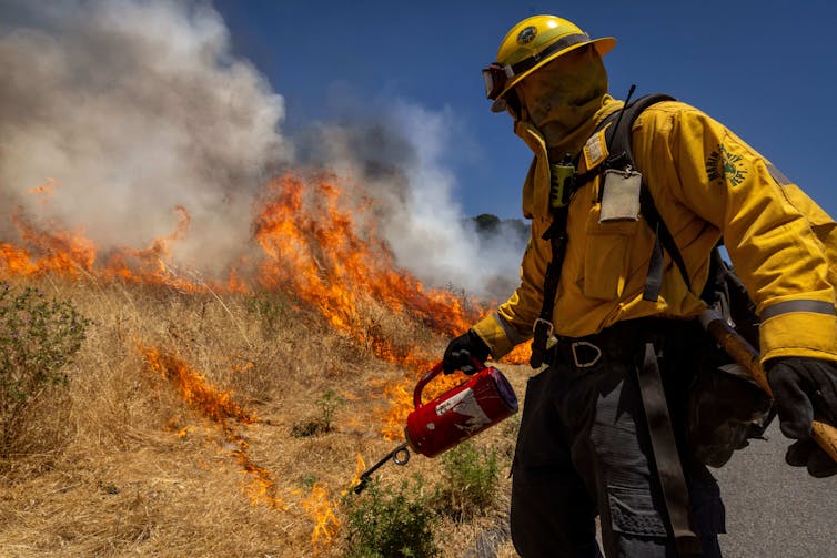
Protecting communities against wildfire risk

Wildfires have increasingly threatened communities and ecosystems across the U.S., exacerbated by worsening heat waves and drought.

In the Southwest, researchers with the Climate Adaptation Science Centers are developing forecasting models to identify locations at greatest risk of wildfire at different times of year.

Knowing where and when fire risks are highest allows communities to take steps to protect themselves, whether by carrying out controlled burns to remove dry vegetation, creating fire breaks to protect homes, managing invasive species that can leave forests more prone to devastating fires, or other measures.

The solutions are created with forest and wildland managers to ensure projects are viable, effective and tailored to each area. The research is then integrated into best practices for managing wildfires. The researchers also help city planners find the most effective methods to reduce fire risks in wildlands near homes.

A wildland firefighter in protective gear lights a controlled burn to clear away dried grasses that could fuel worse fires during fire season.
Wildland firefighters and communities have limited resources. They need to know where the greatest risks exist to take preventive measures. Ethan Swope/Getty Images

In Hawaii and the other Pacific islands, adaptation researchers have similarly worked to identify how drought, invasive species and land-use changes contribute to fire risk there. They use these results to create maps of high-risk fire zones to help communities take steps to reduce dry and dead undergrowth that could fuel fires and also plan for recovery after fires.

Protecting shorelines and fisheries

In the Northeast, salt marshes line large parts of the coast, providing natural buffers against storms by damping powerful ocean waves that would otherwise erode the shoreline. Their shallow, grassy waters also serve as important breeding grounds for valuable fish.

However, these marshes are at risk of drowning as sea level rises faster than the sediment can build up.

As greenhouse gases from burning fossil fuels and from other human activities accumulate in the atmosphere, they trap extra heat near Earth’s surface and in the oceans, raising temperatures. The rising temperatures melt glaciers and also cause thermal expansion of the oceans. Together, those processes are raising global sea level by about 1.3 inches per decade.

Adaptation researchers with the Climate Adaptation Science Centers have been developing local flood projections for the regions’ unique oceanographic and geophysical conditions to help protect them. Those projections are essential to help natural resource managers and municipalities plan effectively for the future.

Researchers are also collaborating with local and regional organizations on salt marsh restoration, including assessing how sediment builds up each marsh and creating procedures for restoring and monitoring the marshes.

Saving salmon in Alaska and the Northwest

In the Northwest and Alaska, salmon are struggling as temperatures rise in the streams they return to for spawning each year. Warm water can make them sluggish, putting them at greater risk from predators. When temperatures get too high, they can’t survive. Even in large rivers such as the Columbia, salmon are becoming heat stressed more often.

Adaptation researchers in both regions have been evaluating the effectiveness of fish rescues – temporarily moving salmon into captivity as seasonal streams overheat or dry up due to drought.

In Alaska, adaptation scientists have built broad partnerships with tribes, nonprofit organizations and government agencies to improve temperature measurements of remote streams, creating an early warning system for fisheries so managers can take steps to help salmon survive.

Managing invasive species

Rising temperatures can also expand the range of invasive species, which cost the U.S. economy billions of dollars each year in crop and forest losses and threaten native plants and animals.

Researchers in the Northeast and Southeast Climate Adaptation Science Centers have been working to identify and prioritize the risks from invasive species that are expanding their ranges. That helps state managers eradicate these emerging threats before they become a problem. These regional invasive species networks have become the go-to source of climate-related scientific information for thousands of invasive species managers.

The rise in the number of invasive species projected by 2050 is substantial in the Northeast and upper Midwest. Federally funded scientists develop these risk maps and work with local communities to head off invasive species damage. Regional Invasive Species and Climate Change Network

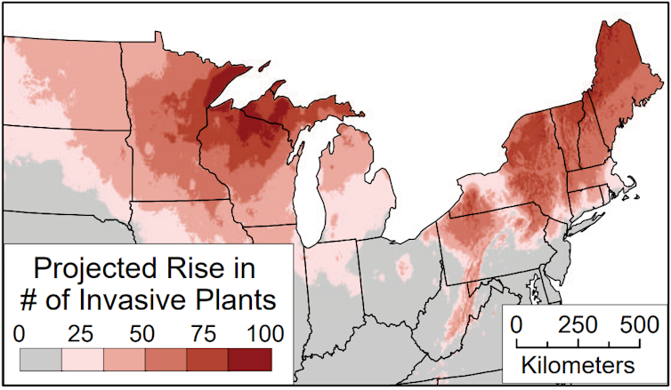
The Northeast is a hot spot for invasive species, particularly for plants that can outcompete native wetland and grassland species and host pathogens that can harm native species.

Without proactive assessments, invasive species management becomes more difficult. Once the damage has begun, managing invasive species becomes more expensive and less effective.

Losing the nation’s ability to adapt wisely

A key part of these projects is the strong working relationships built between scientists and the natural resource managers in state, community, tribal and government agencies who can put this knowledge into practice.

With climate extremes likely to increase in the coming years, losing adaptation science will leave the United States even more vulnerable to future climate hazards.The Conversation

Bethany Bradley, Professor of Biogeography and Spatial Ecology, UMass Amherst; Jia Hu, Associate Professor of Natural Resources, University of Arizona, and Meade Krosby, Senior Scientist for the Climate Impacts Group, University of Washington

This article is republished from The Conversation under a Creative Commons license. Read the original article.

Details
Written by: Bethany Bradley, UMass Amherst; Jia Hu, University of Arizona, and Meade Krosby, University of Washington
Published: 17 May 2025

Space News: NASA’s Europa Clipper captures Mars in infrared

This picture of Mars is a composite of several images captured by Europa Clipper’s thermal imager on March 1. Bright regions are relatively warm, with temperatures of about 32 degrees Fahrenheit (0 degrees Celsius). Darker areas are colder. The darkest region at the top is the northern polar cap and is about minus 190 F (minus 125 C). Photo by NASA/JPL-Caltech/ASU.

Headed for Jupiter’s moon Europa, the spacecraft did some sightseeing, using a flyby of Mars to calibrate its infrared imaging instrument.

On its recent swing by Mars, NASA’s Europa Clipper took the opportunity to capture infrared images of the Red Planet. The data will help mission scientists calibrate the spacecraft’s thermal imaging instrument so they can be sure it’s operating correctly when Europa Clipper arrives at the Jupiter system in 2030.

The mission’s sights are set on Jupiter’s moon Europa and the global ocean hidden under its icy surface. A year after slipping into orbit around Jupiter, Europa Clipper will begin a series of 49 close flybys of the moon to investigate whether it holds conditions suitable for life.

A key element of that investigation will be thermal imaging — global scans of Europa that map temperatures to shed light on how active the surface is. Infrared imaging will reveal how much heat is being emitted from the moon; warmer areas of the ice give off more energy and indicate recent activity.

The imaging also will tell scientists where the ocean is closest to the surface. Europa is crisscrossed by dramatic ridges and fractures, which scientists believe are caused by ocean convection pulling apart the icy crust and water rising up to fill the gaps.

“We want to measure the temperature of those features,” said Arizona State University’s Phil Christensen, principal investigator of Europa Clipper’s infrared camera, called the Europa Thermal Imaging System (E-THEMIS). “If Europa is a really active place, those fractures will be warmer than the surrounding ice where the ocean comes close to the surface. Or if water erupted onto the surface hundreds to thousands of years ago, then those surfaces could still be relatively warm.”

Why Mars

On March 1, Europa Clipper flew just 550 miles (884 kilometers) above the surface of Mars in order to use the planet’s gravitational pull to reshape the spacecraft’s trajectory. Ultimately, the assist will get the mission to Jupiter faster than if it made a beeline for the gas giant, but the flyby also offered a critical opportunity for Europa Clipper to test E-THEMIS.

For about 18 minutes on March 1, the instrument captured one image per second, yielding more than a thousand grayscale pictures that were transmitted to Earth starting on May 5. After compiling these images into a global snapshot of Mars, scientists applied color, using hues with familiar associations: Warm areas are depicted in red, while colder areas are shown as blue.

By comparing E-THEMIS images with those made from established Mars data, scientists can judge how well the instrument is working.

“We wanted no surprises in these new images,” Christensen said. “The goal was to capture imagery of a planetary body we know extraordinarily well and make sure the dataset looks exactly the way it should, based on 20 years of instruments documenting Mars.”

NASA’s Mars Odyssey orbiter, launched in 2001, carries a sister instrument named THEMIS that has been capturing its own thermal images of the Red Planet for decades. To be extra thorough, the Odyssey team collected thermal images of Mars before, during, and after Europa Clipper’s flyby so that Europa scientists can compare the visuals as an additional gauge of how well E-THEMIS is calibrated.

Europa Clipper also took advantage of the close proximity to Mars to test all the components of its radar instrument in unison for the first time. The radar antennas and the wavelengths they produce are so long that it wasn’t possible for engineers to can do that in a clean room before launch. The radar data will be returned and analyzed in the coming weeks and months, but preliminary assessments of the real-time telemetry indicate that the test went well.

To leverage the flyby even further, the science team took the opportunity to ensure that the spacecraft’s telecommunication equipment will be able to conduct gravity experiments at Europa. By transmitting signals to Earth while passing through Mars’ gravity field, they were able to confirm that a similar operation is expected to work at Europa.

Europa Clipper launched from NASA’s Kennedy Space Center in Florida on Oct. 14, 2024, via a SpaceX Falcon Heavy, embarking on a 1.8 billion-mile (2.9 billion-kilometer) journey to Jupiter, which is five times farther from the Sun than Earth is. Now that the probe has harnessed the gravity of Mars, its next gravity assist will be from Earth in 2026.

More about Europa Clipper

Europa Clipper’s three main science objectives are to determine the thickness of the moon’s icy shell and its interactions with the ocean below, to investigate its composition, and to characterize its geology. The mission’s detailed exploration of Europa will help scientists better understand the astrobiological potential for habitable worlds beyond our planet.

Managed by Caltech in Pasadena, California, NASA’s Jet Propulsion Laboratory in Southern California leads the development of the Europa Clipper mission in partnership with the Johns Hopkins Applied Physics Laboratory in Laurel, Maryland, for NASA’s Science Mission Directorate in Washington. APL designed the main spacecraft body in collaboration with JPL and NASA’s Goddard Space Flight Center in Greenbelt, Maryland, NASA’s Marshall Space Flight Center in Huntsville, Alabama, and Langley Research Center in Hampton, Virginia. The Planetary Missions Program Office at NASA Marshall executes program management of the Europa Clipper mission. NASA’s Launch Services Program, based at NASA Kennedy, managed the launch service for the Europa Clipper spacecraft.

Find more information about Europa Clipper here.


This picture of Mars is a colorized composite of several images captured by Europa Clipper’s thermal imager. Warm colors represent relatively warm temperatures; red areas are about 32 degrees Fahrenheit (0 degrees Celsius), and purple regions are about minus 190 F (minus 125 C). Photo by NASA/JPL-Caltech/ASU.
Details
Written by: Jet Propulsion Laboratory
Published: 17 May 2025

Veterans killed in action to be honored at May 20 ceremony

LAKE COUNTY, Calif. — During the Board of Supervisors meeting on Tuesday, May 20, there will be a special veterans mission presentation.

The presentation, which starts at 1 p.m., will be facilitated by Rick Mayo, vice president of We Serve Veterans Inc.

During this item, the board will be presented with a veterans appreciation plaque and an additional plaque listing 30 Lake County veterans killed in action since World War I.

The first of those soldiers killed was Joy Madeiros, who died in France in 1918. The Veterans Museum in Lakeport is named after him.

Representatives of organizations delivering services to Lake County’s veterans will then provide a brief overview of the supports they offer.

Following these elements, those who are able will be invited to process to the front steps of the courthouse, where the Lake County Military Funeral Honors Team will provide a Department of Defense-authorized military funeral ceremony in honor of Lake County’s veterans killed in action, including rifle volleys (ceremonial gunshots, in rapid succession).

To close the ceremony, “Taps” will be played, utilizing a 360-watt stereo built into a 50-caliber ammunition box by Mayo.

Officials offer thanks to Rick Mayo; Dave Waldschmitt, president of We Serve Veterans Inc. and chairman of the Joy Madeiros Veterans Museum; featured speaker Stephen Boone; and Wally Hammond, interim commander of the Lake County Military Funeral Honors Team for their considerable work and coordination, and to Lakeport Police Chief Dale Stoebe and the Lakeport City Council for making accommodations to provide for this historic presentation.

We Serve Veterans Inc.
Veterans Mission Presentation – 1 to 2 p.m.
Board of Supervisors Chambers and Front Courthouse Steps, 255 N. Forbes St., Lakeport

• Opening remarks by Moderator Rick Mayo

• Veterans chaplain prayer

• Dignitary welcome address

• Veterans mission overview (presentation of plaques)

• Introduction of veterans services organizations

• Lake County Military Funeral Honors Team ceremony in honor of Lake County veterans killed in action

• Ceremony concludes with the playing of “Taps”
Details
Written by: LAKE COUNTY NEWS REPORTS
Published: 16 May 2025
  • 273
  • 274
  • 275
  • 276
  • 277
  • 278
  • 279
  • 280
  • 281
  • 282

Public Safety

  • Lakeport Police logs: Saturday, Jan. 10

  • Lakeport Police logs: Friday, Jan. 9

  • Lakeport Police logs: Thursday, Jan. 8

Community

  • Wine & Beer makers, vendors sought for Symphony Winefest 2026

  • Golden State Water provides donation to support homeless community in Clearlake

  • Valentine See's Candies sales benefit community needs

Community & Business

  • Two Lake County Mediacom employees earn company’s top service awards

  • California ranks 24th in America’s Health Rankings Annual Report from United Health Foundation

  • Woodland Community College receives maximum eight-year reaffirmation of accreditation from ACCJC

  • Healthy blood donors especially vital during active flu season

  • SNHU announces Fall 2025 President's List

  • Sherick named to the Dean's List at Bob Jones University

How to resolve AdBlock issue?
Refresh this page