 How to resolve AdBlock issue?
Snow and tell: Caltrans plows ahead to help Californians navigate frosty travel
Months before Mother Nature trades short sleeves for snowshoes, Caltrans maintenance personnel throughout the Golden State begin preparations for the season’s first flurries.
Caltrans crews operate on a 24/7 schedule during adverse weather conditions to keep the roads safe.
The video above takes viewers behind the scenes as Department maintenance experts shore up more than 1,500 pieces of heavy machinery and snowplows in preparation for their deployment into wintry conditions:
Here are a few trusted driving tips that will help Californians stay safe during winter travel.
WINTER DRIVING TIPS:
• Before you get on the road, go to the Caltrans website and check QuickMap (quickmap.dot.ca.gov) for real-time traffic information or call 1-800-427-ROAD.
• Move over to allow Caltrans maintenance crews, California Highway Patrol officers, and other emergency personnel to perform the important tasks needed to keep the roads open and quickly respond to emergencies.
• Turn on your headlights to see and be seen. Be observant and maintain a safe distance behind snow removal equipment. Do not crowd the plow. Do not pass snowplows unless directed to do so by law enforcement or emergency public service personnel.
• Be prepared for delays and carry extra food, water, blankets and other essentials, and pack cell phone chargers.
• Check your tires. Make sure they are properly inflated, and the tread is in good condition.
• Always carry chains. Make sure they are the proper size for your tires and are in working order.
• Winterize your vehicle. Make sure brakes, windshield wipers, heater/defroster, and exhaust system are in good working order. Make sure fluids are topped-off, especially windshield washer fluid.
• Reduce your speed to match driving conditions and allow more time to reach your destination. • Know that bridges and ramps may be more slippery and icier than the roadway.
• Keep your electric vehicle batteries charged and your fuel tank full. Bad weather may cause long delays or closures.
• If you start sliding on snow or ice, slowly take your foot off the gas pedal and steer in the direction you wish to travel. Do not lock your brakes — pump the brakes if needed or apply steady pressure if your vehicle is equipped with anti-lock brakes.
Additional winter safe driving tips and more information about Caltrans efforts to prepare the transportation system for seasonal weather can be found on the Caltrans website.
Space News: Powerful new US-Indian satellite will track Earth’s changing surface
We don’t always notice it, but much of Earth’s surface is in constant motion. Scientists have used satellites and ground-based instruments to track land movement associated with volcanoes, earthquakes, landslides, and other phenomena.
But a new satellite from NASA and the Indian Space Research Organisation, or ISRO, aims to improve what we know and, potentially, help us prepare for and recover from natural and human-caused disasters.
The NISAR (NASA-ISRO Synthetic Aperture Radar) mission will measure the motion of nearly all of the planet’s land and ice-covered surfaces twice every 12 days.
The pace of NISAR’s data collection will give researchers a fuller picture of how Earth’s surface changes over time.
“This kind of regular observation allows us to look at how Earth’s surface moves across nearly the entire planet,” said Cathleen Jones, NISAR applications lead at NASA’s Jet Propulsion Laboratory in Southern California.
Together with complementary measurements from other satellites and instruments, NISAR’s data will provide a more complete picture of how Earth’s surface moves horizontally and vertically.
The information will be crucial to better understanding everything from the mechanics of Earth’s crust to which parts of the world are prone to earthquakes and volcanic eruptions. It could even help resolve whether sections of a levee are damaged or if a hillside is starting to move in a landslide.
What lies beneath
Targeting an early 2025 launch from India, the mission will be able to detect surface motions down to fractions of an inch. In addition to monitoring changes to Earth’s surface, the satellite will be able to track the motion of ice sheets, glaciers, and sea ice, and map changes to vegetation.
The source of that remarkable detail is a pair of radar instruments that operate at long wavelengths: an L-band system built by JPL and an S-band system built by ISRO. The NISAR satellite is the first to carry both. Each instrument can collect measurements day and night and see through clouds that can obstruct the view of optical instruments.
The L-band instrument will also be able to penetrate dense vegetation to measure ground motion. This capability will be especially useful in areas surrounding volcanoes or faults that are obscured by vegetation.
“The NISAR satellite won’t tell us when earthquakes will happen. Instead, it will help us better understand which areas of the world are most susceptible to significant earthquakes,” said Mark Simons, the U.S. solid Earth science lead for the mission at Caltech in Pasadena, California.
Data from the satellite will give researchers insight into which parts of a fault slowly move without producing earthquakes and which sections are locked together and might suddenly slip.
In relatively well-monitored areas like California, researchers can use NISAR to focus on specific regions that could produce an earthquake. But in parts of the world that aren’t as well monitored, NISAR measurements could reveal new earthquake-prone areas.
And when earthquakes do occur, data from the satellite will help researchers understand what happened on the faults that ruptured.
“From the ISRO perspective, we are particularly interested in the Himalayan plate boundary,” said Sreejith K M, the ISRO solid Earth science lead for NISAR at the Space Applications Center in Ahmedabad, India. “The area has produced great magnitude earthquakes in the past, and NISAR will give us unprecedented information on the seismic hazards of the Himalaya.”
Surface motion is also important for volcano researchers, who need data collected regularly over time to detect land movements that may be precursors to an eruption. As magma shifts below Earth’s surface, the land can bulge or sink. The NISAR satellite will help provide a fuller picture for why a volcano deforms and whether that movement signals an eruption.
Finding normal
When it comes to infrastructure such as levees, aqueducts, and dams, NISAR’s ability to provide continuous measurements over years will help to establish the usual state of the structures and surrounding land. Then, if something changes, resource managers may be able to pinpoint specific areas to examine.
“Instead of going out and surveying an entire aqueduct every five years, you can target your surveys to problem areas,” said Jones.
The data could be equally valuable for showing that a dam hasn’t changed after a disaster like an earthquake. For instance, if a large earthquake struck San Francisco, liquefaction — where loosely packed or waterlogged sediment loses its stability after severe ground shaking — could pose a problem for dams and levees along the Sacramento-San Joaquin River Delta.
“There’s over a thousand miles of levees,” said Jones. “You’d need an army to go out and look at them all.” The NISAR mission would help authorities survey them from space and identify damaged areas. “Then you can save your time and only go out to inspect areas that have changed. That could save a lot of money on repairs after a disaster.”
The NISAR mission is an equal collaboration between NASA and ISRO and marks the first time the two agencies have cooperated on hardware development for an Earth-observing mission.
Managed for the agency by Caltech, JPL leads the U.S. component of the project and is providing the mission’s L-band SAR. NASA is also providing the radar reflector antenna, the deployable boom, a high-rate communication subsystem for science data, GPS receivers, a solid-state recorder, and payload data subsystem.
The U R Rao Satellite Centre in Bengaluru, India, which leads the ISRO component of the mission, is providing the spacecraft bus, the launch vehicle, and associated launch services and satellite mission operations. The ISRO Space Applications Centre in Ahmedabad is providing the S-band SAR electronics.
To learn more about NISAR, visit https://nisar.jpl.nasa.gov.
Late night fire reported at Northshore RV park
LAKE COUNTY, Calif. — A fire that occurred late Friday night was reported to have sent a person to the hospital with burns.The fire was first reported at around 11:50 p.m. Friday at BJ Walls RV Park on Lakeshore Boulevard in Nice.
The initial dispatch stated that an RV was on fire. It was not certain if a person was in the RV, but animals were reported to be trapped inside.
The first firefighter unit to arrive found two RVs on fire, with a nearby single family home also reported to be catching fire and evacuated, according to radio reports.
Radio traffic indicated that the fire was knocked down shortly after 12:10 a.m. Saturday, with mop up expected to take up to an hour and a half.
Firefighters at the scene requested an air ambulance to respond in order to transport a burn victim to a regional trauma center, according to scanner reports.
More information on the incident was not immediately available.
Email Elizabeth Larson at
Paws for Celebration: CHP welcomes six new K9 teams
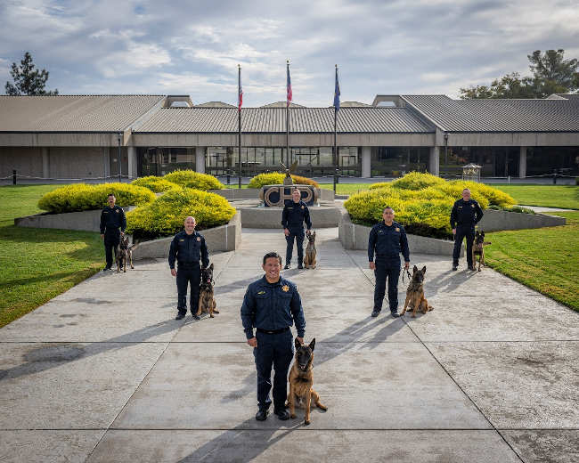
After several rigorous months of training, the California Highway Patrol is introducing six newly graduated K-9 officers into its force.
The ceremony at the CHP’s canine training facility in West Sacramento signifies the beginning of a noteworthy public safety collaboration for K-9 units and their respective handlers.
The CHP congratulates one Explosive Detection Canine team and five Patrol and Narcotics Detection Canine teams for the successful completion of the Commission on Peace Officer Standards and Training requirements.
The newest crime-fighting duos include one German Shepherd and five Belgian Malinois.
The CHP now has 49 K-9 teams deployed throughout the state.
“Our canine teams are critical to the CHP’s mission to protect and serve the public. The specialized training and strong bond between each handler and their canine partner allow us to detect threats better and apprehend suspects safely,” said CHP Commissioner Sean Duryee. “Today’s graduation celebrates the dedication of these teams and their vital role in enhancing our department’s capabilities. We proudly welcome them as part of our commitment to keeping California’s communities safe.”
A K-9 handler plays a crucial role in the training and development of a K-9 dog, as they are responsible for guiding the dog's learning process.
Both the handler and the dog must establish a strong bond built on trust and communication. The handler must learn to interpret the dog's behavior and signals, ensuring effective training techniques are applied.
Additionally, the handler is responsible for reinforcing commands and behaviors through consistent practice and patience.
Ultimately, the success of a K-9 in learning new skills heavily depends on the handler's ability to adapt to their dog's unique needs.
Once deployed, the K-9 teams receive ongoing training to prepare for evolving threats and challenges.
Monthly, the canine team completes at least eight hours of maintenance training, including odor detection, obedience, and master protection/apprehension.
The CHP has 36 patrol and narcotics detection canine teams, eight patrol and explosive canine teams, and five explosive detection canine teams deployed throughout the state.
Within these teams, CHP K-9s often participate in public demonstrations and community events to promote safety and foster positive relationships.
All K-9s are paired with a seasoned CHP officer with at least three years of professional experience. K-9s aid the CHP by performing various functions, including detecting human scent, contraband, and explosives.
The officers represent the CHP’s geographic regions of Protective Services Division, Northern, Valley, Golden Gate, Southern, and Border Division.
Join the CHP and pursue your career as a K-9 handler. You will experience a rewarding career that combines teamwork, service, and the opportunity to work with highly trained K-9 partners. If you are passionate about law enforcement and want to make a difference, we invite you to visit www.CHPMadeForMore.com to apply and become part of our dedicated team.


