How to resolve AdBlock issue?
Refresh this page
Lake County News,California
  • Home
    • Registration Form
  • News
    • Education
    • Veterans
    • Community
      • Obituaries
      • Letters
      • Commentary
    • Police Logs
    • Business
    • Recreation
    • Health
    • Religion
    • Legals
    • Arts & Life
    • Regional
  • Calendar
  • Contact us
    • FAQs
    • Phones, E-Mail
    • Subscribe
  • Advertise Here
  • Login
How to resolve AdBlock issue?
Refresh this page

News

Microplastics in the air may be leading to lung and colon cancers

Tires and degrading garbage shed tiny pieces of plastic into the air, creating a form of air pollution that UC San Francisco researchers suspect may be causing respiratory and other illnesses.

A review of some 3,000 studies implicates these particles in a variety of serious health problems. These include male and female infertility, colon cancer and poor lung function. The particles also may contribute to chronic pulmonary inflammation, which can increase the risk of lung cancer.

“These microplastics are basically particulate matter air pollution, and we know this type of air pollution is harmful,” said Tracey J. Woodruff, PhD, MPH, a professor of obstetrics, gynecology and reproductive sciences at UCSF.

Woodruff directs the Program on Reproductive Health & the Environment (PRHE) and is the senior author of the study, which appears Dec. 18 in the journal Environmental Science & Technology.

Small particles, big problem

Microplastics are less than 5 millimeters – smaller than a grain of rice – and they are ubiquitous in the environment. Each year, companies around the world produce nearly 460 million metric tons of plastic. That is projected to reach 1.1 billion by 2050.

A major source of plastic in the air is driving. Friction wears down tires along with the road surface, sending plastic fragments into the air.

Major sources of microplastics

Plastic pellets: Pellets are used in the manufacturing of other plastic products.

Personal care products: Products often contain plastic microbeads used for abrasion.

Paint: Paints and resins use polymers that are difficult to recycle.

Synthetic textiles: Fibers from synthetic textiles can be inhaled when they become airborne.

Tires: Wear and tear from tires releases airborne particles that are inhaled.

Macroplastics: Items like plastic bags and single-use containers eventually fragment into microplastics.

Animal studies believed to apply to humans, too

The paper is the first systematic review of microplastics using gold standard methods approved by the National Academy of Sciences.

Most of the studies in the review were based on animals. But the researchers said the conclusions likely also apply to humans since they share many of the same exposures.

The study expands on a report the researchers worked on last year with the California State Policy Evidence Consortium (CalSPEC). The Consortium includes experts across the UC system and provides evidence for policymakers in the California State Legislature.

“We urge regulatory agencies and policy leaders to consider the growing evidence of health harms from microplastics, including colon and lung cancer,” said Nicholas Chartres, PhD.

Chartres, the study’s first author, led the science and policy team at PRHE and is now at the University of Sydney. “We hope state leaders will take immediate action to prevent further exposures.”

Authors: Additional authors include Sheiphali Gandhi, MD, MPH, Abena BakenRa, MPH, Courtney B. Cooper, MPH, Katherine E. Pelch, PhD, and Garret Bland, PhD.

Funding: The CalSPEC pilot was funded through the University of California Office of the President Major Projects and Initiatives Fund (UCOP proposal number 202110-121-AA) and a grant from the JPB Foundation (G-2022-3608).

Clearlake Animal Control: ‘Marty’ and the dogs

"Marty." Photo courtesy of Clearlake Animal Control.

CLEARLAKE, Calif. — Clearlake Animal Control has dozens of dogs waiting for their new homes for the holidays.

The shelter has 45 adoptable dogs listed on its website.

This week’s dogs include “Marty,” a male pit bull terrier mix that is a year and nine months old, with a chocolate and copper coat.

The shelter is located at 6820 Old Highway 53. It’s open from 9 a.m. to 6 p.m. Tuesday through Saturday.

For more information, call the shelter at 707-762-6227, email This email address is being protected from spambots. You need JavaScript enabled to view it., visit Clearlake Animal Control on Facebook or on the city’s website.

This week’s adoptable dogs are featured below.

Email Elizabeth Larson at This email address is being protected from spambots. You need JavaScript enabled to view it.. Follow her on Twitter, @ERLarson, and on Bluesky, @erlarson.bsky.social. Find Lake County News on the following platforms: Facebook, @LakeCoNews; X, @LakeCoNews; Threads, @lakeconews, and on Bluesky, @lakeconews.bsky.social.


Habematolel Pomo of Upper Lake receives $2.4 million Safe Streets and Roads for All grant to improve public safety

LAKE COUNTY, Calif. — The Habematolel Pomo of Upper Lake received a $2.4 million Safe Streets and Roads for All Grant to enhance public safety measures in collaboration with the Northshore Fire Protection District.

The grant will support the Tribe's Responder, Patient and Pedestrian Safety Project, which focuses on improving the safety of emergency responders, patients, and pedestrians in Upper Lake and surrounding areas.

“This project will not only provide life-saving improvements in safety for our community but will also help us implement cutting-edge technology to support our emergency responders in their mission to protect and save lives. The collaboration with Northshore Fire Protection District exemplifies our commitment to a safer future for all in Upper Lake,” said Chairperson Danielle Cirelli of the Habematolel Pomo of Upper Lake.

“This grant is a game-changer for the safety and efficiency of emergency response in our community,” said Mike Ciancio, fire chief of the Northshore Fire Protection District. “By integrating innovative technologies and improving coordination between responders and the public, this project will enable us to respond faster, better, and more safely. We are proud to partner with the Habematolel Pomo of Upper Lake to make Upper Lake and the surrounding areas safer for everyone.”

The grant will be used to develop a comprehensive safety action plan centered around the needs of emergency responders.

This initiative will include several key components, such as an action plan focused on post-crash care and critical demonstration activities.

Among these activities are the piloting of an emergency vehicle transponder system to alert drivers to the proximity of emergency vehicles, and the testing of a platform that interfaces with specialized care registries to deliver critical health information to first responders at the scene.

Other project initiatives include investigating advanced vehicle location and vehicle informatics systems to improve monitoring and safety reporting enroute to emergency calls and performing outreach and research to build a prehospital health and safety information exchange and structured data warehouse.

Governor declares state of emergency in response to bird flu

Gov. Gavin Newsom meets with FDA Commissioner Dr. Robert Califf to discuss local, state and federal efforts to protect Californians from bird flu on Saturday, Dec. 14, 2024. Photo courtesy of the Governor’s Office.

On Wednesday, Gov. Gavin Newsom proclaimed a state of emergency to streamline and expedite the state’s response to Avian influenza A, or H5N1, commonly known as “bird flu.”

This action comes as cases were detected in dairy cows on farms in Southern California, signaling the need to further expand monitoring and build on the coordinated statewide approach to contain and mitigate the spread of the virus.

The virus has spread in 16 states among dairy cattle, following its first confirmed detection in Texas and Kansas in March.

To date, no person-to-person spread of bird flu has been detected in California and nearly all infected individuals had exposure to infected cattle.

California has already established the largest testing and monitoring system in the nation to respond to the outbreak.

This emergency proclamation will provide state and local agencies with additional flexibility around staffing, contracting, and other rules to support California’s evolving response.

“This proclamation is a targeted action to ensure government agencies have the resources and flexibility they need to respond quickly to this outbreak,” said Newsom. “Building on California's testing and monitoring system — the largest in the nation — we are committed to further protecting public health, supporting our agriculture industry, and ensuring that Californians have access to accurate, up-to-date information. While the risk to the public remains low, we will continue to take all necessary steps to prevent the spread of this virus."

Ongoing efforts to prevent spread and serious infection

California has mobilized a comprehensive cross-agency response to bird flu in dairy cattle and poultry farms to minimize farm worker exposures, reduce raw dairy product contamination and mitigate the spread of the virus.

The state has enlisted local, state and federal government technical and operational expertise to support all facets of the response; worked to educate the public, health professionals, employers, and workers on prevention and control measures to reduce the risk of exposure to bird flu; provided comprehensive information for employers and workers on personal protective equipment, or PPE, requirements; and distributed millions of pieces of PPE to high-risk workers at dairy farms.

Through coordinated public awareness efforts between the California Department of Public Health, the California Department of Food and Agriculture, California Office of Emergency Services, and other agencies, the state is leading a cross-agency response that includes timely public updates, multilingual outreach to dairy and poultry workers, targeted social media efforts to promote preventive practices, online and printed resources for the public and media interviews to keep Californians informed.

Additionally, the state is ensuring that agriculture workers have access to additional doses of seasonal flu vaccine from the Centers for Disease Control and Prevention to reduce concurrent flu risks.

Officials have also been working in close collaboration with the Centers for Disease Control, the U.S. Food and Drug Administration, the U.S. Department of Agriculture, and local health and agricultural officials, as part of a whole-of-government effort to coordinate, implement, and ensure timely surveillance and investigation of potential cases of Bird Flu.

Bird flu in the United States

Bird flu was first detected in the United States in the wild bird population in South Carolina in January 2022, and in the wild bird population in California in July 2022.

On March 25, 2024, an outbreak of bird flu in dairy cows was first reported in Texas and Kansas, and CDFA took immediate action to monitor for bird flu infections in California herds.

Since then, there have been 61 total reported confirmed cases of bird flu infection in humans across seven states, including 34 reported human cases in California.

On Aug. 30, 2024, following its detection in 13 other states, bird flu was confirmed in a dairy cow in Central California, and the California Department of Public Health immediately activated its Medical Health Coordination Center.

California Community Colleges Board of Governors adopts regulation to expand free textbooks and instructional materials

SACRAMENTO, Calif. — New regulations approved by the California Community Colleges Board of Governors will require colleges to dramatically expand the availability of free, open-source textbooks and instructional materials for students, beginning on the first day of class.

“This regulation is a bold step forward in tackling a critical issue: making textbooks and other instructional materials affordable and accessible to all of our students,” said Board President Hildegarde B. Aguinaldo. “By prioritizing affordability, students can better focus on meeting their higher education goals without added financial stress.” 

Under the new regulation, governing boards of community college districts are required to adopt policies that prioritize free instructional materials.

Once the regulation is finalized with the state of California, districts will have 180 days to put the policies into effect.

These policies are to include the following strategies:

• Developing and implementing degrees that don’t require students to pay for textbooks;
• Using open-source instructional materials complete degrees and career education certificates;
• Using free, open-source instructional materials for courses where they are commonly available, with a focus on general education requirements;
• Establishing lending programs and maintaining college library resources to ensure immediate access to course materials; and
• Strengthening student financial stability through the timely disbursement of financial aid and other institutional program resources. 

“With this regulation, we are ensuring that all students have access to the materials they need to be successful on day one,” said California Community Colleges Chancellor Sonya Christian. “Prioritizing zero-cost general education textbooks through adopting Open Educational Resources will benefit the vast majority of our students and drive progress towards our system’s Vision 2030 goals. The California Community Colleges is ensuring financial barriers no longer stand in the way of academic success.”

Currently, California college students spend an average of more than $1,100 annually on textbooks and other instructional materials — a cost that disproportionately impacts students from traditionally underserved communities.

By addressing this financial barrier, the regulation aims to prevent students from having to choose between purchasing essential materials and meeting basic needs. 

Board of Governors member Joseph R. Williams played a large role in moving this regulation forward.

“This is an issue of equity. Many of our most vulnerable students face significant financial challenges, which delays or ends their dreams of higher education. These hardships underscore the urgency of reducing costs to prevent students from choosing between essential instructional materials and basic needs. This resolution is an opportunity to truly make California Community Colleges more accessible for everyone,” said Williams.

The regulation is part of a larger effort to scale the development of zero-cost degrees and general education pathways throughout the 116-college system. 

The California Community Colleges is the largest system of higher education in the nation, composed of 73 districts and 116 colleges serving 2.1 million students per year.

No flood gauges, no warning: 99% of US streams are off the radar amid rising flash flood risks – we saw the harm in 2024


Heavy rain sent Great Brook raging over its banks in Plainfield, Vt., in July 2024. AP Photo/Ted Shaffrey

Southeast Texas was hit by flash flooding repeatedly in the spring, and then hit again by Hurricane Beryl. In one heartbreaking moment, a 4-year-old boy was swept away after his family’s car was submerged during a thunderstorm near Fort Worth.

In the Upper Midwest, days of rainfall in May caused flooding along the Mississippi River and its tributaries. A slow-moving storm in the Northeast in August caused catastrophic flooding in Connecticut.

The mountains of North Carolina and Tennessee saw some of the year’s most devastating flooding as the remnants of Hurricane Helene hit in September. Heavy rain poured down mountains, turning creeks and rivers into torrents that washed away homes and vehicles. More than 100 people died in North Carolina, and six workers drowned when their plastics factory was inundated in Tennessee.

A truck is parked at the edge of a road to alert drivers of an area where muddy water is washing over the bridge beyond.
Floodwaters rise over a bridge in Grapeland, Texas, on May 2, 2024. Texas Department of Transportation via AP

Storms like these are intensifying faster, weakening more slowly and producing more extreme precipitation that the land can’t absorb fast enough. While many coastal areas are becoming more prepared for hurricane and tidal flooding, inland flood risk is less understood or easily anticipated.

These disasters underscore the importance of fast, accurate flood warnings. They’re also a reminder that extensive gaps still exist in the systems that monitor U.S. stream levels.

Current coverage is less than 1% of waterways

The National Weather Service uses advanced models to issue flood warnings. These models rely on historical trends, land cover information and a network of over 11,800 streamgages – sensors that provide near-real-time data on precipitation, streamflow and water depth – to simulate water flow. Much of that data is available online in real time.

However, the streamgage network covers less than 1% of the nation’s rivers and streams.

Deploying a single sensor costs over US$25,000 for permanent federal gauges, and nearly 70% of these costs can fall on communities. These high upfront costs, combined with rising operational expenses, significantly limit sensor coverage — particularly in small and urban watersheds prone to flash floods.The U.S. Geological Survey acknowledges that these sensors alone do not provide enough data at fast enough intervals to fully address flood risk.

Without data, risk is often underestimated

Flood risk can be estimated in waterways without streamgages, but not as accurately.

In these areas, computers use data from similar waterways to estimate stream flow. However, these assumptions, along with limited data and the evolving effects of climate change, introduce uncertainty.

The resulting models often underestimate flow in smaller creeks and overlook the effects of urbanization. In particular, they can miss new risks in fast-developing areas, where changes to the landscape and more pavement can quickly funnel water in risky ways.

These flood models are used for more than warnings. They also guide risk assessments for development, insurance and decisions on building protective infrastructure, so accuracy is important.

A case study in Philadelphia

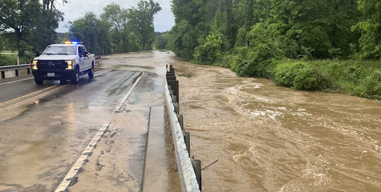
A July 2023 flash flood in Lower Makefield, a suburb of Philadelphia along the Delaware River, highlights the challenges of insufficient data coverage in urbanizing watersheds.

On July 15, heavy rain transformed Houghs Creek, a small tributary of the Delaware River, into a deadly torrent, washing out Washington Crossing Road and trapping multiple vehicles. Survivors recalled the chaos:

“All of a sudden, 3 inches of water, 4 inches of water, a foot of water just coming at us,” Chloe Weissman said.

“This huge gush of water just came down from … down a hill,” added Eli Weissman. “As it was coming down, cars were starting to float. [We] just tried to survive, laid on our back, feet heading down, grabbing trees, grabbing vines, grabbing whatever we could to stay afloat.”

A small stream running beside a road, with toppled trees and damage to the road from flooding.
This stream in the Philadelphia suburb of Lower Makefield flooded so quickly on July 15, 2023, that it toppled trees and caused cars on the road to float and crash into each other. Drivers and passengers tried desperately to grab hold of tree branches as they were swept away by the torrent. Google image
A map of the Philadelphia area shows where flooding occurred outside the warning zones
A map of rainfall totals and flash flood warnings shows how important locally targeted information can be. The flash flooding in Upper Makefield (pink) that washed away cars occurred outside the zones listed in the warning. Julie Arbit/University of Michigan

The National Weather Service issued a flash flood warning at 5:18 p.m., but a phone alert wasn’t triggered until 6:09 p.m. – after the flooding had begun. While the Delaware River has a nearby streamgage, flood models did not predict the rapid flooding along this small tributary.

Urbanization around Houghs Creek has made these events more dangerous and less predictable, as impervious surfaces quickly funnel the water into low-lying areas. The flash flood underscored the need for hyperlocal data to improve predictive models and allow earlier, more accurate warnings.

Expanding coverage of stream flood levels

Addressing data gaps is essential for improving weather forecasting and emergency management.

One promising solution is expanding the streamgage network through public-private partnerships and encouraging state and local governments, small businesses, academic institutions and nonprofits to build and operate their own sensors. Greater coverage enables more accurate and timely flood forecasts, leading to improved warnings, more prepared communities and more effective emergency responses when disasters strike.

Engineers at the University of Michigan Digital Water Lab created one example of a low-cost, easy-to-deploy solution for flood monitoring. At its core is a controller connected to an ultrasonic sensor that measures water levels in a way similar to how bats navigate using sound. The data can be transmitted in real time for fast analysis.

A person holds the controller in one image. A second image shows an open box with a circuit board.
Digital water sensors on bridges provide real-time, continuous water level monitoring, enhancing safety for drivers and supporting transportation agencies in assessing and maintaining infrastructure. Digital Water Lab/University of Michigan, CC BY-ND

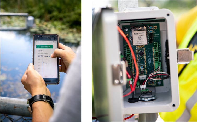
The simplicity and affordability – around US$800 per sensor – of this system allows for widespread deployment, providing critical information to communities. Techniques such as validating readings against precipitation measurements, calibrating sensors with federal monitoring stations and using supervised machine learning can build confidence in the value of this third-party and citizen-generated data.

Eventually, nonfederal sensors like these may be integrated into federal flood models.

In the meantime, researchers have created open-source databases that consolidate all known gauge data and allow the public to supply information. These combined datasets allow more advanced and robust flood models, such as Google’s flood forecasting model, which covers large portions of the country.

Future of flood monitoring

Several universities are working together in a collaboration called FloodAware to develop a system that integrates “floodcams,” social media posts, smart city sensors and more to detect and warn residents of flash floods. Bringing these tools together could greatly expand the data available to meteorologists and emergency managers, improving flood risk assessments and warnings.

Combining diverse sources of data on a shared platform would establish a more comprehensive, accessible flood monitoring system. We believe that would empower communities with the information they need to advocate for protective measures, ultimately enhancing resilience in the face of climate change.The Conversation

Julie Arbit, Researcher at the Center for Social Solutions, University of Michigan; Brad Bottoms, Data Scientist at the Center for Social Solutions, University of Michigan, and Branko Kerkez, Associate Professor of Civil Engineering, University of Michigan

This article is republished from The Conversation under a Creative Commons license. Read the original article.

Flooding is one of the deadliest and costliest natural disasters in the U.S., causing billions of dollars in damage each year. In 2024 alone, floods destroyed homes in over a dozen states and claimed more than 165 lives.
  • 337
  • 338
  • 339
  • 340
  • 341
  • 342
  • 343
  • 344
  • 345
  • 346

Community

  • Sheriff’s Activities League and Clearlake Bassmasters offer youth fishing clinic

  • City Nature Challenge takes place April 24 to 27

Public Safety

  • Lakeport Police logs: Wednesday, Feb. 11

  • Lakeport Police logs: Tuesday, Feb. 10

Education

  • Ramos measure requiring school officer training in use of anti-opioid drug moves forward

  • Lake County Chapter of CWA announces annual scholarships 

Health

  • California ranks 24th in America’s Health Rankings Annual Report from United Health Foundation

  • Healthy blood donors especially vital during active flu season

Business

  • Employment law summit takes place March 9

  • Two Lake County Mediacom employees earn company’s top service awards

Obituaries

  • Terry Knight

  • Ellen Thomas

Opinion & Letters

  • Who should pay for AI’s power? Not California ratepayers

  • Crandell: Supporting nephew for reelection in supervisorial race

Veterans

  • State honors fallen chief warrant officer killed in conflict in Iran

  • CalVet and CSU Long Beach team up to improve data collection related to veteran suicides

Recreation

  • April Audubon program will show how volunteers can help monitor local osprey nests

  • First guided nature walk of spring at Anderson Marsh State Historic Park April 11

  • Second Saturday guided nature walks continue at Anderson Marsh State Historic Park

  • Wet weather trail closure in effect on Upper Lake Ranger District

Religion

  • Kelseyville Presbyterian Church plans Easter service

  • Easter ‘Sonrise’ Service returns to Xabatin Community Park

Arts & Life

  • ‘CIA’ delves into the shadowy world of an espionage thriller

  • ‘War Machine’ shifts the battlefield into uncharted territory

Government & Politics

  • Lake County Democratic Central Committee endorses Falkenberg

  • Crandell launches reelection campaign plans March 15 event

Legals

  • April 23 hearing on Lake Coco Farms Major Use Permit

  • NOTICE OF 30-DAY PUBLIC COMMENT PERIOD & NOTICE OF PUBLIC HEARING

How to resolve AdBlock issue?
Refresh this page