 How to resolve AdBlock issue?
News
What's up for May? The Moon hangs out with Saturn twice this month, the Scorpion's "heart" briefly goes missing, and meteors in the morning, courtesy of Comet Halley.
On May 3, in the hour or so before dawn, the crescent Moon rose with Saturn in morning twilight. The pair were trailed by the Red Planet, Mars, which rose about 45 minutes after Saturn. They formed a nice lineup in the east for early risers to enjoy.
Then, on the following morning, the Moon shows a slimmer crescent and has moved between Saturn and Mars. The two planets are continuing to widen their separation following a close conjunction in early April, where they appeared super close in the sky.
And if you have a clear view to the horizon, you might just catch a glimpse of Mercury rising in the hour before the Sun. It's shining pretty brightly, but it's also low in the sky and competing with dawn twilight, so it makes for a good challenge. Those in the Southern Hemisphere will have an easier time spotting Mercury, as it rises a good bit higher in the sky for you.
On May 23, the full Moon will appear quite close to the bright red star Antares, in Scorpius, as the pair rise. But for those on the East Coast of the U.S. — south of Delaware and down through the whole state of Florida — you'll actually observe the Moon pass in front of Antares – an event called an occultation.
Over a couple of hours as the pair rise into the night sky, the Moon will move slightly in its orbit, first obscuring and then revealing Antares.
And finally, on May 31, planet Saturn rises in the wee hours of the morning with the crescent Moon in tow. If you're up early on the final day of May, you'll find the pair toward the southeast. They'll be close enough to appear in the same field of view if observing through binoculars.
May brings one of two annual meteor showers that are attributed to Halley's comet. The eta Aquariid meteors are seen each year in May, whereas the Orionid meteors streak through our skies in October.
This situation occurs because Earth crosses through Comet Halley's orbit twice every year, in May and October. Along Halley's path is a meteor stream — lots of little grains of rock and dust cast off by the comet, and these strike our atmosphere and burn up as meteors.
The shower peaks overnight on May 5th and into the morning of the 6th. You can see meteors from this shower the whole week centered around the peak night, though.
The place on the sky where the meteors appear to originate, the radiant, is in the constellation Aquarius, so you'll have a chance to see meteors as long as the radiant is above the horizon, with more meteors the higher that point rises in the sky.
This time of year, Aquarius rises after midnight, so the time to watch this shower is in the few hours before dawn.
This is a great shower for observers in the Southern Hemisphere. The radiant rises a good bit higher in the sky before morning twilight, because in May, which is autumn there, nights are longer.
Those in optimal dark sky conditions can see 40 meteors per hour. For Northern Hemisphere observers, it's less than half that amount — more like 10 to 20 meteors per hour.
It's still an above average shower, though, especially with the peak this year being near a new moon, making for a darker sky. And with the warmer temperatures that come with springtime north of the equator, it can be a worthy shower to go out and enjoy.
As always, to see the most meteors, find yourself a safe, dark spot away from bright lights and give your eyes a few minutes to adapt to the dark.
Lie down with your feet pointed more or less toward the east, and look straight overhead. Bring a warm drink and a friend or two, and turn an early morning into a “meteor morning,” as you search the skies for the eta Aquariid meteors.
Preston Dyches works for NASA's Jet Propulsion Laboratory.
- Details
- Written by: Preston Dyches
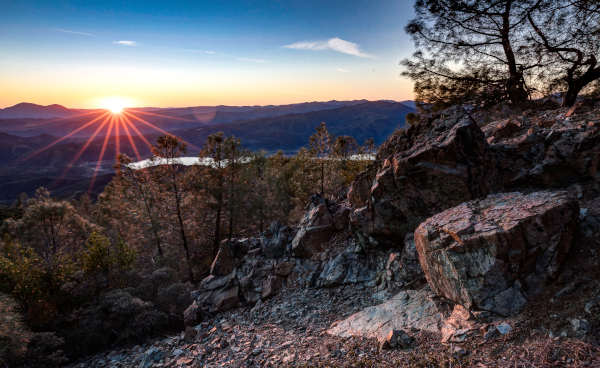
LAKE COUNTY, Calif. — Nearly nine years after its creation by presidential action, the Berryessa Snow Mountain National Monument has been expanded.
On Thursday, President Joe Biden issued a proclamation expanding the 330,780-acre monument — most of which is within Lake County’s borders — by another 13,696 acres of public lands managed by the Bureau of Land Management and located on the eastern ridge of the original monument area in Lake and Colusa counties.
The new 11-mile-long, north-south ridgeline area added to the monument encompasses the area known for many years as “Walker Ridge,” a tract which at Biden’s direction is now being renamed “Molok Luyuk,” which means “Condor Ridge” in the Patwin language of the Yocha Dehe Wintun Nation, which requested the expansion.
“We thank President Biden for expanding the Berryessa Snow Mountain National Monument and protecting Molok Luyuk, an area steeped in thousands of years of rich history and profound meaning to the Patwin people, whose traditional territory stretches south from these hills to the shores of San Pablo Bay and east to the Sacramento River,” said Yocha Dehe Tribal Chairman Anthony Roberts.
Biden’s proclamation directs Secretary of the Interior Deb Haaland to explore agreements for co-stewardship of the area with tribal nations, including the Cachil Dehe Band of Wintun Indians, Kletsel Dehe Wintun Nation, Yocha Dehe Wintun Nation and other tribal nations and Indigenous leaders “who worked tirelessly to ensure the protection of the sacred lands.”
“Molok Luyuk is a special and sacred place for area tribes and for many residents who enjoy recreation activities like hiking and mountain biking,” said Lake County Supervisor E.J. Crandell, a member of the Robinson Rancheria Tribe. “The natural beauty of our home also drives tourism, which is key to the economic vitality of the region. I am grateful that the president protected these beautiful lands. It is a gift to future generations.”
The monument encompasses public lands managed by the Bureau of Land Management and the U.S. Forest Service and runs through seven counties, from Napa in the south through Yolo, Solano, Lake, Colusa, Glenn and up to Mendocino in the north.
The region is known for its fascinating biodiversity, with the White House citing its “mosaic of unique geologic and hydrologic features,” the iconic California chaparral-covered canyons, oak and cypress woodlands, and spring-fed meadows that flank the ridge, unusual and rare serpentine wetlands and the 500 native California plant species that have been identified within the expansion area, including at least 38 different special-status plants.
Molok Luyuk also serves as a wildlife corridor for species such as tule elk, mountain lions, and bears, and is home to iconic species such as bald and golden eagles, officials reported.
In the president’s proclamation, it notes, “On a clear day, the highest points of Molok Luyuk offer a commanding view of the surrounding rugged and undeveloped landscape, encompassing Mount Shasta to the north, Mount Tamalpais to the southwest, and Sutter Buttes to the east. The view of the sun rising over Sutter Buttes to the east is central to the Patwin origin story. The expansion area contains evidence of occupation by Indigenous people for more than 10,000 years.”
Two-thirds of the monument is located within Lake County. In September 2019, the Lucerne Area Town Hall declared Lucerne as the gateway to the national monument, and two months later the Lake County Board of Supervisors adopted a proclamation also recognizing the town as the monument gateway.
A long-running effort
This expansion follows yearslong advocacy from Reps. Mike Thompson and John Garamendi; U.S. Senator Alex Padilla; federal, tribal, and local officials representing Northern California; and nongovernmental organizations, including environmental conservation, public access, outdoor recreation, and off-highway vehicle groups.
“As an avid OHV recreationist, I am thrilled at the expansion of Berryessa Snow Mountain National Monument to include Molok Luyuk,” said Don Amador, former chair of the CA State Park Off-Highway Motor Vehicle Recreation Commission and an OHV user who spoke at the meeting in favor of the expansion. “The permanent protection of Molok Luyuk will improve the management of these lands and increase public access to recreation opportunities. This is a win-win for our community. I am grateful for President Biden using the Antiquities Act to expand the monument and protect these lands for future generations to enjoy.”
In 2022, Reps. Garamendi and Thompson first introduced legislation to expand the National Monument and reintroduced the legislation this March. Both lauded the action by Biden, with Thompson noting that the expansion “will ensure the region’s biodiversity, geological formations, and cultural connections are preserved for generations to come.”
President Biden took the action through his authority under the Antiquities Act, first used by President Theodore Roosevelt in 1906 to designate Devils Tower National Monument in Wyoming. It has been used by 18 presidents of both parties since then to protect natural and historic features.
Biden was vice president when President Barack Obama used the Antiquities Act to create the monument on July 10, 2015.
The action to expand the monument was Biden’s ninth use of the Antiquities Act. Also on Thursday, he took his 10th action under the act to expand the San Gabriel Mountains National Monument in Southern California.
The two expansions protect another 120,000 acres. With those actions Biden has now created or expanded seven national monuments and restored protections for three others and conserved more than 41 million acres of lands and waters, putting him on track to conserve more lands and waters than any president in history.
The two monument expansions are part of Biden’s America the Beautiful Initiative, which is supporting locally led conservation efforts across the country with a goal to protect, conserve, and restore at least 30 percent of U.S. lands and waters by 2030.
At the same time, the Governor’s Office reported that with the action Biden took Thursday, the state now stands at 24.5% of lands conserved.
New protections for the region
One individual who has spent the last 25 years working for the creation and expansion of the Berryessa Snow Mountain National Monument is conservationist and author Bob Schneider.
Schneider is a member of the advisory council for Tuleyome, a Woodland-based nonprofit that has been a key advocate for the monument’s creation and for protections around the larger Berryessa region.
He’s the co-author of a book released in 2020, “Exploring the Berryessa Region: A Geology, Nature and History Tour,” and is now working on a second book that will take a more expansive look at the entire monument. It’s been underway for two years, “And now there’s a lot of pressure to get it done quickly.”
Schneider said the campaign to create the monument, and then to expand it, was one that involved many individuals and groups.
“The big thing about this campaign was the engagement of the tribe, the leadership they provided, the coalition that built around this, that certainly came out of what we did in the monument designation, which was a very inclusive movement,” he said.
Everyone who wanted to protect public lands could be part of it, and as a result, they built a very strong group of people, collaboratively working on that process, Schneider explained. “That actually is a good model and critical for the long term success of enjoying this place.”
He said he hopes in the next 10 years the work from monument supporters will focus more on economic development and neighboring towns and communities.
In his efforts to protect the region, Schneider also had fought against plans that had first arisen in 2010 to put dozens of wind turbines along Walker Ridge. It was estimated that the turbines would have been visible across Lake County.
However, the BLM denied the last permitting effort for the Walker Ridge wind energy project in February of 2022.
Schneider said the addition of the area formerly known as Walker Ridge to the monument will end those concerns about a wind project by protecting the ridge from it. He added that such projects are best sited on already disturbed land.
He said he believes the Molok Luyuk area is the best place to see the national monument, thanks to what can be seen here about plate tectonics, volcanic impacts, biological diversity such as plants that grow in serpentine soil, and habitat zones, as well as ranching, settlements and even old mercury mines. On top of all of that is the spiritual value for the tribes.
“On that ridge, those values really come together,” he said.
There also is a huge visual range of places to see and incredible views of surrounding areas, with Schneider noting that Condor Ridge is his favorite place for seeing all of it.
“There’s just so much in such a small space,” Schneider said.
He said he envisions an interpretive area at the ridge’s entrance with handicap accessible parking area, boardwalk, kiosk and other amenities. Schneider said Condor Ridge is a place that people can easily get to with regular vehicles.
“This provides an opportunity for everybody to build an emotional attachment to this place,” he said.
The White House proclamation noted that the name Molok Luyuk “recalls a time when California condors were a common sight soaring above the ridge, and the Patwin people would celebrate them with dances and ceremonies.”
Yocha Dehe Tribal Chairman Anthony Roberts noted, “Elements of the natural landscape on the ridge have traditional cultural significance to us. We look forward to the day when condors fly over Molok Luyuk once again.”
Schneider said the Yocha Dehe tribe is putting together a plan to reintroduce condors to the region like the Yurok Tribe has done successfully in its territory to the north.
“This could be happening in the next five years,” Schneider said of the condor reintroduction.
Email Elizabeth Larson at
- Details
- Written by: Elizabeth Larson
LAKE COUNTY, Calif. — The county of Lake said it has received a state grant to help it study the potential impacts of Pacific Gas and Electric’s proposed decommissioning of the Scott Dam.
County officials said that the California Department of Water Resources has committed $700,000 in Water Shortage Management Program funding to support the “Lake County Resource Assessment, Impact Analysis, and Adaptation Strategy Evaluation Project.”
This project will provide for analysis of the potential effects of PG&E’s proposed decommissioning of Scott Dam and impacts on Lake Pillsbury, including recreation, wildfire suppression, ecosystem, power, sediment, water supply and infrastructure such as roads.
The Lake County Board of Supervisors has been steadfast in affirming that the Scott Dam remains in place as a significant matter of priority.
Efforts to demonstrate and articulate the regional value of Lake Pillsbury can be strengthened by gathering additional data, the country said.
Officials said 600,000 Californians depend on water releases from Lake Pillsbury and the Potter Valley Project for drinking and agricultural water security, and adequate water supply is essential to every facet of our daily lives.
Should PG&E ultimately succeed in gaining Federal Energy Regulatory Commission approval to remove Scott Dam, it is essential that the potential effects and threats that may accompany that profound change be understood, officials said.
The grant funding will support the following tasks:
Identify Potter Valley Project decommissioning and climate change scenarios: Perform modeling of existing conditions, plus one or two decommissioning scenarios. Perform Climate Change modeling and include scenarios that explore extreme drought and flood conditions in the Upper Eel River watershed.
Evaluate impacts to resources and develop adaptation strategies: Technical impact analysis includes hydrological, hydraulic, and sediment modeling of the Upper Eel River and Lake Pillsbury; recreational impacts analysis; GIS and bathymetry data analysis, and economic modeling. Once impacts are identified, potential adaptation strategies will be developed.
Evaluate adaptation strategies for potential implementation: Evaluate factors like technical complexity, cost, environmental concerns, social, and other considerations related to implementation of adaptation strategies.
Report findings: Summarize the process, results and key findings.
The request for proposals to conduct the study has been issued, and the county is seeking qualified firms to further define and conduct this critical analysis. Interested parties are encouraged to visit https://lakecountyca.gov/Bids.aspx!.
“This is truly an opportunity to make a difference in Lake County and California’s future, and we are seeking firms to help ensure studies and analyses are highly effective, and can inform efforts to ensure the most responsible decision-making possible in 2025’s Federal Energy Regulatory Commission (FERC) P-77 Proceedings,” the county said in its announcement.
Lake Pillsbury is a Lake County gem. To see the beautiful landscapes, some of the wildlife that call Lake Pillsbury home, learn more about the community that has grown around Scott Dam, and more, watch the video above, presented at an October meeting of the Russian River Water Forum.
- Details
- Written by: Lake County News reports
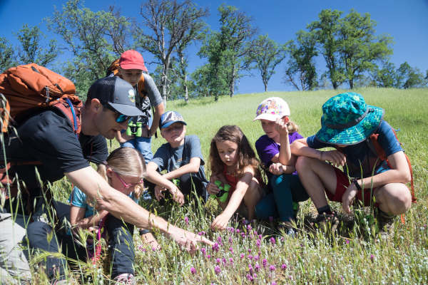
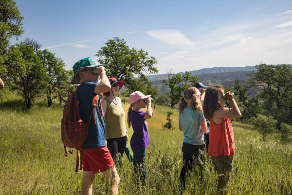
LOWER LAKE, Calif. — After the success of last year's Senior Days, the Anderson Marsh Interpretive Association, or AMIA, is bringing back a new version of Senior Days in 2024.
Programs will be both fun and educational and range from getting up close and personal with live hawks, learning about what is going on with Clear Lake, the history and culture of the Indigenous people of Anderson Marsh and Lake County, the history of the European immigrants at Anderson Marsh, and tours of the park and South Barn Interpretive Center.
In order to provide the opportunity for as many people as possible to participate, separate registrations will be required for each morning and afternoon session and registration will be limited to four sessions per person.
There will be a $5 registration fee for each session.
Time will be available between the morning and afternoon sessions to bring and enjoy a picnic lunch under the big Valley Oak in the picnic area.
AMIA encourages all Lake County seniors to visit the group’s website, take a look at the different programs and register to attend the ones that interest them.
- Details
- Written by: Elizabeth Larson