 How to resolve AdBlock issue?
Recreation
- Details
- Written by: California State Parks
A new tool in the State Parks toolkit, what3words provides dispatchers with state-of-the-art technology to assist visitors in the event they become lost, stranded or who otherwise need help from emergency services.
Using this revolutionary technology, State Parks dispatchers will now be able to pinpoint the precise locations of individuals who become lost with just three dictionary words, so that help can be sent quickly to exactly where it is needed.
what3words, integrated into RapidSOS dispatch, provides users with a simple way to communicate precise locations. It has divided the world into a grid of 10 feet by 10 feet squares, and given each square a unique combination of three words: a what3words address.
This means that every park bench, parking space, pitch on a campsite, and remote spot on a hiking trail has its own what3words address.
For example, ///tools.melted.studs takes you to the exact entrance to Jedediah Smith Redwoods State Park’s campground. The app is available in over 50 languages to date, and is free to download for both iOS and Android devices.
“Being able to locate a caller during an emergency is essential and the faster the location is confirmed, the faster help can be dispatched,” said California State Parks Director Armando Quintero. “what3words enables callers and dispatchers to communicate precise locations with just three words and quickly get the help they need.”
“From Garrapata on the Big Sur coast, to Bodie State Historic Park near the Sierra Nevada, California’s state parks offer some of the most stunning and varied landscapes on the planet, attracting explorers from across the globe,’ said what3words CMO Giles Rhys Jones. “With every 10 ft square having its own what3words address it is simpler than ever to arrange meeting spots with your friends, save precise locations of epic viewpoints, remember the space you parked in, and in the event of an emergency - describe exactly where to send help.”
what3words already covers the entire globe, so you can easily discover addresses for all 280 California state parks in its system, including all parks and campgrounds on the internal and public GIS.
In addition, the official CA State Parks app, OuterSpatial, now displays what3words addresses for over 8,000 POIs in the State Park System, including campsites, trailheads, and picnic areas.
OuterSpatial is working together with what3words to offer more ways to use precise, three-word addresses in the CA State Parks app, with updates due to be released later in the year.
what3words can also be used for non-emergencies, like giving friends and family directions to a specific campsite or sharing beautiful viewpoints. Being able to precisely communicate where to find key locations can make navigating through the vast parks simple and stress free, allowing visitors to make the best use of their time and enjoy the experience to the fullest.
- Details
- Written by: California State Parks
With 280 state parks, California’s diverse landscape has recreational activities for everyone from swimming in the lakes, rivers, and oceans to hiking in the giant redwoods or sequoias to off-highway vehicle riding in the deserts and mountains to camping along the coastline.
Following simple safety measures such as wearing a lifejacket or proper riding gear, avoiding alcohol, and knowing one’s limits while swimming can help save lives. As a reminder, fireworks are not allowed in state parks.
Just within the California State Park System, there are over 340 miles of coastline, 970 miles of lake and river frontage, 15,000 campsites, 5,200 miles of trails, 3,195 historic buildings and more than 11,000 known prehistoric and historic archaeological sites.
There are plenty of outdoor opportunities to spend time with family and friends, reconnect with nature and enjoy the benefits it offers to your mental and physical health.
Below you will find helpful tips to stay safe during this holiday weekend:
Prepare an itinerary: No matter what type of recreation activity you will be participating in, leave an itinerary of your trip with a family member/friend with information such as name/age of all participants, travel destination and expected return date. This will ensure law enforcement personnel have a better understanding of your location in the event of a rescue.
Know before you go: Prior to leaving home, check the status of the park unit you want to visit to find out what restrictions and guidelines are in place. Have a back-up plan in case your destination is crowded. Park only in designated parking spaces.
Check the weather:
• Plan activities during cooler part of the day.
• Dress in loose, lightweight, and light-colored clothing.
• Shield yourself from the sun with hats, sunglasses, and sunscreen.
• Hydrate. Drink plenty of water. Avoid alcoholic and caffeinated fluids.
• If heading to a waterway to cool off, obey posted warnings, swim in designated areas, wear a life jacket, and actively supervise children.
Wear a life jacket: Water-related accidents can happen suddenly and rapidly. Make sure you and your loved ones wear properly fitting, U.S. Coast Guard-approved life jackets. Wearing them is the number one way to increase your chances of survival during an accident. Several public and private entities make life jackets available to the public on a loan basis. View Locations
Protect your loved ones:
• Always supervise children by appointing a designated “water watcher,” taking turns with other adults. Do not assume that someone is watching your children.
• Know your limits. Swimming in a lake, ocean or river is different than swimming in a pool.
• If someone is in distress, seek help from a lifeguard or call 9-1-1 if one is not available.
Avoid alcohol: Operating your boat or an off-highway vehicle (OHV) with a blood alcohol concentration, or BAC, of 0.08% or more is against the law. Impaired boaters will be stopped and can be arrested even with lower BAC if the conditions are not safe. Your boat can be impounded. Some parks do have alcohol bans. Check specific park website to determine if there’s any local ordinances concerning alcohol.
Ocean rip currents: If you get caught in one, stay calm and do not fight the current. Swim or float parallel to the shore until you are out of the current and then swim toward the shore.
Learn the rules of recreating in boats and OHVs: There are laws specific to operating OHVs on public lands and boats on California’s waterways. Learn about them by visiting the webpage of your outdoor destination. For boating laws, please visit BoatCalifornia.com.
Trails: Whether you are hiking, horseback riding or operating an OHV, stay on designated trails. You are not only protecting natural resources, but you are also ensuring that you do not get lost. Make sure to hike with a buddy.
Leave no trace: Leave areas better than how you found them by packing out all trash. Do not disturb wildlife or plants.
You can find additional safety tips and information on backpacking, biking, camping, horseback trails, and laws can be found at https://www.parks.ca.gov/?page_id=29142.
- Details
- Written by: Nadine Strauss
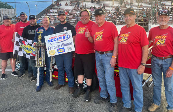
ANDERSON, Calif. — After an early race accident that eliminated Kelseyville’s Sal Martinez and Oregon driver Rich Cobb, Brandon White of Eureka took off like a bullet to lead the first half of the 60 lap Twyman Plumbing sponsored North State Modified Series main event.
But when White’s car began to push up the track it was NSMS points leader Scott Winters who made the winning pass to capture his second consecutive NSMS win at Shasta Speedway Saturday night.
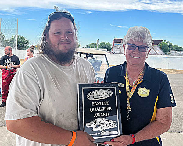
It was O’Reilly’s Night at the Races during the Shasta County Fair at Anderson, and Lakeport’s Ian Elliott earned the O’Reilly’s Fastest Qualifier Award with his top speed of 16.309 seconds on the one-third mile paved oval.
Winters clocked in second fastest at 16.324 seconds with White turning 16.434, Kris Price clocking in at 16.458, and Cobb fifth quick with a 16.576 second lap.
The invert for the start of the feature was six, placing Martinez and Cobb in the first row. The pair ran side-by-side for the first two rounds, but lap three saw Martinez break loose, hit Cobb in the rear turning Cobb’s car sideways, and then Martinez’s car motoring over the top on Cobb’s car, flattening both of Cobb’s tires. Martinez retired to the pits and Cobb had to be towed off the track.
This put White and Kris Price in the front row, and when the race resumed White took control with Elliott driving under Price for second. Winters ran fourth while White pulled away from the pack.
Winters snuck under Price on lap six and settled into third place. While Elliott and Winters were playing catch-up Cobb rejoined the group on lap 8, and at the same time Rick Avila retired his mount to the pits.
Meanwhile the battle for fifth was being waged between Calvin Hegje and teammate Jordan Smith. Smith finally prevailed, diving under Hegje on lap 17 and completing the pass the following round.
White continued to lead as Elliott was trying hard to keep Winters behind. Winters looked low, but when no opportunity presented itself for an inside pass, he drove to the high side, motored into second place and set his sights on the leader.
Winter caught White on lap 28, but on the 29th circuit, contact was made between the two resulting White’s car breaking loose. Winters backed off, allowing White to gain control. But White’s car kept drifting high, and four laps later Winters closed the deal with an inside pass for the lead on lap 34.
The next 20 laps went smoothly, but with two laps to go, Elliott dove under White and stole the runner-up spot. At the Sunoco checkered flag it was Winters followed by Elliott, White, Price and Smith. Rounding out the top 10 were Orion Mosher, Cobb, Hegje, Aliva and Martinez.
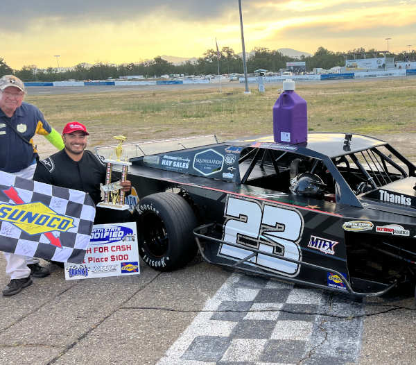
Martinez was the $100 winner of the O’Reilly’s Dash for cash with Price earning $50 for second. Brandon White won the O’Reillys Hard Charger award for leading the most laps. Martinez and Price got the Scribner jugs.
The next stop for the North State Modifieds will be July 22 at the smallest track on the tour, Lakeport Speedway. The last time NSMS ran at Lakeport was in May of 2017.
The North State Modified Series would not be possible without the support of Hoosier Tire West, Sunoco Race Fuels, Anderson Logging, Racer Bling, Mark & Sharon Baldwin, Doyce Eaton, Scribner Plastics, McMurray & Sons Roofing, Frank’s Radios and O’Reilly’s Auto Parts.
- Details
- Written by: California State Parks
This augmented reality app transports visitors through time, and its virtual reality experiences offer exciting ways for users to explore new perspectives shared by people who continue to call California home.
“We’re excited to launch the Virtual Adventurer app that further provides opportunities for Californians to access the cultural, historic and natural resources found across our beautiful state,” said California State Parks Director Armando Quintero. “The app also supports and enhances the department’s Reexamining Our Past Initiative by developing content for parks that tells a more complete, accurate and inclusive history of people and places.”
From storytelling, to holograms, to 3D images and reconstructions, the Virtual Adventurer app offers unique journeys through nine participating state parks.
For example, the public can download and travel through Coyote Canyon in today’s Anza-Borrego Desert State Park, with Maria Jacinta Bastida, an Afro-Latina woman traveling with the Juan Bautista De Anza expedition, or see Chinatown reemerge from the sagebrush at Bodie State Historic Park.
The public can continue to check the app regularly as more adventures and stories will be added to the existing parks, as well as more park units will be added to explore.
The Virtual Adventurer app is also designed to be one of the most accessible mobile applications. Users will have access to Americans with Disabilities Act-compliant accessible PDFs, audio descriptions, audio captioning, high-contrast colors, dyslexic font and more — all with the goal of ensuring the highest level of access possible to interpretive and educational content for all park visitors.
“Helping park visitors to create deeper and more meaningful experiences in state parks is vitally important to connecting us all to the rich history of these places,” said Parks California Community Engagement Director Myrian Solis Coronel. “Through this app and emerging digital technology, we hope these tools will help all visitors see themselves as part of these special places and feel a sense of belonging.” Parks California, along with other park partners like Jack London Park Partners, Point Lobos Foundation, Tribal Nations, and university partners are also supporting content development.
The app development was led by TimeLooper Inc., an immersive digital experience and exhibition firm. “State Parks came to us with a vision to expand the scope of stories told in its parks in a manner that is highly immersive and relevant to today’s park visitors,” said a TimeLooper Principal and Founder Andrew Feinberg. “Virtual Adventurer delivers an easily accessed, fuller accounting of the state’s natural and cultural history through the highly interactive capabilities of augmented and virtual reality.”
Below are the nine state parks currently participating:
Anza-Borrego Desert State Park
Bodie State Historic Park
Colonel Allensworth State Historic Park
Jack London State Historic Park
Montaña de Oro State Park
Oceano Dunes State Vehicular Recreation Area (Oso Flaco Lake)
Old Town San Diego State Historic Park
Point Lobos State Natural Reserve
Sue-meg State Park
To download the app, visit the Google or Apple app stores.
Download this app today to deepen your connection to California's remarkably diverse heritage.